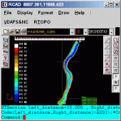
RTOPO 3.2
Simple, powerful and inexpensive CAD software for surveying. You can do triangulation, isolines, color-filled contour maps, sections, intersections, volume and much more. You can process hundreds of thousands of points or triangles.
Product Specifications
| User Rating: | item has less then 1 vote |
|
| FileCart Rating | Not yet Rated | |
| Submitted by: | rcad | |
| Homepage | Visit Homepage | |
| License | Shareware | |
| Expires | 20 Uses | |
| Price | $84 | |
| Downloads | 650 | |
| OS Support | Windows Install and Uninstall | |
| File Name | rcad.zip | |
| File Size | 0.99 MB ( 1,012 KB ) | |
| Published | Jul 07, 2010 (16 years ago) | |
| Updated | Sep 22, 2015 (10 years ago) | |
Follow Us!
Latest Searches
commercial HVAC services 7 minutes ago
hora en mexico en 24 9 minutes ago
Shin01345 13 minutes ago
bruteforce attack 15 minutes ago
cyberpowerpc gma6900wst pcpartpicker 15 minutes ago
demi rose 3.27gb 22 minutes ago
04122687938 24 minutes ago
CVE 2026 0900 vulnerability details 28 minutes ago
právo 32 minutes ago
Popular Searches
id cards 602 times
2025 422 times
2024 385 times
Softperfect 318 times
Database Workbench Pro 258 times
TeraByte Drive Image Backup and Restore 255 times
Elcomsoft Phone Breaker 251 times
Elcomsoft Phone Viewer 232 times
SAM Broadcaster Cloud 223 times
Product Details
Through its own CAD system (called RCAD), specialized for 3D and for a large number of entities, you can:
-load and draw a file of points having the format: Number X Y Z Code; the drawing is made by POINT,3DPOLY,SPLINE or BLOCK entities, according to a modifiable library of codes
-edit interactively the points; you can modify the coordinates, the code and the position (in 3DPOLY or SPLINE)
-triangulate the points on a convex hull or between an external contour and possibly more interior contours
-do isolines (contour lines) and color-filled contour map
-do cross sections and longitudinal profile
-do the projection of several PLine entities over a triangulation
-do the conversion of a triangulation to a regular grid of points
-do the conversion of the existing isolines resulting from maps in points and then in a triangulation
-represent the geological_stratification resulting from drilling
-calculate 3D area, center of gravity and the volume between 2 triangulations or between a triangulation and a plan
-intersect and divide two triangulations (or two sets of 3dmesh and 3dface entities) or a triangulation by a horizontal plan
-interpolate a set of 3DFACE entities, using quartic triangular patches (G1 continuity)
-transform a drawing containing entities as PLine, Line, Block and Text, in points having codes and then in a triangulation,
-represent 4D points cloud.
RCAD CAD system, distributed together with RTOPO, provides OpenGL real-time orbit, pan,zoom, shading, lighting and motion path animation. RCAD is similar with other popular CAD systems and can load and save DXF files. It has entries in the command text area, graphics area, menus and toolbars and can run scripts.
| Requirements: | Graphic card with OpenGL hardware acceleration and 32-bit color depth |
| Release Info: | New Release on Sep 21, 2015 |
| Release Notes: | 50% price discount until August 31, 2016! OpenGL Performance Optimization. |
| Related Tags: | CAD for Topography XYZ File Triangulation Isolines Cross sections |
Reviews
Reviews of RTOPO 3.2
You can be the first to write a review of RTOPO!Other products submitted by this publisher
An add-on for AUTOCAD or ZWCAD which determines the intersection curves between 2 sets consisting of 3DFACE, 3DSOLID or 3DMESH entities. It can also generate cross sections to a POLYLINE and can draw the conversion to 3DFACE of the 3DSOLID.
DEVELOPED SECTION for AutoCADAn add-on for AUTOCAD or BricsCAD, which determines the unfolded section of one set of 3DSOLID, 3DMESH or 3DFACE entities and vertical planes passing through a 2D POLYLINE which may contain arcs, in XOY plane. It also extract multiple PDF from a DWG.
FURNITDesign of furniture. An add-on for AutoCAD 2007-2017! You can project bodies composed from plates and assemblings. Holes, grooves or edgings can be applied. Execution drawings and lists are automatically generated.
GWB Get wooden beamsAn add-on for AUTOCAD wich identifies wooden beams from 3D DWG drawings of wooden houses. The result of the program is a drawing with the identified parts (numbered and dimensioned) and a file of quantities that can be loaded into EXCEL.
Topography in AutoCADAn add-on for AUTOCAD or BricsCAD, for the TRIANGULATION of a set of point, isolines, KML 2D and 3D creator, the VOLUME of a set of 3dface entities, loading of XYZ points files, surface flatness and sections.
