
BoatSpeedy 1.5.2
Route planner for canoes and boats, GPS speedometer and battery analytics
Download
3.92 MB
32downloads
19this week
FreeFreeware
0reviews
Screenshots
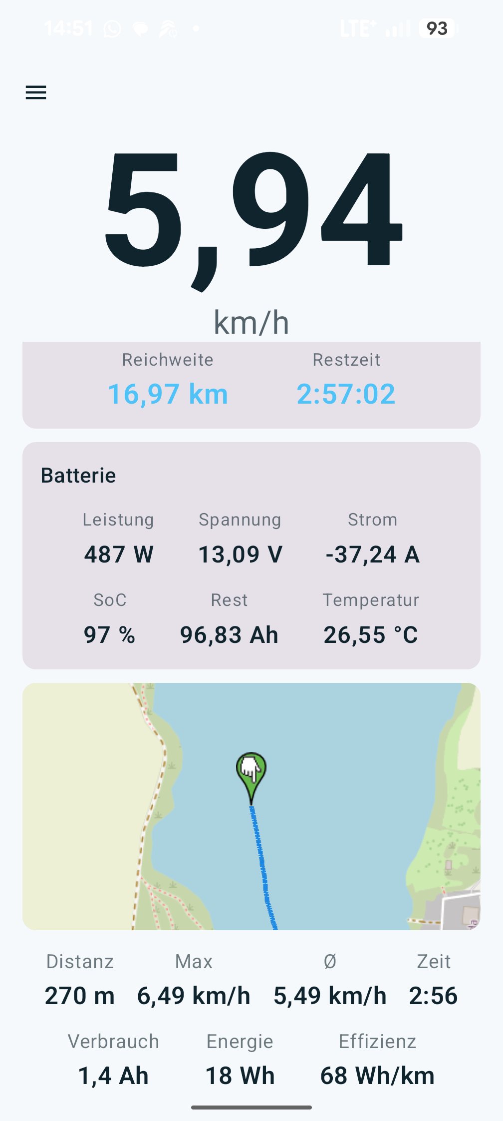
About BoatSpeedy
GPS boat speedometer and navigation for small boats. Under motor, paddle or oars. A Bluetooth BMS or a coulometer on the pack adds live values and range.
Navigation: route planner for canoes and boats
* Set a destination on the map: straight line or a route along the waterways, with distance and estimated draw
* Load the waterways onto the device as tiles, routes up to 600 km, map server selectable
* Craft type, motorboat or canoe, decides which bans apply
* Around the weir by canoe: portages, put-ins and egress points from OpenStreetMap
* Locks and weirs on the route, tap one for hours, phone and chamber size
* Seamarks are tappable, speed signs show their number
* Map north up or course up, marker and map glide
Speed and trip
* Large readout, km/h or knots, decimals configurable
* Start and stop through a foreground service, keeps measuring with the screen off
* Trip history with distance, times, Ah, Wh and Wh/km, GPX export and import
* Satellite and GPS status, smoothing of the raw value
Battery (Bluetooth LE)
* Several packs, wiring single, parallel or series
* Voltage, current, state of charge, remaining Ah, temperature, cells
* Range and remaining time at the current speed, time-averaged
* JBD and Redodo/LiTime/Power Queen verified on hardware, Daly and JK experimental
* Coulometer with a Hall sensor for packs without Bluetooth, verified too
* Charging mode with time to full and an alert at a chosen level
Weather and safety
* DWD rain radar, readings from the nearest station, wind direction
* Weather warnings for thunderstorm and storm
* Anchor watch with a drag alarm
What the app talks to
* Base map from OpenStreetMap, seamark overlay from tiles.openseamap.org
* Waterway tiles for routing from boatspeedy.wozise.de, a server run by the author. The data comes from OpenStreetMap, the generator is open source (Glenn-Dandy/boatspeedy-mapdata)
* Without matching tiles, routing asks the public Overpass servers
* Weather and warnings from the Deutscher Wetterdienst, via maps.dwd.de and api.brightsky.dev
* Update check at api.github.com, only when you tap it
Free and open source, without Google Play Services. Maps and waterways © OpenStreetMap contributors (ODbL), seamarks OpenSeaMap (CC BY-SA), weather from the Deutscher Wetterdienst (CC BY 4.0).
Website: [link removed]
License: MIT
Navigation: route planner for canoes and boats
* Set a destination on the map: straight line or a route along the waterways, with distance and estimated draw
* Load the waterways onto the device as tiles, routes up to 600 km, map server selectable
* Craft type, motorboat or canoe, decides which bans apply
* Around the weir by canoe: portages, put-ins and egress points from OpenStreetMap
* Locks and weirs on the route, tap one for hours, phone and chamber size
* Seamarks are tappable, speed signs show their number
* Map north up or course up, marker and map glide
Speed and trip
* Large readout, km/h or knots, decimals configurable
* Start and stop through a foreground service, keeps measuring with the screen off
* Trip history with distance, times, Ah, Wh and Wh/km, GPX export and import
* Satellite and GPS status, smoothing of the raw value
Battery (Bluetooth LE)
* Several packs, wiring single, parallel or series
* Voltage, current, state of charge, remaining Ah, temperature, cells
* Range and remaining time at the current speed, time-averaged
* JBD and Redodo/LiTime/Power Queen verified on hardware, Daly and JK experimental
* Coulometer with a Hall sensor for packs without Bluetooth, verified too
* Charging mode with time to full and an alert at a chosen level
Weather and safety
* DWD rain radar, readings from the nearest station, wind direction
* Weather warnings for thunderstorm and storm
* Anchor watch with a drag alarm
What the app talks to
* Base map from OpenStreetMap, seamark overlay from tiles.openseamap.org
* Waterway tiles for routing from boatspeedy.wozise.de, a server run by the author. The data comes from OpenStreetMap, the generator is open source (Glenn-Dandy/boatspeedy-mapdata)
* Without matching tiles, routing asks the public Overpass servers
* Weather and warnings from the Deutscher Wetterdienst, via maps.dwd.de and api.brightsky.dev
* Update check at api.github.com, only when you tap it
Free and open source, without Google Play Services. Maps and waterways © OpenStreetMap contributors (ODbL), seamarks OpenSeaMap (CC BY-SA), weather from the Deutscher Wetterdienst (CC BY 4.0).
Website: [link removed]
License: MIT
| Release info | Update on Oct 25, 2026 |
|---|---|
| Release notes | Neu • wozise.de auf der Über-Seite: unten neben dem Copyright, antippen öffnet die Seite. Behoben • Regenradar überarbeitet. Die Wetterkarte öffnet auf rund 150 km statt auf Straßenzoom und zeigt ohne GPS-Position Deutschland, vorher blieb sie leer. Jede Schleife gehört zu einem Vorhersagelauf des DWD und reicht bis +2 h, der Regen springt nicht mehr. Ein neuer Lauf wird im Hintergrund geladen und erst dann getauscht. Lädt schneller, mit Ladebalken. Regen ist leicht durchsichtig und hat runde Umrisse, starke Zellen behalten ihre Stufe. • Kanu: gesperrte Flussstücke werden umtragen. Ein Stück mit canoe=no oder access=no zählt wie ein Wehr. Liegt davor und dahinter ein Anleger, trägt die Route von einem zum anderen, auch ohne eingetragenen Umtrageweg. Vorher endete sie dort als Luftlinie, etwa am alten Zeiss-Wehr in Saalfeld. boat=no allein zählt nicht. versionCode 53. --- New • wozise.de on the About page: at the bottom next to the copyright, tap to open the site. Fixed • Rain radar reworked. The weather map opens at about 150 km instead of street zoom and shows Germany without a GPS fix, before it stayed empty. Each loop belongs to one DWD forecast run and reaches +2 h, rain no longer jumps. A new run loads in the background and only then replaces the old one. Loads faster, with a progress bar. Rain is slightly transparent with round outlines, strong cells keep their level. • Canoe: closed river stretches are portaged. A stretch tagged canoe=no or access=no counts like a weir. With a landing before and after it, the route carries from one to the other, even without a mapped portage path. Before, it ended there as a straight line, for example at the old Zeiss weir in Saalfeld. A bare boat=no does not count. |
| Listing data | F-Droid |
Reviews
No reviews yet. Be the first to review BoatSpeedy.
Used BoatSpeedy? Tell other visitors what you thought.
Log in to write a reviewOther products by this publisher
- "No Distractions" for YouTube 4.10 ----
- #Bible 11.5 "Incredible App - My sister shared this app with me a few weeks ago and it is truly incredible.
- #filmphotography 1.4.2 So, you decided to shoot on film?
- $quirrel 1.5.1 $quirrel Budget & Finance helps you plan each paycheck, track spending, manage debt, and see what is safe to spend before the next payday.
- % Percentage Calculator Pro 1.41 This is the Pro version of % Percentage Calculator.
Most viewed Android Navigation & Maps
-
1
 osm2gmaps 0.11.0
Convert coordinates and map links between formats, services and apps
-
2
 CairnGPS 1.3.0
Hike tracking, live GNSS satellite view, achievements. Works fully offline
-
3
 XCSoar 7.46.1
Tactical glide computer and maps
-
4
 RailTrip 1.6.5
Travel through the train stations to stamp your visa!
-
5
 Wind Bubble 1.0.3
See where the wind hits you, on top of your navigation app.
- 6 Bahn-Vorhersage 0.8.2 Ranking for train journeys according to their reliability. (German only)
- 7 GPS Locker 0.1.1 Keep the GPS locked at all times on an Android device.
- 8 CountryCount 1.0.1 Track countries, visualize your progress, and explore where you’re going next.
- 9 Helsinki Timetables 1.6 Show timetables for public transport in Helsinki city and region
-
10
 LavSeeker 2.8
LavSeeker shows toilets listed in OpenStreetMap
Most downloaded Android Navigation & Maps
-
1
CairnGPS 1.3.0
Hike tracking, live GNSS satellite view, achievements. Works fully offline
-
2
BoatSpeedy 1.5.2
Route planner for canoes and boats, GPS speedometer and battery analytics
- 3 E6B Flight Computer 2.0 This is a simulation of the E6B flight computer.
-
4
RailTrip 1.6.5
Travel through the train stations to stamp your visa!
-
5
 Tridenta 1.5
Trentino public transport: trips, lines and stops
-
6
 ParkenDD 1.2.8
Show available parking slots in major cities
-
7
 Qz 2.2.0
Receive live traffic news via Traffic Message Channel (TMC)
-
8
 Transito 0.10.0.9
Public transit app to download GTFS data & calculate routes offline
- 9 Bimba 3.99 FLOSS public transport passenger companion; a timetable in your pocket.
- 10 GPS Locker 0.1.1 Keep the GPS locked at all times on an Android device.