
OsmAnd~ 5.4.10
Global Mobile Map Viewing & Navigation for Offline and Online OSM Maps
Download
154.36 MB
28downloads
6this week
FreeFreeware
0reviews
Screenshots
About OsmAnd~
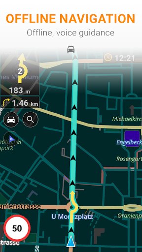
OsmAnd is an offline world map application based on OpenStreetMap (OSM), which allows you to navigate taking into account the preferred roads and vehicle dimensions. Plan routes based on inclines and record GPX tracks without an internet connection.
OsmAnd is an open source app. We do not collect user data and you decide what data the app will have access to.
Main features:
Map view
• Choice of places to be displayed on the map: attractions, food, health and more;
• Search for places by address, name, coordinates, or category;
• Map styles for the convenience of different activities: touring view, nautical map, winter and ski, topographic, desert, off-road, and others;
• Shading relief and plug-in contour lines;
• Ability to overlay different sources of maps on top of each other;
GPS Navigation
• Plotting a route to a place without an Internet connection;
• Customizable navigation profiles for different vehicles: cars, motorcycles, bicycles, 4x4, pedestrians, boats, public transport, and more;
• Change the constructed route, taking into account the exclusion of certain roads or road surfaces;
• Customizable information widgets about the route: distance, speed, remaining travel time, distance to turn, and more;
Route Planning and Recording
• Plotting a route point by point using one or multiple navigation profiles;
• Route recording using GPX tracks;
• Manage GPX tracks: displaying your own or imported GPX tracks on the map, navigating through them;
• Visual data about the route - descents/ascents, distances;
• Ability to share GPX track in OpenStreetMap;
Creation of points with different functionality
• Favourites;
• Markers;
• Audio/video notes;
OpenStreetMap
• Making edits to OSM;
• Updating maps with a frequency of up to one hour;
Additional features
• Compass and radius ruler;
• Mapillary interface;
• Night theme;
• Wikipedia;
• Large community of users around the world, documentation, and support;
Extra Features:
Maps+
• Unlimited map downloads;
• Topo data (Contour lines and Terrain);
• Nautical depths;
• Offline Wikipedia;
• Offline Wikivoyage - Travel guides.
OsmAnd Pro
• Cross-platform;
• Hourly map updates;
• Weather plugin;
• Elevation widget;
• Customise route line;
• Online Elevation profile.
Anti-Features:
* NonFreeAssets - Artwork, layouts and prerecorded voices are under a non-commercial license
* NonFreeNet - May use maps and download images from non-free online services
* Tracking - An unique installation ID is sent alongside map download requests, [link removed]
* UpstreamNonFree: Build removes Google Billing and In-app purchase, Amazon In-app purchase, Google ratings, Telegram integration, Google Location, ANT+ integration, pre-built binary deps are rebuilt from source
License: GPL-3.0-only
OsmAnd is an open source app. We do not collect user data and you decide what data the app will have access to.
Main features:
Map view
• Choice of places to be displayed on the map: attractions, food, health and more;
• Search for places by address, name, coordinates, or category;
• Map styles for the convenience of different activities: touring view, nautical map, winter and ski, topographic, desert, off-road, and others;
• Shading relief and plug-in contour lines;
• Ability to overlay different sources of maps on top of each other;
GPS Navigation
• Plotting a route to a place without an Internet connection;
• Customizable navigation profiles for different vehicles: cars, motorcycles, bicycles, 4x4, pedestrians, boats, public transport, and more;
• Change the constructed route, taking into account the exclusion of certain roads or road surfaces;
• Customizable information widgets about the route: distance, speed, remaining travel time, distance to turn, and more;
Route Planning and Recording
• Plotting a route point by point using one or multiple navigation profiles;
• Route recording using GPX tracks;
• Manage GPX tracks: displaying your own or imported GPX tracks on the map, navigating through them;
• Visual data about the route - descents/ascents, distances;
• Ability to share GPX track in OpenStreetMap;
Creation of points with different functionality
• Favourites;
• Markers;
• Audio/video notes;
OpenStreetMap
• Making edits to OSM;
• Updating maps with a frequency of up to one hour;
Additional features
• Compass and radius ruler;
• Mapillary interface;
• Night theme;
• Wikipedia;
• Large community of users around the world, documentation, and support;
Extra Features:
Maps+
• Unlimited map downloads;
• Topo data (Contour lines and Terrain);
• Nautical depths;
• Offline Wikipedia;
• Offline Wikivoyage - Travel guides.
OsmAnd Pro
• Cross-platform;
• Hourly map updates;
• Weather plugin;
• Elevation widget;
• Customise route line;
• Online Elevation profile.
Anti-Features:
* NonFreeAssets - Artwork, layouts and prerecorded voices are under a non-commercial license
* NonFreeNet - May use maps and download images from non-free online services
* Tracking - An unique installation ID is sent alongside map download requests, [link removed]
* UpstreamNonFree: Build removes Google Billing and In-app purchase, Amazon In-app purchase, Google ratings, Telegram integration, Google Location, ANT+ integration, pre-built binary deps are rebuilt from source
License: GPL-3.0-only
| Release info | Update on Oct 12, 2026 |
|---|---|
| Release notes | * Refreshed search UI: sorting, category filters, cleaner look * Attach photos and media to Favorites * Favorites: subgroups support and pinnable folders * Coordinates: search, map grid, and POI display now support EPSG and Maidenhead locator * Fixed navigation interruptions; switch between Standard and Fast routing * New spatial search — find places and search around a place * Astronomy added solar & lunar eclipses |
| Listing data | F-Droid |
Reviews
No reviews yet. Be the first to review OsmAnd~.
Used OsmAnd~? Tell other visitors what you thought.
Log in to write a reviewOther products by this publisher
- "No Distractions" for YouTube 4.10 ----
- #Bible 11.6 "Incredible App - My sister shared this app with me a few weeks ago and it is truly incredible.
- #filmphotography 1.4.2 So, you decided to shoot on film?
- $quirrel 1.5.1 $quirrel Budget & Finance helps you plan each paycheck, track spending, manage debt, and see what is safe to spend before the next payday.
- % Percentage Calculator Pro 1.41 This is the Pro version of % Percentage Calculator.
Most viewed Android Navigation & Maps
-
1
 CairnGPS 1.3.0
Hike tracking, live GNSS satellite view, achievements. Works fully offline
-
2
 osm2gmaps 0.12.0
Convert coordinates and map links between formats, services and apps
-
3
 Transito 0.10.0.9
Public transit app to download GTFS data & calculate routes offline
-
4
 XCSoar 7.46.1
Tactical glide computer and maps
-
5
 RailTrip 1.6.5
Travel through the train stations to stamp your visa!
-
6
 Wind Bubble 1.0.3
See where the wind hits you, on top of your navigation app.
- 7 GPS Locker 0.1.1 Keep the GPS locked at all times on an Android device.
- 8 Helsinki Timetables 1.6 Show timetables for public transport in Helsinki city and region
- 9 CountryCount 1.0.1 Track countries, visualize your progress, and explore where you’re going next.
-
10
 Paris Transport Traffic 6.0
Traffic information for subway/tramway... (Paris and suburbs)
Most downloaded Android Navigation & Maps
- 1 Every Door 7.1 Mobile OpenStreetMap editor for POI & micromapping
-
2
XCSoar 7.46.1
Tactical glide computer and maps
- 3 Garage 1.3.9 A modern, privacy-focused, comprehensive vehicle management app.
-
4
 MapFlip - Apple to Google 1.4.3
Open links in navigation apps: automatic map redirect, route & directions.
- 5 Haltestellenanzeige (Display Monitor) 1.2 Displays the departure times of all stops in Germany (Display Monitor).
-
6
 TyphoonEye 1.3.3
Typhoon tracks, forecasts and alerts for the Northwest Pacific
-
7
 BikeRoutePlanner 1.11-20
Plan bike routes with bbbike, save them as GPX and navigate in OsmAnd
-
8
 OpenTopoMap Viewer 1.42
Online client for maps from OTM project, import GPX and show own location
-
9
 OSMfocus Reborn 1.9.13
Examine OpenStreetMap (OSM) elements to "focus" your view of the map
-
10
 StarPath 0.22
Live Google Maps turns for Amazfit watches and Zepp devices.