
Vulcana 3.0
Vulcana shows the living Mediterranean: earthquakes, volcanoes, wind and storms on one live map, and turns them into music.
Download
31.31 MB
15downloads
2this week
FreeCommercial
0reviews
Screenshots
About Vulcana
Vulcana shows the living Mediterranean: earthquakes, volcanoes, wind and storms on one live map, and turns them into music.
Made for anyone who lives on, or travels to, the edge of an active volcano: Sicily, the Aeolian islands, Naples, Greece and the whole Mediterranean.
LIVE QUAKE MAP
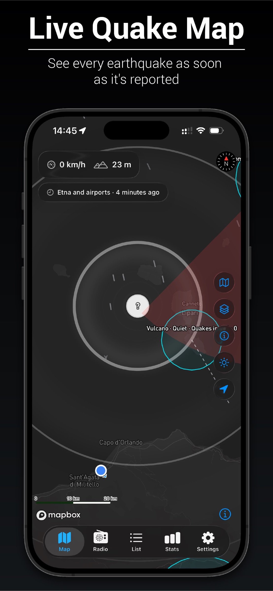
Every earthquake reported by INGV, EMSC and USGS appears on the map as soon as it is published, coloured by magnitude. For a recent quake, rings show how far it could have been felt. Filter by time, magnitude and distance, or browse them all in a list.
FIVE VOLCANOES, WATCHED
Etna, Stromboli, Vulcano, Campi Flegrei and Vesuvio each have a ring that shows their seismic unrest compared with the past month. For Etna and Stromboli you also see the official aviation colour code issued by INGV, with the observers' own notice: what they see, the ash cloud, and when it was issued.
WHERE THE ASH GOES
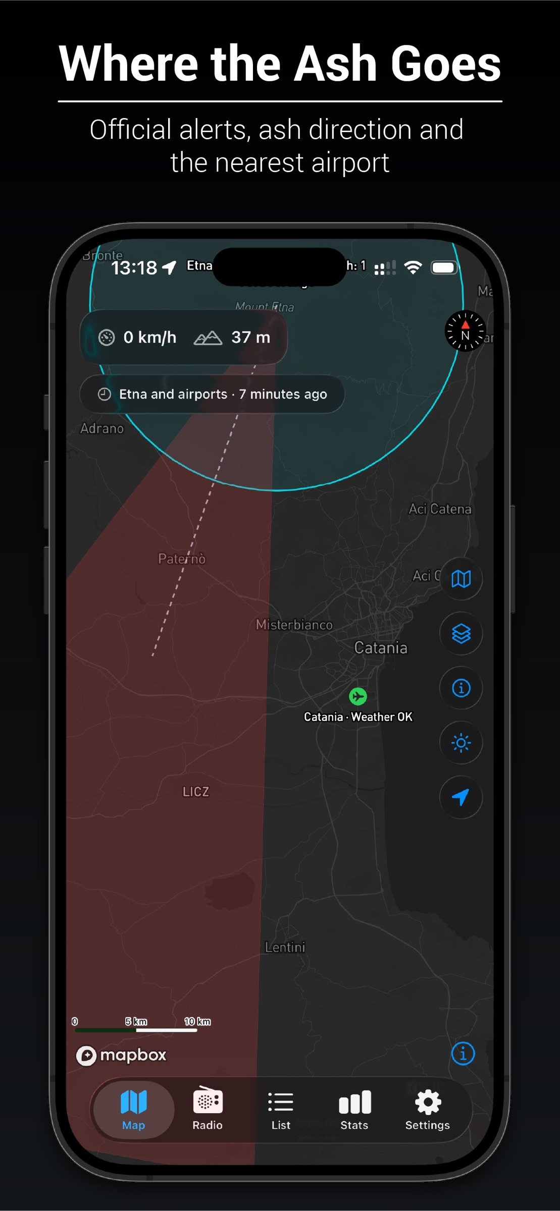
When the official code is Orange or Red, an ash cone points where the summit wind would carry it, towards Catania, Reggio Calabria or Naples.
AIRPORT WEATHER
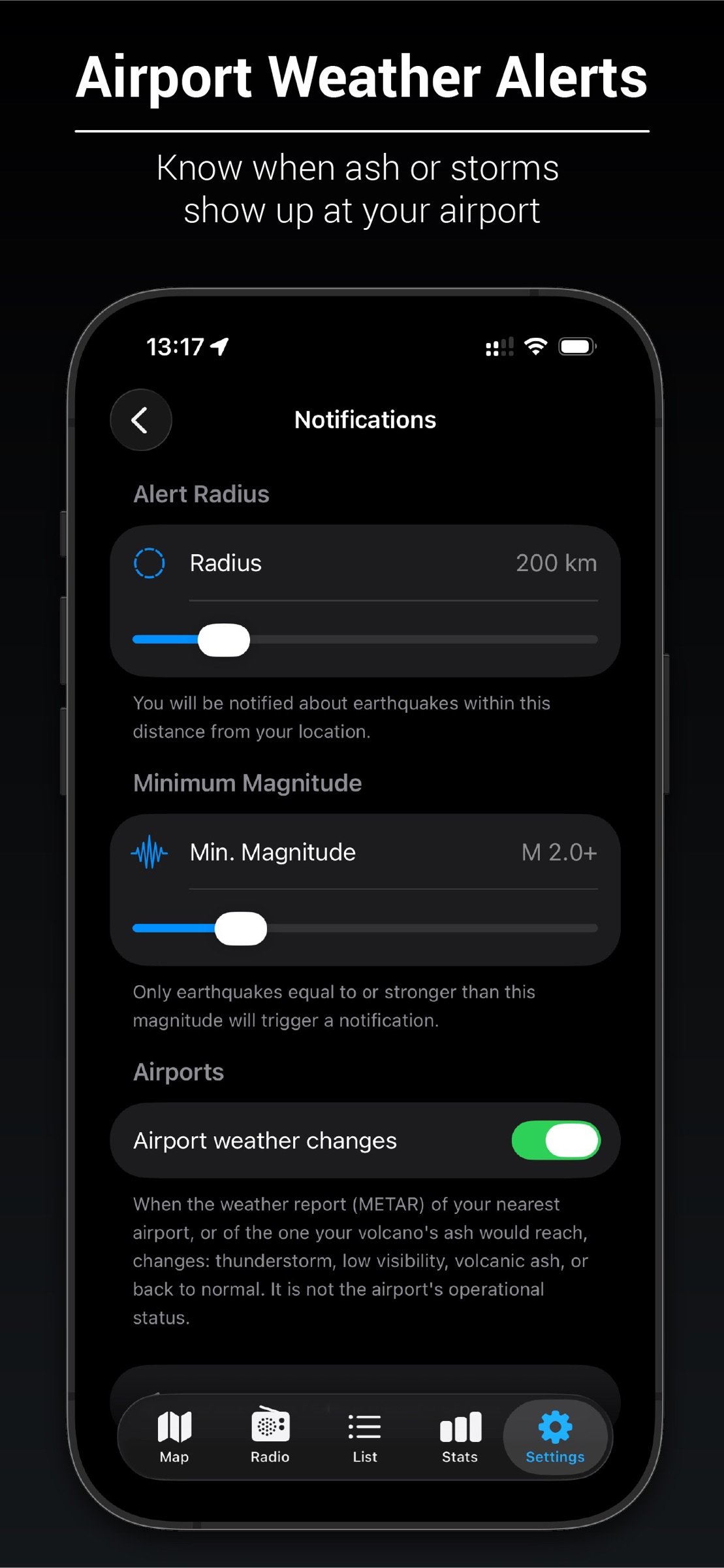
Catania, Comiso, Palermo, Trapani, Reggio Calabria and Naples, each coloured by its weather report: thunderstorm, low visibility, volcanic ash. Turn on alerts and your phone tells you when the weather changes at the airport that matters to you.
WIND AND STORMS
Drifting streaks show the wind over the island, and a purple glow marks thunderstorms before they reach you.
RADIO OF SICILY
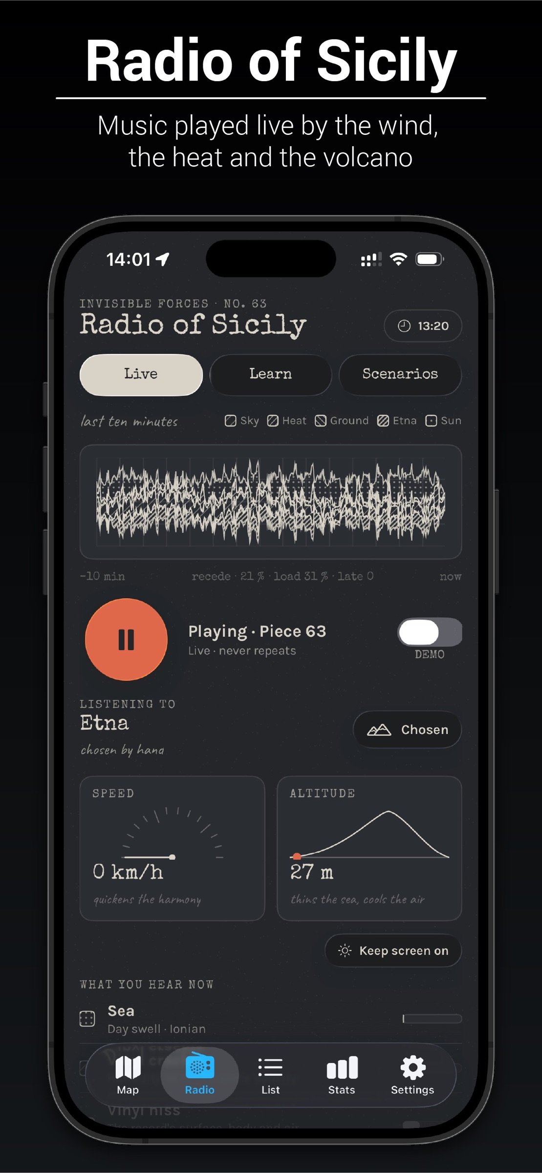
A piece of music that never repeats, played live by the forces around you. The wind strums an Aeolian harp. The heat wakes the cicadas, the evening wakes the crickets, and they call and answer each other. Birds sing at sunrise. Storms roll in as thunder. The volcano you listen to has its own voice: Etna's deep drone, Stromboli's bursts and sparks, the steam of Vulcano, the slow breath of Campi Flegrei. Climb a mountain and the sea fades as the air thins and a shimmer of bells appears. Drive and the harmony quickens. It keeps playing with the screen off.
LEARN WHY IT SOUNDS
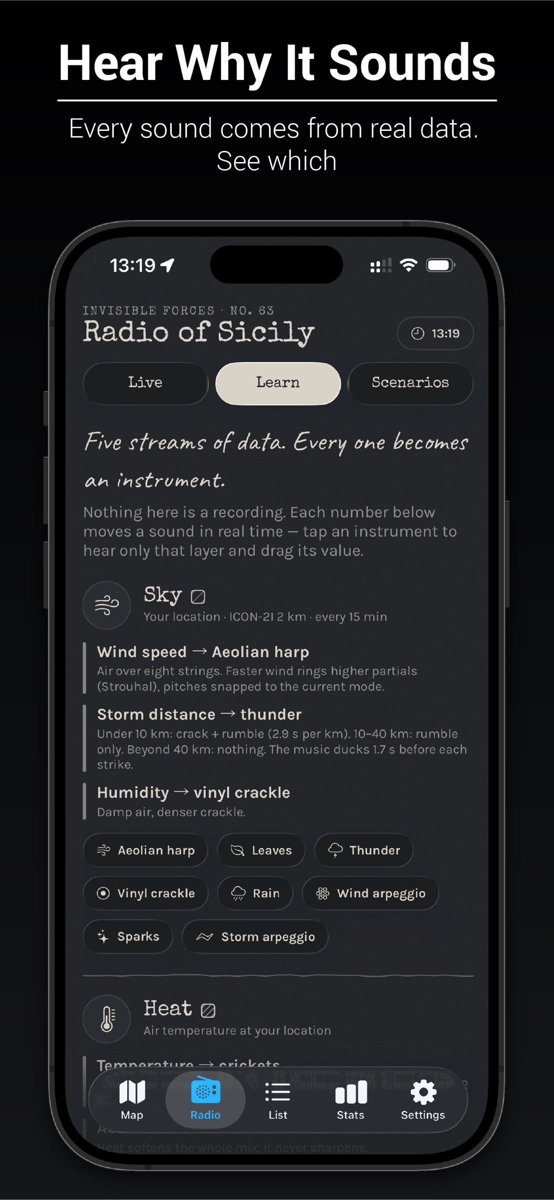
Every sound comes from real data, and the app shows you which: tap a layer to hear it alone and read what moves it. Or try Scenarios to hear a storm, an eruption or a quiet August night.
GUESS THE MAGNITUDE
Felt a tremor? For an hour Vulcana hides the magnitude of a quake near you. Guess it, see how close you were, build streaks and climb from Novice to Master Seismologist.
SPEED AND ALTITUDE
A speedometer and altimeter on the map and in the radio, with a button that keeps the screen on for a phone in a car holder.
PRIVATE BY DESIGN
No account, no ads, no tracking. Your precise location, speed and altitude never leave your iPhone. Only an area about 11 km across is used to look up the weather.
Please note: Vulcana is not an official warning system. It shows public scientific data as it is published, sometimes minutes late or later revised. For your safety, follow Civil Protection and INGV. Airport colours describe the weather, not whether flights operate.
Data: INGV, EMSC, USGS, MET Norway and NOAA. Maps © Mapbox © OpenStreetMap contributors.
Made by SIA SPACE, an audiovisual studio.
License: Commercial
Made for anyone who lives on, or travels to, the edge of an active volcano: Sicily, the Aeolian islands, Naples, Greece and the whole Mediterranean.
LIVE QUAKE MAP
Every earthquake reported by INGV, EMSC and USGS appears on the map as soon as it is published, coloured by magnitude. For a recent quake, rings show how far it could have been felt. Filter by time, magnitude and distance, or browse them all in a list.
FIVE VOLCANOES, WATCHED
Etna, Stromboli, Vulcano, Campi Flegrei and Vesuvio each have a ring that shows their seismic unrest compared with the past month. For Etna and Stromboli you also see the official aviation colour code issued by INGV, with the observers' own notice: what they see, the ash cloud, and when it was issued.
WHERE THE ASH GOES
When the official code is Orange or Red, an ash cone points where the summit wind would carry it, towards Catania, Reggio Calabria or Naples.
AIRPORT WEATHER
Catania, Comiso, Palermo, Trapani, Reggio Calabria and Naples, each coloured by its weather report: thunderstorm, low visibility, volcanic ash. Turn on alerts and your phone tells you when the weather changes at the airport that matters to you.
WIND AND STORMS
Drifting streaks show the wind over the island, and a purple glow marks thunderstorms before they reach you.
RADIO OF SICILY
A piece of music that never repeats, played live by the forces around you. The wind strums an Aeolian harp. The heat wakes the cicadas, the evening wakes the crickets, and they call and answer each other. Birds sing at sunrise. Storms roll in as thunder. The volcano you listen to has its own voice: Etna's deep drone, Stromboli's bursts and sparks, the steam of Vulcano, the slow breath of Campi Flegrei. Climb a mountain and the sea fades as the air thins and a shimmer of bells appears. Drive and the harmony quickens. It keeps playing with the screen off.
LEARN WHY IT SOUNDS
Every sound comes from real data, and the app shows you which: tap a layer to hear it alone and read what moves it. Or try Scenarios to hear a storm, an eruption or a quiet August night.
GUESS THE MAGNITUDE
Felt a tremor? For an hour Vulcana hides the magnitude of a quake near you. Guess it, see how close you were, build streaks and climb from Novice to Master Seismologist.
SPEED AND ALTITUDE
A speedometer and altimeter on the map and in the radio, with a button that keeps the screen on for a phone in a car holder.
PRIVATE BY DESIGN
No account, no ads, no tracking. Your precise location, speed and altitude never leave your iPhone. Only an area about 11 km across is used to look up the weather.
Please note: Vulcana is not an official warning system. It shows public scientific data as it is published, sometimes minutes late or later revised. For your safety, follow Civil Protection and INGV. Airport colours describe the weather, not whether flights operate.
Data: INGV, EMSC, USGS, MET Norway and NOAA. Maps © Mapbox © OpenStreetMap contributors.
Made by SIA SPACE, an audiovisual studio.
License: Commercial
| Release info | New Release on Oct 05, 2026 |
|---|---|
| Release notes | Terremoti is now Vulcana, and it has grown into something new. VOLCANOES • Five volcanoes watched: Etna, Stromboli, Vulcano, Campi Flegrei and Vesuvio, each with a ring of seismic unrest. • The official INGV aviation colour code for Etna and Stromboli, with the observers' notice and a link to it. • An ash cone that shows where the summit wind would carry the ash when the code is Orange or Red. AIRPORTS • Weather for Catania, Comiso, Palermo, Trapani, Reggio Calabria and Naples: thunderstorm, low visibility, volcanic ash. • New alerts when the weather changes at your nearest airport, or at the one your volcano's ash would reach. You can turn them off in Settings. MAP • Wind streaks that drift across the island, and storm cells before they arrive. • A Layers menu to show or hide volcano activity, volcano locations, airports, wind and the heat map. • A legend that explains every mark on the map. • A note that tells you when the volcano and airport data is out of date. • Speed and altitude on the map, updated smoothly. RADIO OF SICILY (NEW) • Generative music played live by the wind, the heat, storms, the time of day and the volcano. It never repeats. • Cicadas, crickets and birds that talk to each other, with pauses and answers. • A voice for each volcano. Choose one, or let Vulcana pick the nearest. • Your altitude and speed shape the music: the sea fades as you climb, the harmony quickens as you travel. • The day follows the real sunrise and sunset where you are. • Learn and Scenarios: see which data moves each sound, and hear the radio under other skies. AND • A button that keeps the screen on, for a phone in a car holder. • All seven languages completed. • Privacy policy, support and terms now at SIA SPACE. • Many fixes and improvements. |
| Listing data | App Store |
Reviews
No reviews yet. Be the first to review Vulcana.
Used Vulcana? Tell other visitors what you thought.
Log in to write a reviewOther products by this publisher
- "No Distractions" for YouTube 4.10 ----
- #Bible 11.6 "Incredible App - My sister shared this app with me a few weeks ago and it is truly incredible.
- #filmphotography 1.4.2 So, you decided to shoot on film?
- $quirrel 1.5.1 $quirrel Budget & Finance helps you plan each paycheck, track spending, manage debt, and see what is safe to spend before the next payday.
- % Percentage Calculator Pro 1.41 This is the Pro version of % Percentage Calculator.
Most viewed iOS Navigation
-
1
 Compass App 1.0.5
Find your direction with style.
-
2
 CARFACE Car Widgets & Lyrics 1.2.0
Make every drive feel more personal with CarFace.
-
3
 iGlide Lite 2.9.66
NaviLogic iGlide - the Soaring Navigation app for iOS
-
4
 Open Road 1.2
Open Road is the one driving app for your iPhone.
-
5
 Turo 26.45.0
Turo is a better car rental app for travelers who want to rent a car without the rental counter.
-
6
 Kruger Birding by Firefinch 7.6.0
Go birding in South Africa's foremost birding spot: the world renowned Kruger National Park!
-
7
 Amtrak 6.1.8
Discover the convenience of traveling with Amtrak.
-
8
 Fly Delta 7.17.3
Welcome to Fly Delta, Delta’s award winning iOS app.
-
9
 Uber 3.747.10000
Join the millions of riders who trust Uber for their everyday travel needs.
-
10
 Lyft 2026.43.3
Get where you’re going with Lyft.
Most downloaded iOS Navigation
-
1
 Live Traffic 2.4
Navigate the globe with live traffic updates, satellite views, and location tools that make every journey clearer, smarter, and more confident from the very first tap.
-
2
 Peru’s Best 2.5
PERU’S BEST is the ideal travel guide to this extraordinary country.
-
3
 Grand Egyptian Museum (GEM) 0.1.060
You could call this a coincidence but the acronym of the Grand Egyptian Museum is an apt title for the GEM, which is truly one!
-
4
 Pocket Luach Deluxe 60058
Pocket Luach Deluxe is a Jewish calendar, zmanim, Siddur, Tehillim, and personal-event companion for iPhone, iPad, and Apple Watch.
-
5
 Outdoor Photography Magazine 7.2.10
Outdoor Photography is the magazine for photographers who are passionate about being out in wild places, seeing inspiring nature and having great adventures.
-
6
 Passeporté 1.3.2
Passeporté reads the NFC chip in your biometric passport or national eID card, verifies its authenticity, and stores the data securely on your device.
-
7
 Great Circle Map 1.7.5
A globe you can turn in any direction, including straight over the poles.
-
8
 UK Map 4.12
* Unlimited free map downloads based on Ordnance Survey® OpenData, at 1:25,000 and 1:10,000 scales, and now also paid map downloads at 1:50,000, 1:25,000 and 1:10,000 scales, just like the paper maps.
-
9
 Cell Phone Towers World Map 1.1.6
219 countres !! The world's largest Database of Cell & Net Towers
-
10
 Connecticut-Parks & Trails 1.0
App Feature