
6downloads
1this week
FreeCommercial
0reviews
Screenshots
About TACNAV-X
---
What's up? This is Jon, the creator of TACNAV-X, an offline tactical navigation platform built for austere and contested environments.
I sincerely appreciate you taking the time to check out the app.
TACNAV-X is dedicated to the 24 Soldiers killed in action during our deployment to Afghanistan in 2010, and to the men and women who continue to serve today.
I'm still here, I'm still listening, and I'm still building.
God bless you,
Jon
---
KEY FEATURES:
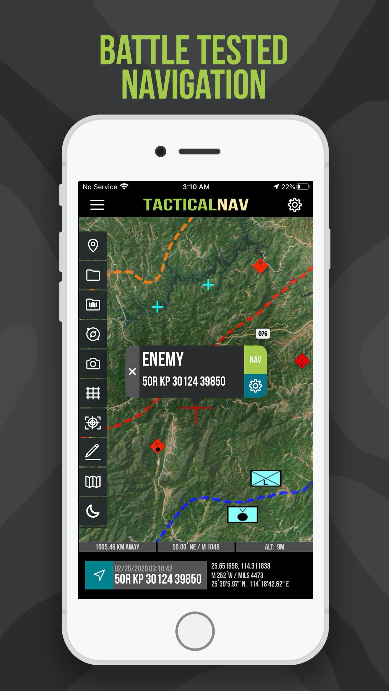
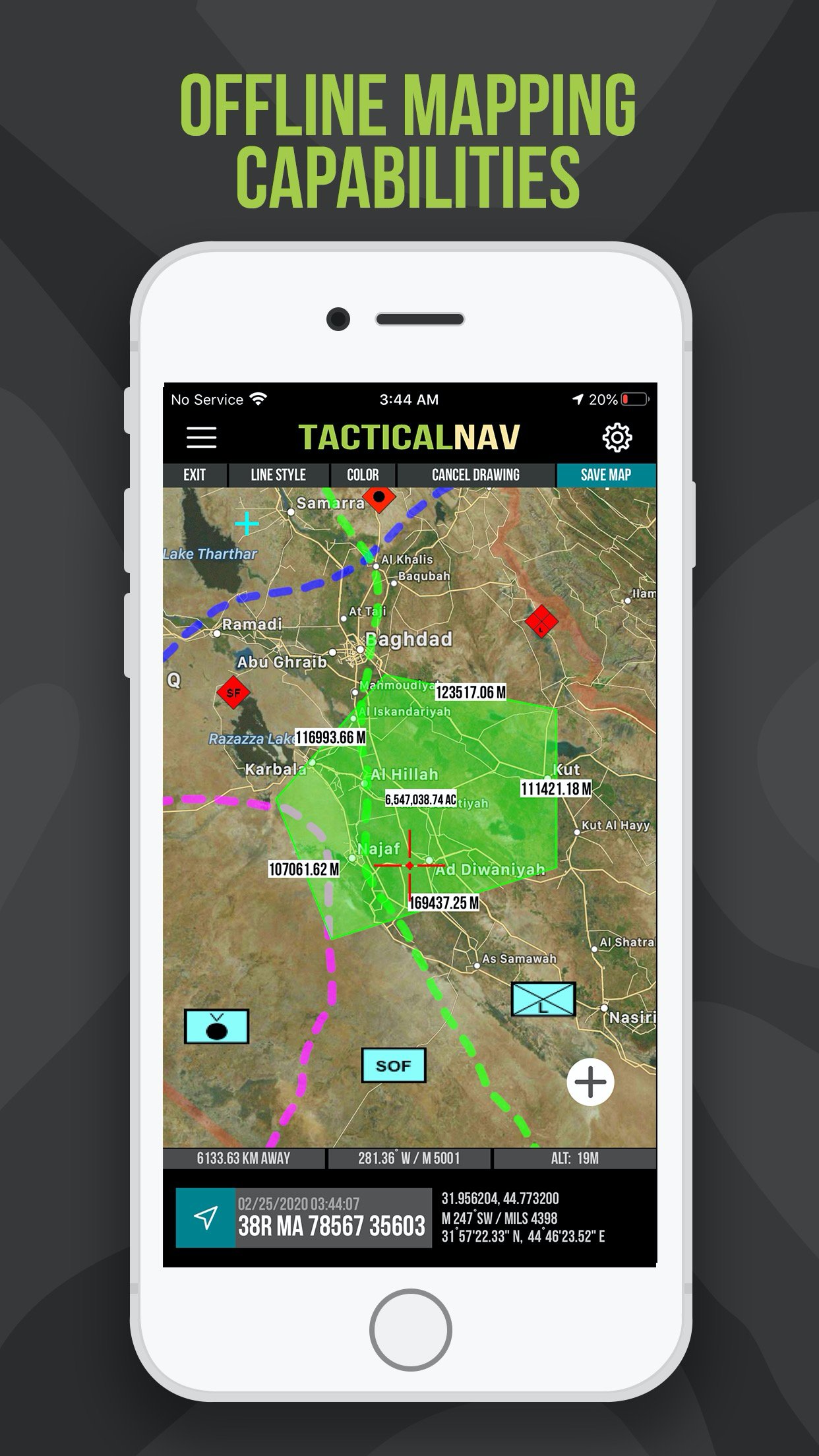
• Offline mapping capabilities (full app usage with no emission of a cellular signal)
• Purpose-built for the individual Soldier
• WGS-84 standard (MGRS, UTM, BNG, and USNG coordinates)
• A military-quality precision targeting platform
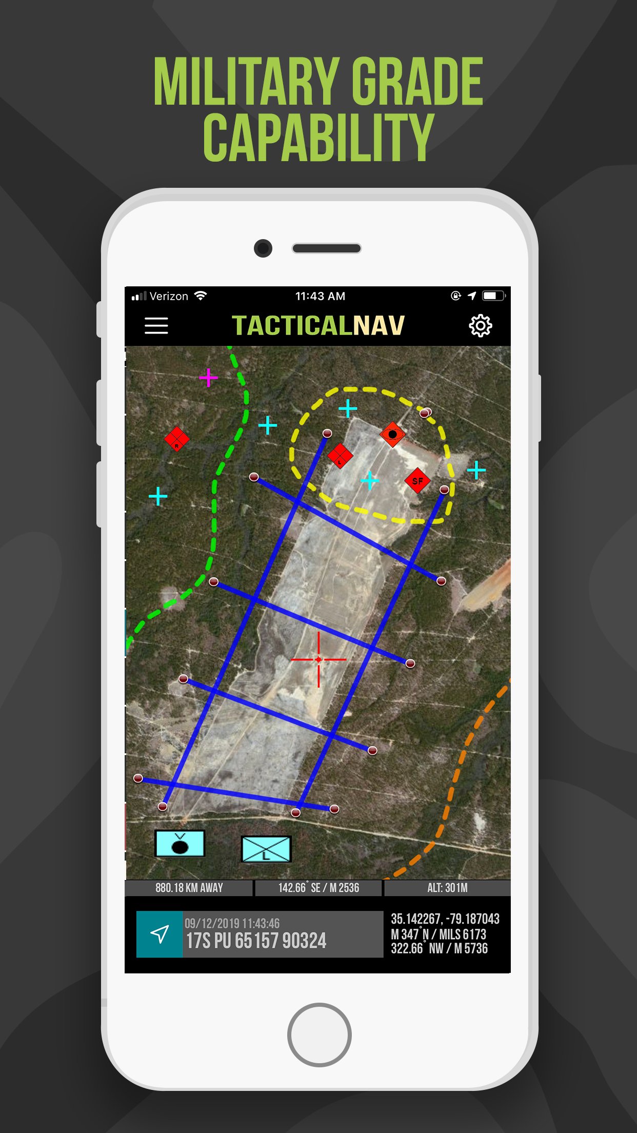
• Tactical drawing mode (useful for mission planning, building overlays, targeting, etc.)
• Waypoint plotting functionality with military graphics (per FM 1-02.2)
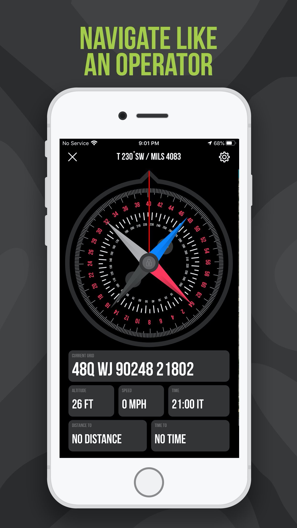
• Compass “FastLock” function for capturing quick and precise azimuths
• ‘Go to Grid’ feature for precision planning and targeting
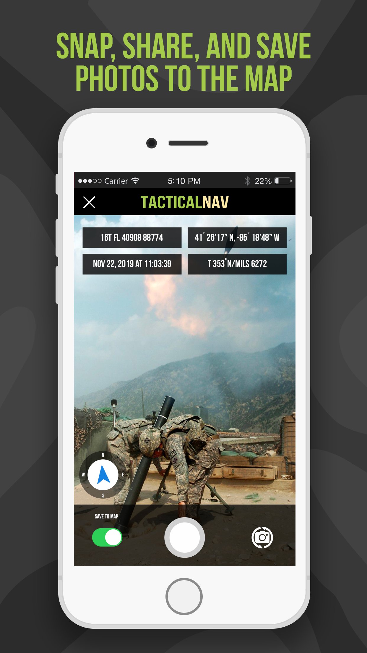
• Snap and save photographs onto the main map to increase situational awareness
• Location, waypoint, and photo-sharing capabilities (via email and text)
• One-button night mode function for low-light situations
• Apple Watch support included for free
BACKGROUND:
Built from the ground up in the rugged mountains of eastern Afghanistan, Tactical NAV (also known as TACNAV-X) was developed by a U.S. Army Field Artillery officer with the vision of crafting a low-cost and highly accurate mobile navigation platform tailored for the U.S. military.
Tactical NAV’s journey began in the Pech and Korengal Valleys of Kunar Province, Afghanistan.
U.S. Army Capt. Jonathan J. Springer, a Field Artilleryman serving as a Fire Support Officer with the 101st Airborne Division (Air Assault), began developing this tactical navigation platform immediately after the memorial services for Spc. Blair D. Thompson and Spc. Jared C. Plunk, who were killed in action on June 25, 2010.
Despite initial rejections by the Department of Defense, Captain Springer remained steadfast in his mission to continue developing TACNAV-X, even to this day.
He used his life savings to fund and develop TACNAV-X, all with the ultimate hope of saving military lives and helping his fellow service members accomplish their missions at home and abroad.
Tactical NAV officially launched on the App Store on February 14, 2011.
BUILT FOR ACCURACY:
TACNAV-X was extensively field-tested during military operations in Afghanistan and later at Fort Bragg, including comparative testing alongside the AN/PSN-13 Defense Advanced GPS Receiver (DAGR) and other military navigation systems.
MISSION:
Empower military service members with a highly accurate and powerful mobile navigation platform.
VISION:
Assist and support our nation’s service members with their mobile navigational needs and enable them to operate and win in both training and combat environments.
BOTTOM LINE:
Tactical NAV has undergone extensive real-world evaluation alongside Nett Warrior, ATAK, BFT, the DAGR, and other military targeting and navigation systems. During comparative testing, TACNAV-X demonstrated accuracy within 1 meter of a DAGR.
IAPs & SUBSCRIPTIONS:
Currently, offline mapping mode is available as a monthly or yearly subscription, or as a one-time purchase. Drawing mode, previously an in-app purchase, is now included free for all users.
All revenue generated from these features contributes to further development and updates, and a portion of the proceeds are donated to charities that specifically benefit disabled veterans.
IMPORTANT NOTES:
The Department of Defense does not endorse Tactical NAV or TACNAV-X. The app should not replace a government-issued device during life-threatening or combat operations.
SUPPORT:
If you have any questions about the app, please contact Jonathan Springer directly at jon@tacnavx.com.
License: Commercial
What's up? This is Jon, the creator of TACNAV-X, an offline tactical navigation platform built for austere and contested environments.
I sincerely appreciate you taking the time to check out the app.
TACNAV-X is dedicated to the 24 Soldiers killed in action during our deployment to Afghanistan in 2010, and to the men and women who continue to serve today.
I'm still here, I'm still listening, and I'm still building.
God bless you,
Jon
---
KEY FEATURES:
• Offline mapping capabilities (full app usage with no emission of a cellular signal)
• Purpose-built for the individual Soldier
• WGS-84 standard (MGRS, UTM, BNG, and USNG coordinates)
• A military-quality precision targeting platform
• Tactical drawing mode (useful for mission planning, building overlays, targeting, etc.)
• Waypoint plotting functionality with military graphics (per FM 1-02.2)
• Compass “FastLock” function for capturing quick and precise azimuths
• ‘Go to Grid’ feature for precision planning and targeting
• Snap and save photographs onto the main map to increase situational awareness
• Location, waypoint, and photo-sharing capabilities (via email and text)
• One-button night mode function for low-light situations
• Apple Watch support included for free
BACKGROUND:
Built from the ground up in the rugged mountains of eastern Afghanistan, Tactical NAV (also known as TACNAV-X) was developed by a U.S. Army Field Artillery officer with the vision of crafting a low-cost and highly accurate mobile navigation platform tailored for the U.S. military.
Tactical NAV’s journey began in the Pech and Korengal Valleys of Kunar Province, Afghanistan.
U.S. Army Capt. Jonathan J. Springer, a Field Artilleryman serving as a Fire Support Officer with the 101st Airborne Division (Air Assault), began developing this tactical navigation platform immediately after the memorial services for Spc. Blair D. Thompson and Spc. Jared C. Plunk, who were killed in action on June 25, 2010.
Despite initial rejections by the Department of Defense, Captain Springer remained steadfast in his mission to continue developing TACNAV-X, even to this day.
He used his life savings to fund and develop TACNAV-X, all with the ultimate hope of saving military lives and helping his fellow service members accomplish their missions at home and abroad.
Tactical NAV officially launched on the App Store on February 14, 2011.
BUILT FOR ACCURACY:
TACNAV-X was extensively field-tested during military operations in Afghanistan and later at Fort Bragg, including comparative testing alongside the AN/PSN-13 Defense Advanced GPS Receiver (DAGR) and other military navigation systems.
MISSION:
Empower military service members with a highly accurate and powerful mobile navigation platform.
VISION:
Assist and support our nation’s service members with their mobile navigational needs and enable them to operate and win in both training and combat environments.
BOTTOM LINE:
Tactical NAV has undergone extensive real-world evaluation alongside Nett Warrior, ATAK, BFT, the DAGR, and other military targeting and navigation systems. During comparative testing, TACNAV-X demonstrated accuracy within 1 meter of a DAGR.
IAPs & SUBSCRIPTIONS:
Currently, offline mapping mode is available as a monthly or yearly subscription, or as a one-time purchase. Drawing mode, previously an in-app purchase, is now included free for all users.
All revenue generated from these features contributes to further development and updates, and a portion of the proceeds are donated to charities that specifically benefit disabled veterans.
IMPORTANT NOTES:
The Department of Defense does not endorse Tactical NAV or TACNAV-X. The app should not replace a government-issued device during life-threatening or combat operations.
SUPPORT:
If you have any questions about the app, please contact Jonathan Springer directly at jon@tacnavx.com.
License: Commercial
| Release info | New Release on Oct 06, 2026 |
|---|---|
| Release notes | We’ve been listening closely to your feedback and are rebuilding Tactical NAV from the ground up for what’s next. What’s New: • Updated for iOS 27 • Next-Gen Hardware Support • Continued Swift Rebuild • Performance, Maintenance & Fixes This is just the beginning. A lot more is underway behind the scenes as we build the next generation of TACNAV-X. Stay tuned! Jon |
| Listing data | App Store |
Reviews
No reviews yet. Be the first to review TACNAV-X.
Used TACNAV-X? Tell other visitors what you thought.
Log in to write a reviewOther products by this publisher
- "No Distractions" for YouTube 4.10 ----
- #Bible 11.6 "Incredible App - My sister shared this app with me a few weeks ago and it is truly incredible.
- #filmphotography 1.4.2 So, you decided to shoot on film?
- $quirrel 1.5.1 $quirrel Budget & Finance helps you plan each paycheck, track spending, manage debt, and see what is safe to spend before the next payday.
- % Percentage Calculator Pro 1.41 This is the Pro version of % Percentage Calculator.
Most viewed iOS Navigation
-
1
 Compass App 1.0.5
Find your direction with style.
-
2
 CARFACE Car Widgets & Lyrics 1.2.0
Make every drive feel more personal with CarFace.
-
3
 iGlide Lite 2.9.66
NaviLogic iGlide - the Soaring Navigation app for iOS
-
4
 Open Road 1.2
Open Road is the one driving app for your iPhone.
-
5
 Turo 26.45.0
Turo is a better car rental app for travelers who want to rent a car without the rental counter.
-
6
 Kruger Birding by Firefinch 7.6.0
Go birding in South Africa's foremost birding spot: the world renowned Kruger National Park!
-
7
 Amtrak 6.1.8
Discover the convenience of traveling with Amtrak.
-
8
 Fly Delta 7.17.3
Welcome to Fly Delta, Delta’s award winning iOS app.
-
9
 Uber 3.747.10000
Join the millions of riders who trust Uber for their everyday travel needs.
-
10
 Lyft 2026.43.3
Get where you’re going with Lyft.
Most downloaded iOS Navigation
-
1
 Live Traffic 2.4
Navigate the globe with live traffic updates, satellite views, and location tools that make every journey clearer, smarter, and more confident from the very first tap.
-
2
 Peru’s Best 2.5
PERU’S BEST is the ideal travel guide to this extraordinary country.
-
3
 Grand Egyptian Museum (GEM) 0.1.060
You could call this a coincidence but the acronym of the Grand Egyptian Museum is an apt title for the GEM, which is truly one!
-
4
 Pocket Luach Deluxe 60058
Pocket Luach Deluxe is a Jewish calendar, zmanim, Siddur, Tehillim, and personal-event companion for iPhone, iPad, and Apple Watch.
-
5
 Outdoor Photography Magazine 7.2.10
Outdoor Photography is the magazine for photographers who are passionate about being out in wild places, seeing inspiring nature and having great adventures.
-
6
 Passeporté 1.3.2
Passeporté reads the NFC chip in your biometric passport or national eID card, verifies its authenticity, and stores the data securely on your device.
-
7
 Great Circle Map 1.7.5
A globe you can turn in any direction, including straight over the poles.
-
8
 UK Map 4.12
* Unlimited free map downloads based on Ordnance Survey® OpenData, at 1:25,000 and 1:10,000 scales, and now also paid map downloads at 1:50,000, 1:25,000 and 1:10,000 scales, just like the paper maps.
-
9
 Cell Phone Towers World Map 1.1.6
219 countres !! The world's largest Database of Cell & Net Towers
-
10
 Connecticut-Parks & Trails 1.0
App Feature