
Mountain Visibility Forecast 1.2.14
Some days you can't tell from the window whether the mountain is out or that's just bright gray sky.
Download
75.62 MB
11downloads
2this week
FreeCommercial
0reviews
Screenshots
About Mountain Visibility Forecast
Some days you can't tell from the window whether the mountain is out or that's just bright gray sky.
Mountain Visibility Forecast is an independent app made by MileCheck LLC. It is not a government app and does not represent NOAA, the National Weather Service, USGS, MET Norway, the National Park Service, the FAA, or any other agency.
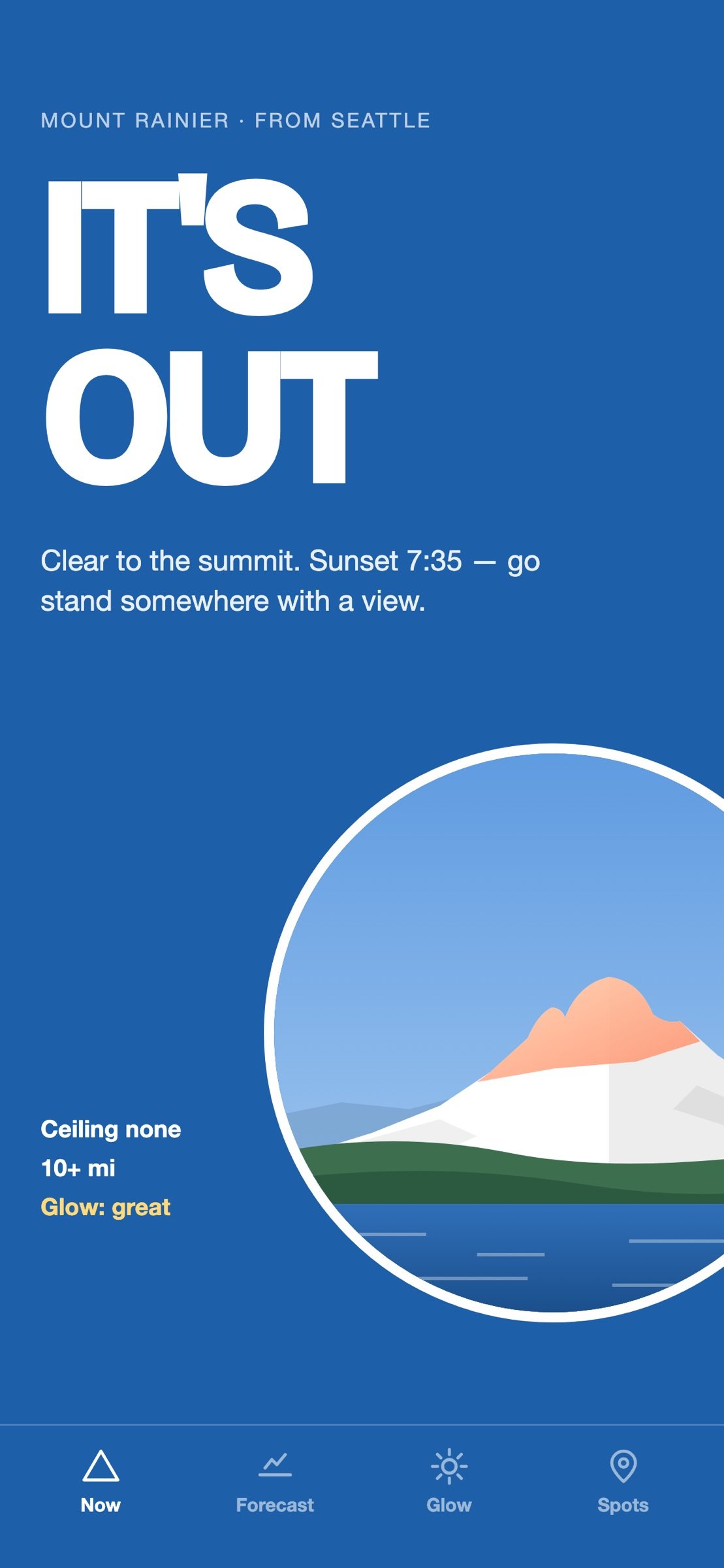
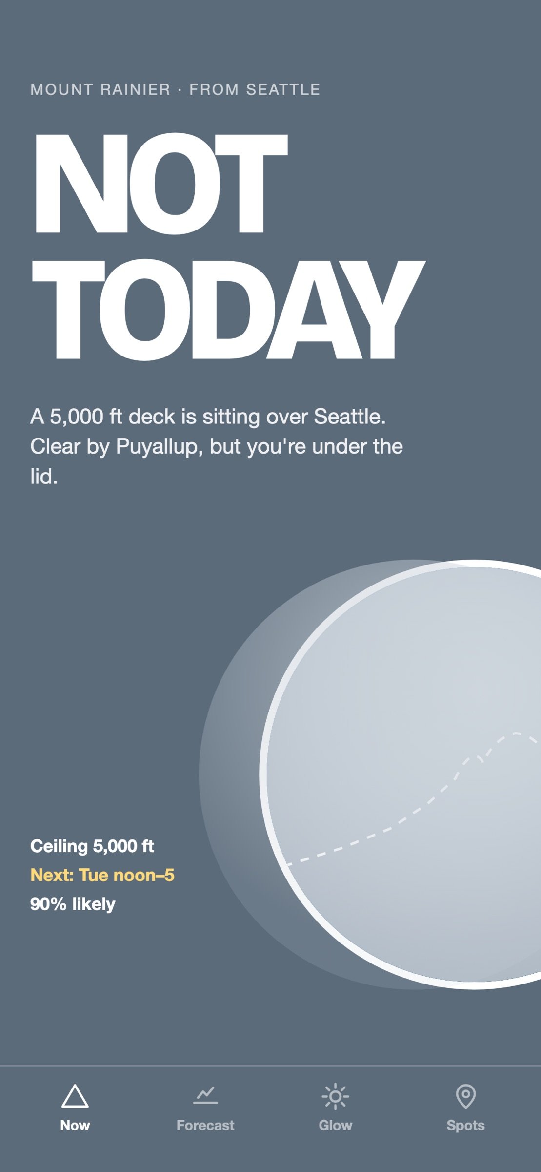
Open this and it says one thing: IT'S OUT, PARTLY OUT, or NOT TODAY. Under that, the reason. Cloud height over you, whether the summit is in cloud, how far you can see, whether wildfire smoke has drifted in.
Eight mountains. Mount Rainier and the Olympics from Seattle, Mount Hood and Mount St. Helens from Portland, Mount Baker from Vancouver and Bellingham, Denali from Talkeetna, Mount Angeles from Port Angeles and the Strait, and Mount Baldy from Los Angeles. The app picks the nearest, or you pick.
The answer is computed, not collected. It reads aviation weather from the airports along your line of sight to the summit, and the cloud layers at the summit itself from the MET Norway model.
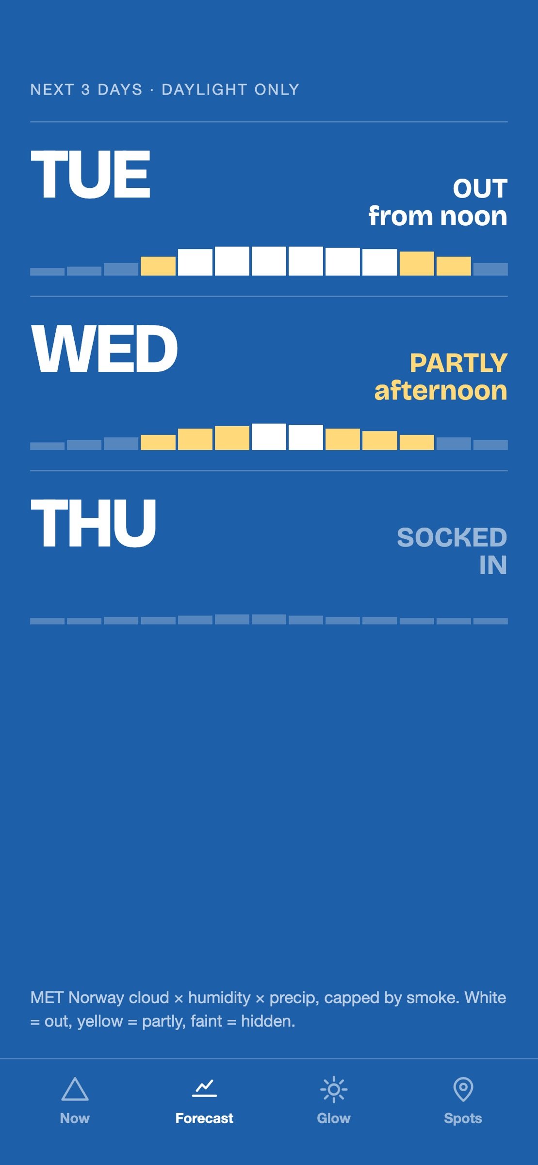
It tells you about the next five days, not just this minute. Hourly at first, then in six-hour steps.
You pay once. No subscription, no ads, nothing to unlock later. It collects nothing about you.
Where you are changes the answer, so that is built in. A Tacoma reading uses Tacoma's own overhead cloud and its 42-mile sightline, not Seattle's 60. On the morning you're the one clouded in, it tells you who isn't: "It's out from Tacoma, 26 miles off."
WHAT'S IN IT
Now. The verdict for your part of the region, with the reason underneath. Fifty-three regions across the eight mountains.
Forecast. The next five days, daylight hours.
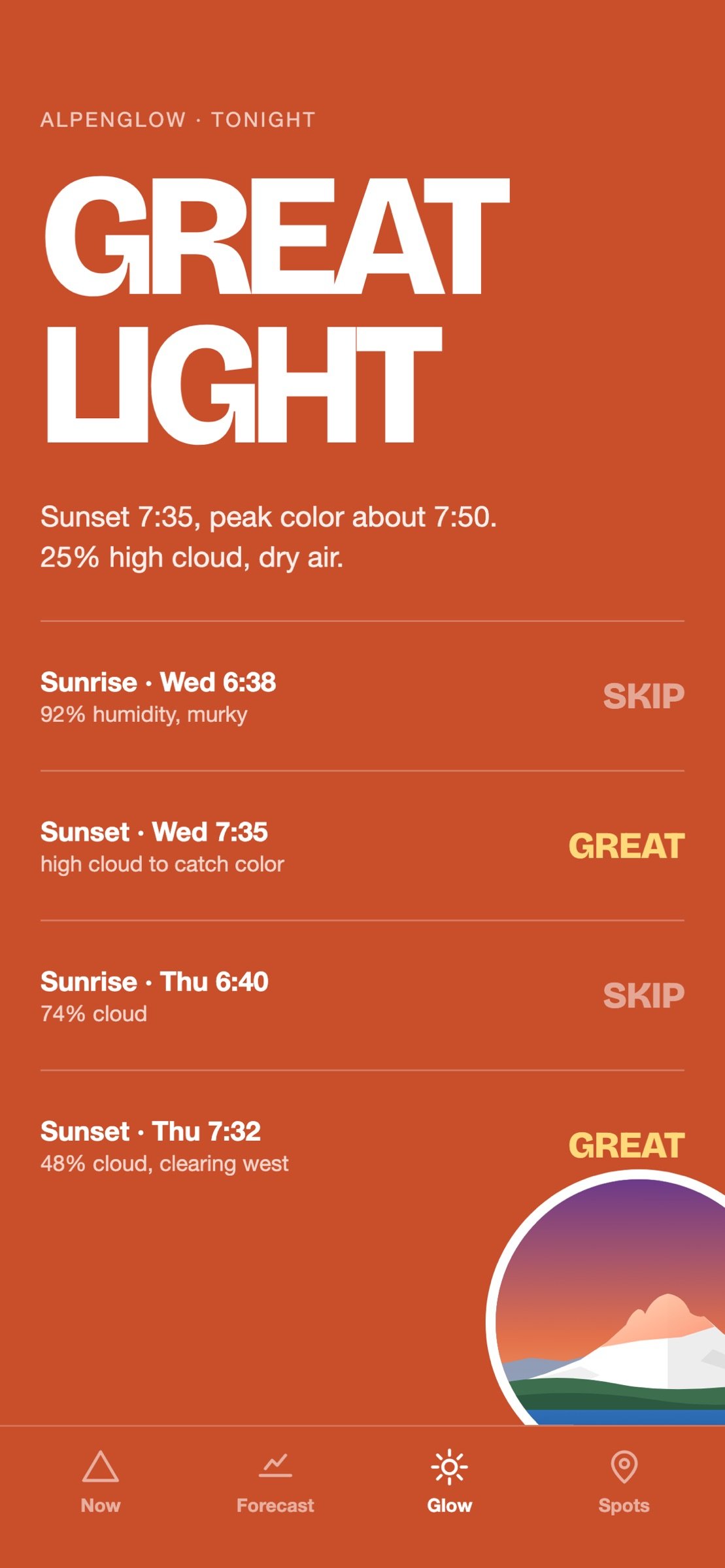
Glow. Every upcoming sunrise and sunset, graded. It splits cloud by height, because a low deck hides the mountain and high cloud catches the color. When the summit is in cloud, the grade is Skip.
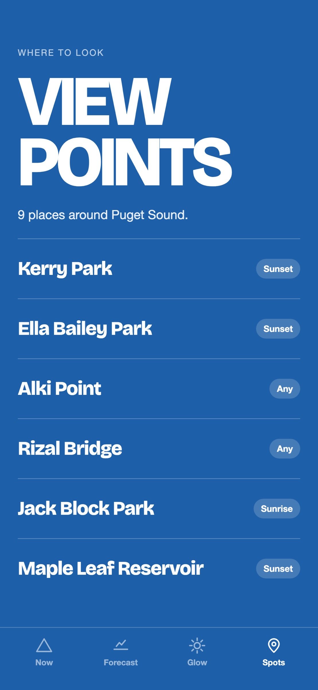
Spots. Viewpoints for each mountain, each with the reading from its nearest stations, sorted by distance from you, tap for directions.
Volcano status. The current USGS alert level for Rainier, Hood, Baker and St. Helens.
Settings. Alerts on or off for each mountain. Two a day at most, nothing between 10 PM and 6 AM, and only while the sun is up.
After dark it tells you when first light is.
Notifications are optional and rare, never at night. There is no account, anywhere.
CAMERAS
Rainier, the Olympics, Mount Angeles, St. Helens and Denali have webcam images on the Now screen from the National Park Service and the USGS Cascades Volcano Observatory. Denali's is an FAA weather camera that the National Park Service serves. Hood has three ODOT road cameras and Baldy a Caltrans camera. Each links to its source. Baker has none yet.
WHAT IT ISN'T
This is a forecast. It reads instruments and models and gives you a read of the sky between you and the mountain, and some days it will be wrong. Denali is the hardest of the eight: airport instruments stop measuring cloud around 12,000 feet, and the summit is 20,310. Above that line the app is reading a model, and it says so.
PRIVACY
One thing leaves your phone: a push token, so a notification can find you. It is not linked to you and it is not used to track you. If you tap "Use my location," your location is used on the phone to pick the mountain and the region, and never leaves it.
WHERE THE DATA COMES FROM
Aviation weather from the NOAA Aviation Weather Center, including NAV CANADA stations.
[link removed]
Forecast from MET Norway (CC BY 4.0).
[link removed]
Wildfire smoke from National Weather Service air quality guidance.
[link removed]
Volcano alert levels from the USGS Volcano Hazards Program.
[link removed]
Webcams from the National Park Service ([link removed]), the USGS Cascades Volcano Observatory ([link removed]), ODOT TripCheck and Caltrans.
License: Commercial
Mountain Visibility Forecast is an independent app made by MileCheck LLC. It is not a government app and does not represent NOAA, the National Weather Service, USGS, MET Norway, the National Park Service, the FAA, or any other agency.
Open this and it says one thing: IT'S OUT, PARTLY OUT, or NOT TODAY. Under that, the reason. Cloud height over you, whether the summit is in cloud, how far you can see, whether wildfire smoke has drifted in.
Eight mountains. Mount Rainier and the Olympics from Seattle, Mount Hood and Mount St. Helens from Portland, Mount Baker from Vancouver and Bellingham, Denali from Talkeetna, Mount Angeles from Port Angeles and the Strait, and Mount Baldy from Los Angeles. The app picks the nearest, or you pick.
The answer is computed, not collected. It reads aviation weather from the airports along your line of sight to the summit, and the cloud layers at the summit itself from the MET Norway model.
It tells you about the next five days, not just this minute. Hourly at first, then in six-hour steps.
You pay once. No subscription, no ads, nothing to unlock later. It collects nothing about you.
Where you are changes the answer, so that is built in. A Tacoma reading uses Tacoma's own overhead cloud and its 42-mile sightline, not Seattle's 60. On the morning you're the one clouded in, it tells you who isn't: "It's out from Tacoma, 26 miles off."
WHAT'S IN IT
Now. The verdict for your part of the region, with the reason underneath. Fifty-three regions across the eight mountains.
Forecast. The next five days, daylight hours.
Glow. Every upcoming sunrise and sunset, graded. It splits cloud by height, because a low deck hides the mountain and high cloud catches the color. When the summit is in cloud, the grade is Skip.
Spots. Viewpoints for each mountain, each with the reading from its nearest stations, sorted by distance from you, tap for directions.
Volcano status. The current USGS alert level for Rainier, Hood, Baker and St. Helens.
Settings. Alerts on or off for each mountain. Two a day at most, nothing between 10 PM and 6 AM, and only while the sun is up.
After dark it tells you when first light is.
Notifications are optional and rare, never at night. There is no account, anywhere.
CAMERAS
Rainier, the Olympics, Mount Angeles, St. Helens and Denali have webcam images on the Now screen from the National Park Service and the USGS Cascades Volcano Observatory. Denali's is an FAA weather camera that the National Park Service serves. Hood has three ODOT road cameras and Baldy a Caltrans camera. Each links to its source. Baker has none yet.
WHAT IT ISN'T
This is a forecast. It reads instruments and models and gives you a read of the sky between you and the mountain, and some days it will be wrong. Denali is the hardest of the eight: airport instruments stop measuring cloud around 12,000 feet, and the summit is 20,310. Above that line the app is reading a model, and it says so.
PRIVACY
One thing leaves your phone: a push token, so a notification can find you. It is not linked to you and it is not used to track you. If you tap "Use my location," your location is used on the phone to pick the mountain and the region, and never leaves it.
WHERE THE DATA COMES FROM
Aviation weather from the NOAA Aviation Weather Center, including NAV CANADA stations.
[link removed]
Forecast from MET Norway (CC BY 4.0).
[link removed]
Wildfire smoke from National Weather Service air quality guidance.
[link removed]
Volcano alert levels from the USGS Volcano Hazards Program.
[link removed]
Webcams from the National Park Service ([link removed]), the USGS Cascades Volcano Observatory ([link removed]), ODOT TripCheck and Caltrans.
License: Commercial
| Release info | Update on Oct 17, 2026 |
|---|---|
| Release notes | Five-day forecast. The later days are drawn in six-hour steps and say so. Public webcam images on the Now screen. NPS, USGS and FAA cameras for Rainier, the Olympics, Mount Angeles, St. Helens and Denali. ODOT cameras for Hood. A Caltrans camera for Baldy. A photo of the mountain on the Now screen for seven of the eight mountains, public domain and credited. Mount Baldy, read from Los Angeles and six other places. Chinook Pass, Sunrise and Paradise read the forecast at their own elevation. Pick one by name, or stand within two miles of it. Yakima, Olympia, Tacoma and Everett read Rainier along their own line of sight, with their own sunrise and sunset. Mount Baker: viewpoints around Seattle, Everett, Bellingham and Anacortes, each checked against the terrain. The place you read from is a button beside the mountain, and "Use my location" is always there. "Look southeast · 61 mi" under the verdict says which way to face. Every viewpoint row shows its direction. Settings: switch alerts on or off for each mountain. After dark the headline reads DARK NOW with the time of first light. A tall summit standing above a band of low cloud now reads as out, with "the lower slopes are in cloud." It used to read as hidden. An hour the forecast could not read is drawn as an outline, never as a verdict. From Olympia and Tacoma, a note when the moon sits behind the summit. |
| Listing data | App Store |
Reviews
No reviews yet. Be the first to review Mountain Visibility Forecast.
Used Mountain Visibility Forecast? Tell other visitors what you thought.
Log in to write a reviewOther products by this publisher
- "No Distractions" for YouTube 4.10 ----
- #Bible 11.6 "Incredible App - My sister shared this app with me a few weeks ago and it is truly incredible.
- #filmphotography 1.4.2 So, you decided to shoot on film?
- $quirrel 1.5.1 $quirrel Budget & Finance helps you plan each paycheck, track spending, manage debt, and see what is safe to spend before the next payday.
- % Percentage Calculator Pro 1.41 This is the Pro version of % Percentage Calculator.
Most viewed iOS Weather
-
1
 MesoRadar 1.6.0
MesoRadar is a Level 2 NEXRAD radar app for storm spotters, chasers and weather hobbyists.
-
2
 METAR Widgets 1.9
What better way to keep abreast of current conditions than with a beautiful METAR widget, right on your home screen?
-
3
 MeteoSwiss 3.6.1
Intuitive, personalised and innovative: the MeteoSwiss app is your comprehensive companion for all weather information in Switzerland – compact and always up to date.
-
4
 Wildfire Tracker—Live Fire Map 3.1.0
The Wildfire Tracker: wildfire maps, weather forecasts and air quality information for life in the US and your travels abroad.
-
5
 Weather UAE 4.1.30
The National Center of Meteorology, a UAE federal government entity has developed this Mobile application as an additional way of communicating and serving its clients through providing a continuous informational multi-view feed on high-resolution w…
-
6
 Firespot 6.1
Firespot is the most comprehensive source of real-time wildfire data.
-
7
 WeatherLCD 25.0
Why pay for multiple apps that provide U.S.
-
8
 HF Weather Fax 1.6
Do you want to get your weather charts without using an internet connection or a dedicated computer?
-
9
 Tide Times 3.2
Tide Times offers a simple and accurate 7-day forecast for UK tidal time.
-
10
 WeatherBug 6.10.1
A brand-new WeatherBug is here!
Most downloaded iOS Weather
-
1
HF Weather Fax 1.6
Do you want to get your weather charts without using an internet connection or a dedicated computer?
-
2
 Windfinder 5.43.0
Detailed wind and weather forecasts for your location.
- 3 (Not Boring) Weather 3.54 ~ WEATHER DOESN’T HAVE TO BE BORING ~
-
4
 Radar HD Future Weather Radar 2.0
Fast. Simple. Predictive high-resolution Weather Radar.
-
5
WeatherBug 6.10.1
A brand-new WeatherBug is here!
-
6
 OpenSnow 8.5.0
OpenSnow is your trusted source for the most accurate snow forecast, snow report, and ski conditions.
-
7
 GoNoGo 3.1.3
GoNoGo gives you a clear FAVORABLE, MARGINAL, or NO-GO recommendation for your route — not just raw data to interpret yourself.
-
8
 Moonlitt 2.10.1
#1 Moon Tracker App • Apple Design Award 2026 Winner • App of the Day • Great on iOS 26
-
9
 MCWX 8.0.0
After 23 years covering Eastern Oklahoma Weather, Chief Meteorologist Mike Collier is releasing a state of the art weather app to help continue to keep Oklahomans safe.
-
10
 Tidal Arc 1.0
The tide doesn't wait.