MGRS & UTM GPS Maps PRO 5.0.2.20
MGRS & UTM GPS Maps PRO is a professional navigation and field-management solution that brings coordinate-grade precision to real-world conditions.
Download
38.49 MB
0downloads
0this week
FreeCommercial
0reviews
Screenshots
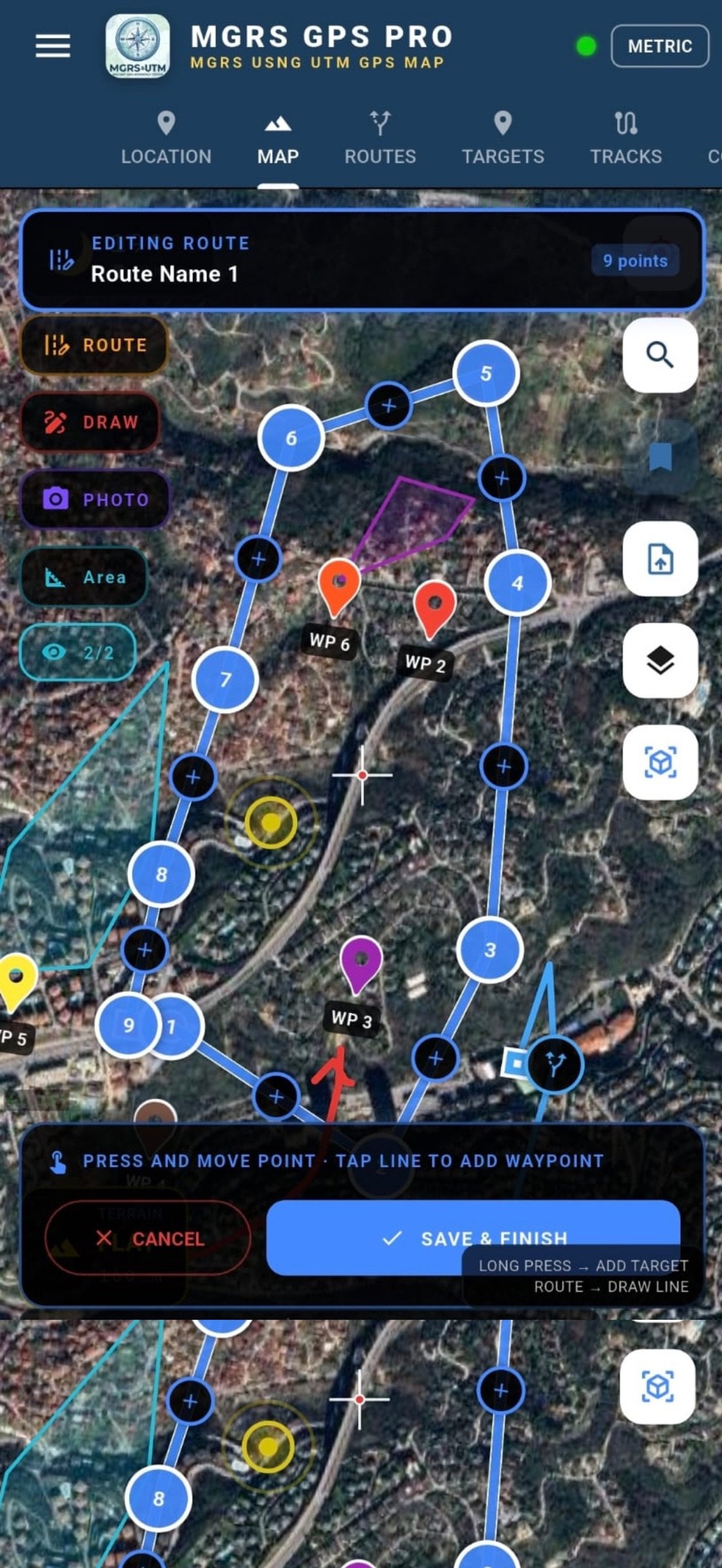
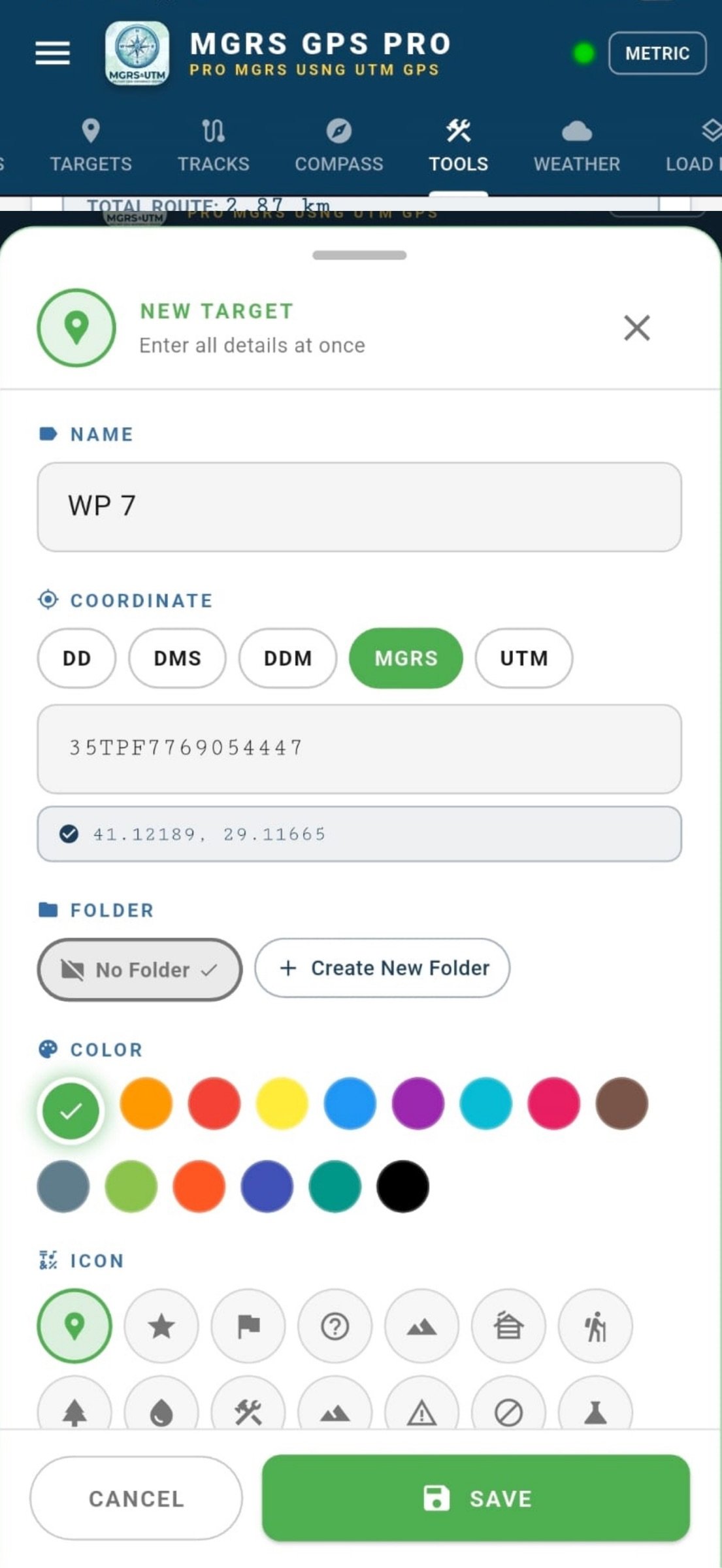
About MGRS & UTM GPS Maps PRO
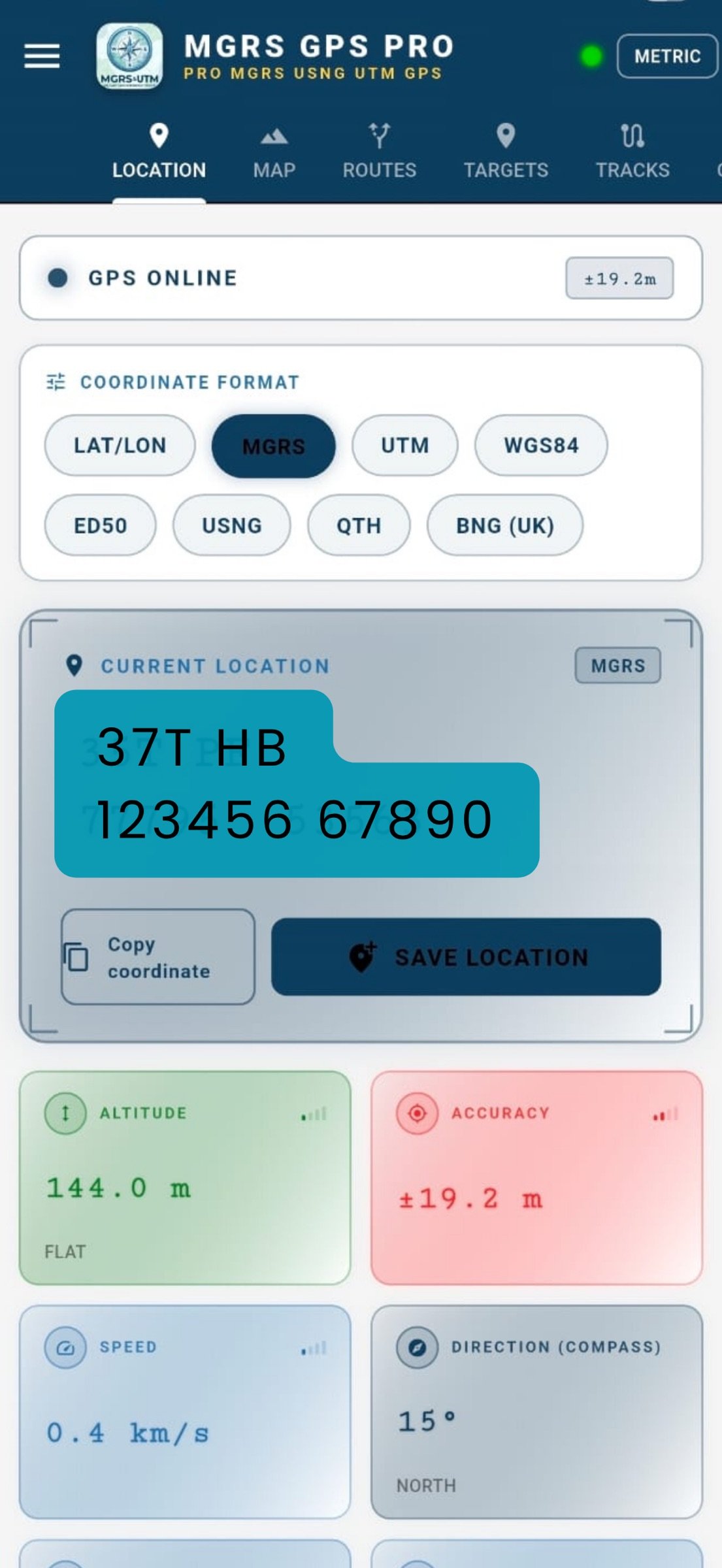
MGRS & UTM GPS Maps PRO is a professional navigation and field-management solution that brings coordinate-grade precision to real-world conditions. From military personnel and mapping engineers to search-and-rescue teams and off-road drivers, it is trusted on any mission where location matters. No internet connection, account, or cloud sign-in is required -- it works the moment you open it, in 32 languages.
? COORDINATE & GRID SYSTEMS
Read any single point in the system you need and switch between them instantly:
- MGRS (Military Grid Reference System), USNG and UTM
- QTH and decimal LAT/LON
- WGS84 and ED50 datum options
- DTG (Date-Time Group) time display (Zulu + local)
- MGRS grid lines overlaid on the map
- Real-time conversion across all systems
? MAPS & OFFLINE USE
Download before you head out, use it beyond coverage:
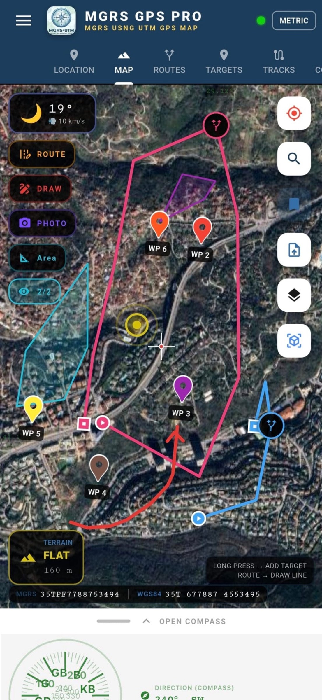
- Satellite, hybrid, topographic and road layers (default: high-resolution satellite)
- Contour (isohypse) and shaded-relief views
- Region-based offline map downloads
- Your own maps: MBTiles, GeoTIFF, GeoPDF, GeoPackage
- Automatic georeferencing of geospatial PDF/TIFF files
- 3D terrain view and elevation profile
? TARGETS & LIVE GUIDANCE
- Create and manage unlimited waypoints
- Enter targets by MGRS coordinate or by tapping the map
- Live distance, bearing and ETA to the selected target
- Attach photos to points for visual records
- Share a target in seconds via deep link
? ROUTE PLANNING & TRACK LOGGING
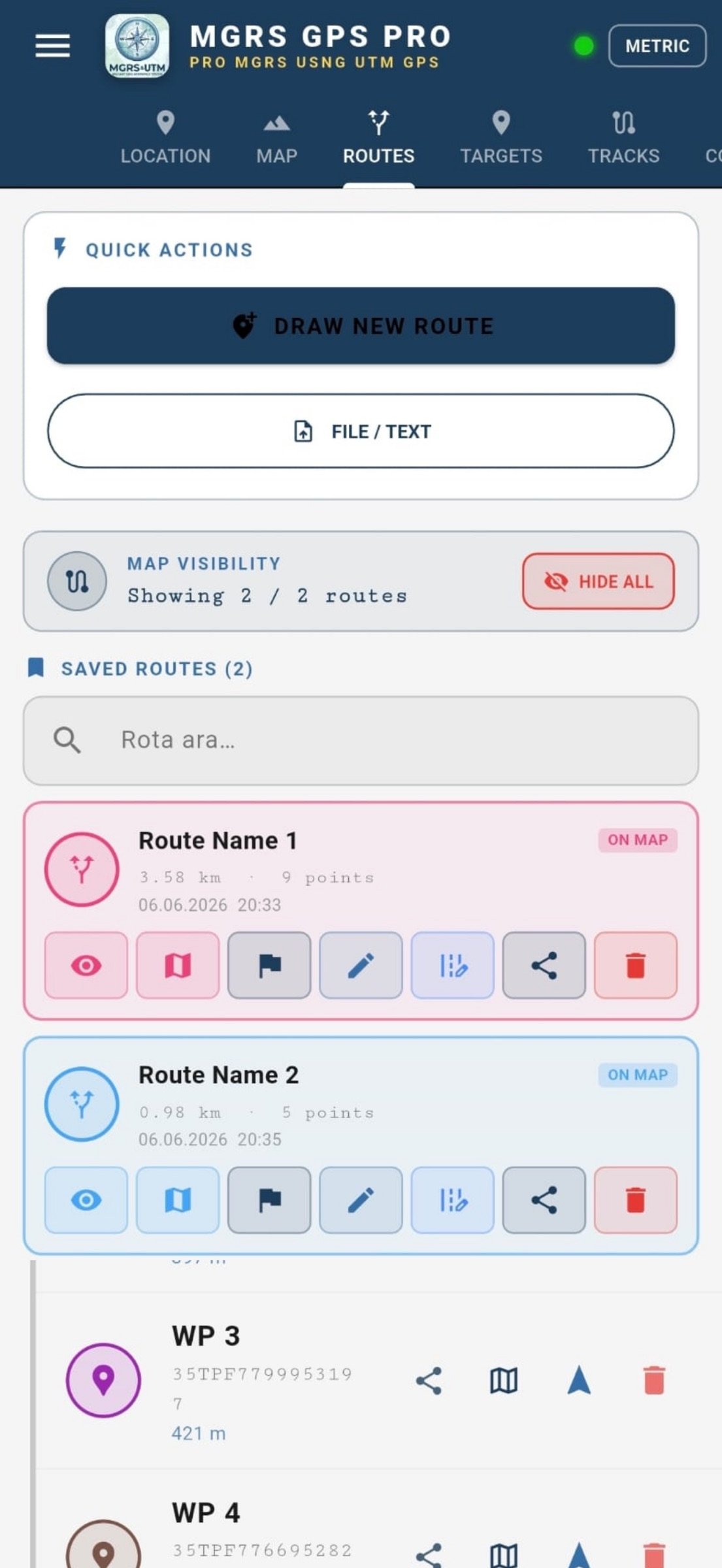
- Multi-point route drawing with full editing (move/delete/add)
- Fine-tuning of segment waypoints
- Active navigation mode with off-route deviation alerts
- Uninterrupted background track recording
- Speed, distance, elevation and total ascent/descent stats
- Reuse a saved track as a route
- Precise digital compass and deviation indicator
? MEASUREMENT, AREA & ANALYSIS
- Draw, edit and calculate areas with polygons (m2 / km2 / acre / hectare)
- Auto-import areas from cadastre-compatible KML
- Distance measuring tool
- Coordinate converter (LAT/LON MGRS UTM)
- Elevation and slope analysis
- Freehand briefing drawing on the map
- Weather information and offline cache management
? DATA EXCHANGE
- Import/export GPX, KML, KMZ and GeoJSON
- Point, LineString, Polygon and MultiGeometry support
- Open files directly from messaging, email or your file manager
- Smart format detection -- files are routed to the right tab automatically
- Share routes and tracks as GPX/KML
? DATA SECURITY & PRIVACY
Your location, targets and routes stay on your device only. No data is ever sent to a server -- the foundation of operational security (OPSEC) for sensitive missions.
? 32 LANGUAGES
Turkish, English, German, French, Spanish, Italian, Dutch, Portuguese, Polish, Norwegian, Bulgarian, Croatian, Lithuanian, Romanian, Slovak, Slovenian, Ukrainian, Chinese, Japanese, Korean, Hindi, Indonesian, Malay, Thai, Filipino, Arabic, Persian, Russian, Azerbaijani, Kazakh, Uzbek and Afrikaans.
? WHO IT'S FOR
Military and tactical movement . geology and mapping engineering . mineral exploration and drilling . cadastral field verification . search and rescue . mountaineering, hunting and off-road.
License: Commercial
? COORDINATE & GRID SYSTEMS
Read any single point in the system you need and switch between them instantly:
- MGRS (Military Grid Reference System), USNG and UTM
- QTH and decimal LAT/LON
- WGS84 and ED50 datum options
- DTG (Date-Time Group) time display (Zulu + local)
- MGRS grid lines overlaid on the map
- Real-time conversion across all systems
? MAPS & OFFLINE USE
Download before you head out, use it beyond coverage:
- Satellite, hybrid, topographic and road layers (default: high-resolution satellite)
- Contour (isohypse) and shaded-relief views
- Region-based offline map downloads
- Your own maps: MBTiles, GeoTIFF, GeoPDF, GeoPackage
- Automatic georeferencing of geospatial PDF/TIFF files
- 3D terrain view and elevation profile
? TARGETS & LIVE GUIDANCE
- Create and manage unlimited waypoints
- Enter targets by MGRS coordinate or by tapping the map
- Live distance, bearing and ETA to the selected target
- Attach photos to points for visual records
- Share a target in seconds via deep link
? ROUTE PLANNING & TRACK LOGGING
- Multi-point route drawing with full editing (move/delete/add)
- Fine-tuning of segment waypoints
- Active navigation mode with off-route deviation alerts
- Uninterrupted background track recording
- Speed, distance, elevation and total ascent/descent stats
- Reuse a saved track as a route
- Precise digital compass and deviation indicator
? MEASUREMENT, AREA & ANALYSIS
- Draw, edit and calculate areas with polygons (m2 / km2 / acre / hectare)
- Auto-import areas from cadastre-compatible KML
- Distance measuring tool
- Coordinate converter (LAT/LON MGRS UTM)
- Elevation and slope analysis
- Freehand briefing drawing on the map
- Weather information and offline cache management
? DATA EXCHANGE
- Import/export GPX, KML, KMZ and GeoJSON
- Point, LineString, Polygon and MultiGeometry support
- Open files directly from messaging, email or your file manager
- Smart format detection -- files are routed to the right tab automatically
- Share routes and tracks as GPX/KML
? DATA SECURITY & PRIVACY
Your location, targets and routes stay on your device only. No data is ever sent to a server -- the foundation of operational security (OPSEC) for sensitive missions.
? 32 LANGUAGES
Turkish, English, German, French, Spanish, Italian, Dutch, Portuguese, Polish, Norwegian, Bulgarian, Croatian, Lithuanian, Romanian, Slovak, Slovenian, Ukrainian, Chinese, Japanese, Korean, Hindi, Indonesian, Malay, Thai, Filipino, Arabic, Persian, Russian, Azerbaijani, Kazakh, Uzbek and Afrikaans.
? WHO IT'S FOR
Military and tactical movement . geology and mapping engineering . mineral exploration and drilling . cadastral field verification . search and rescue . mountaineering, hunting and off-road.
License: Commercial
| Release info | New Release on Jul 02, 2026 |
|---|---|
| Release notes | bug fixes |
| Listing data | App Store |
Reviews
No reviews yet. Be the first to review MGRS & UTM GPS Maps PRO.
Used MGRS & UTM GPS Maps PRO? Tell other visitors what you thought.
Log in to write a reviewOther products by this publisher
- "No Distractions" for YouTube 4.10 ----
- #Bible 11.5 "Incredible App - My sister shared this app with me a few weeks ago and it is truly incredible.
- #filmphotography 1.4.2 So, you decided to shoot on film?
- $quirrel 1.5.1 $quirrel Budget & Finance helps you plan each paycheck, track spending, manage debt, and see what is safe to spend before the next payday.
- % Percentage Calculator Pro 1.41 This is the Pro version of % Percentage Calculator.
Most viewed iOS Navigation
-
1
 Compass App 1.0.5
Find your direction with style.
-
2
 CARFACE Car Widgets & Lyrics 1.2.0
Make every drive feel more personal with CarFace.
-
3
 Turo 26.44.1
Turo is a better car rental app for travelers who want to rent a car without the rental counter.
-
4
 iGlide Lite 2.9.66
NaviLogic iGlide - the Soaring Navigation app for iOS
-
5
 Open Road 1.2
Open Road is the one driving app for your iPhone.
-
6
 Amtrak 6.1.8
Discover the convenience of traveling with Amtrak.
-
7
 Kruger Birding by Firefinch 7.2.0
Go birding in South Africa's foremost birding spot: the world renowned Kruger National Park!
-
8
 Lyft 2026.42.3
Get where you’re going with Lyft.
-
9
 Waymo 155
Get there with The World’s Most Experienced Driver™
-
10
 American Airlines 2026.33
With the American Airlines app, you’re covered with the information you need exactly when you need it.
Most downloaded iOS Navigation
-
1
 Live Traffic 2.4
Navigate the globe with live traffic updates, satellite views, and location tools that make every journey clearer, smarter, and more confident from the very first tap.
-
2
 Peru’s Best 2.5
PERU’S BEST is the ideal travel guide to this extraordinary country.
-
3
 Grand Egyptian Museum (GEM) 0.1.054
You could call this a coincidence but the acronym of the Grand Egyptian Museum is an apt title for the GEM, which is truly one!
-
4
 Pocket Luach Deluxe 60058
Pocket Luach Deluxe is a Jewish calendar, zmanim, Siddur, Tehillim, and personal-event companion for iPhone, iPad, and Apple Watch.
-
5
 Outdoor Photography Magazine 7.2.10
Outdoor Photography is the magazine for photographers who are passionate about being out in wild places, seeing inspiring nature and having great adventures.
-
6
 Great Circle Map 1.7.4
A globe you can turn in any direction, including straight over the poles.
-
7
 Passeporté 1.3.2
Passeporté reads the NFC chip in your biometric passport or national eID card, verifies its authenticity, and stores the data securely on your device.
-
8
 Cell Phone Towers World Map 1.1.6
219 countres !! The world's largest Database of Cell & Net Towers
-
9
 UK Map 4.12
* Unlimited free map downloads based on Ordnance Survey® OpenData, at 1:25,000 and 1:10,000 scales, and now also paid map downloads at 1:50,000, 1:25,000 and 1:10,000 scales, just like the paper maps.
-
10
 Lime 3.288.0
You have places to be and people to see.