
iSailGPS 9.6.9
Unleash the navigation potential of your iPhone or iPad with SailGPS!
Download
10.38 MB
17downloads
7this week
FreeCommercial
0reviews
Screenshots
About iSailGPS
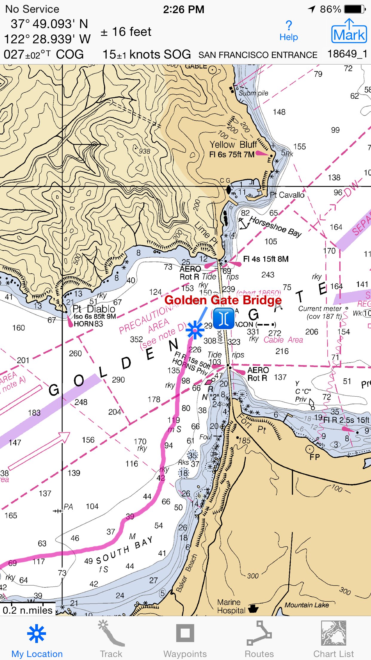
Unleash the navigation potential of your iPhone or iPad with SailGPS! Turn your device into a high-performance GPS receiver with USA NOAA Raster Nautical Charts, even without a cell signal!
Rated “Best Choice — Excellent” by Practical-Sailor.com
Caught in a storm on the water and your chart plotter fails? Don't worry! Download this app now and regain full navigation capabilities to safely return to port. Better yet, buy iSailGPS today ensuring you're prepared for any situation, even in areas with no cell service.
One Low Price! Everything included. No sign-ups, ads, subscriptions or in-app purchases. Completely respects your privacy.
Unrivaled Features to Enhance Your Journey:
TRACKS, WAYPOINTS & ROUTES
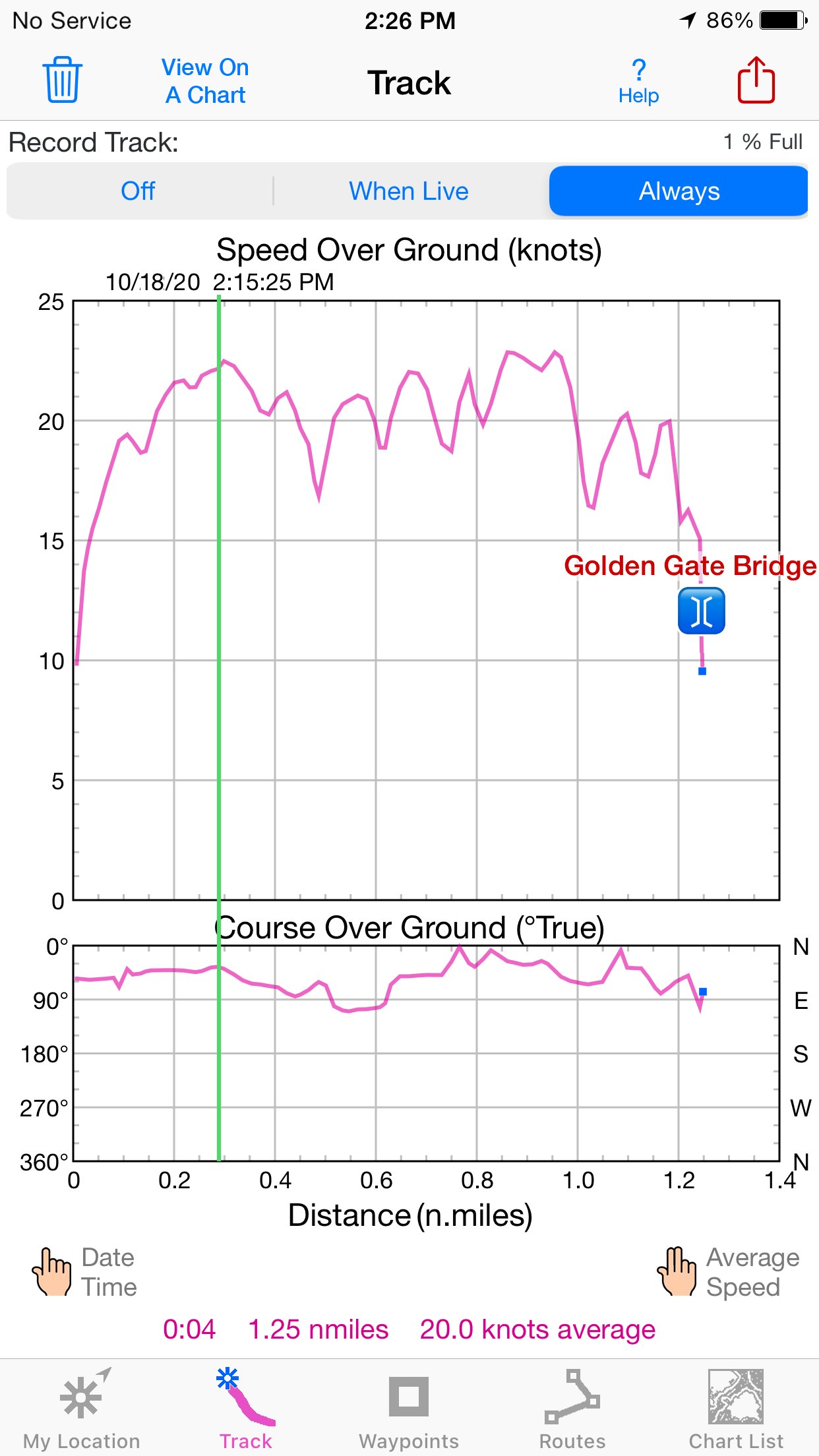
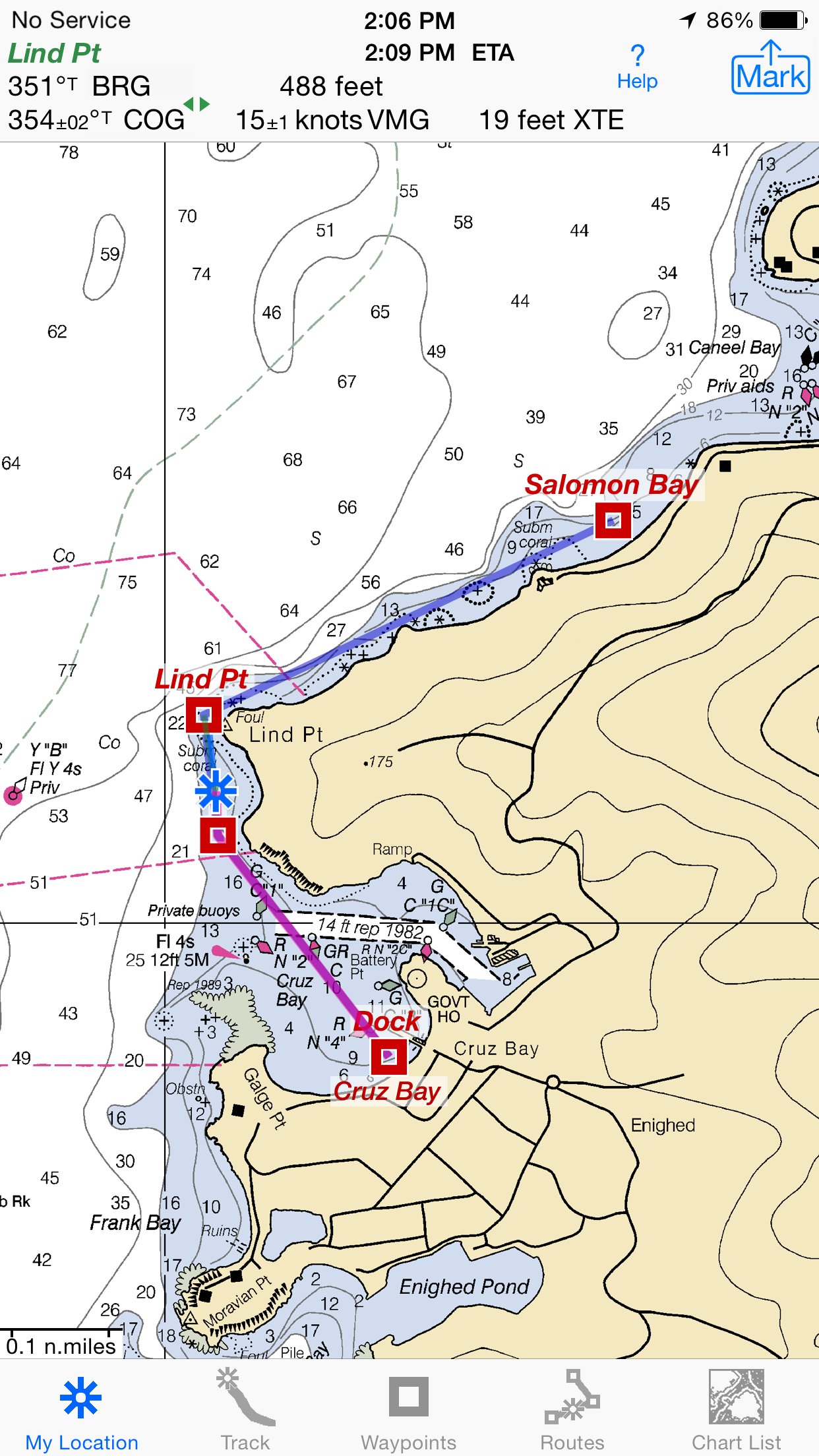
Record tracks as you sail, even in the background. View them on the chart and in a Speed & Course Over Ground graph.
Mark waypoints precisely using charts or satellite maps, place names or addresses, geotagged photos, or by projecting from a known point.
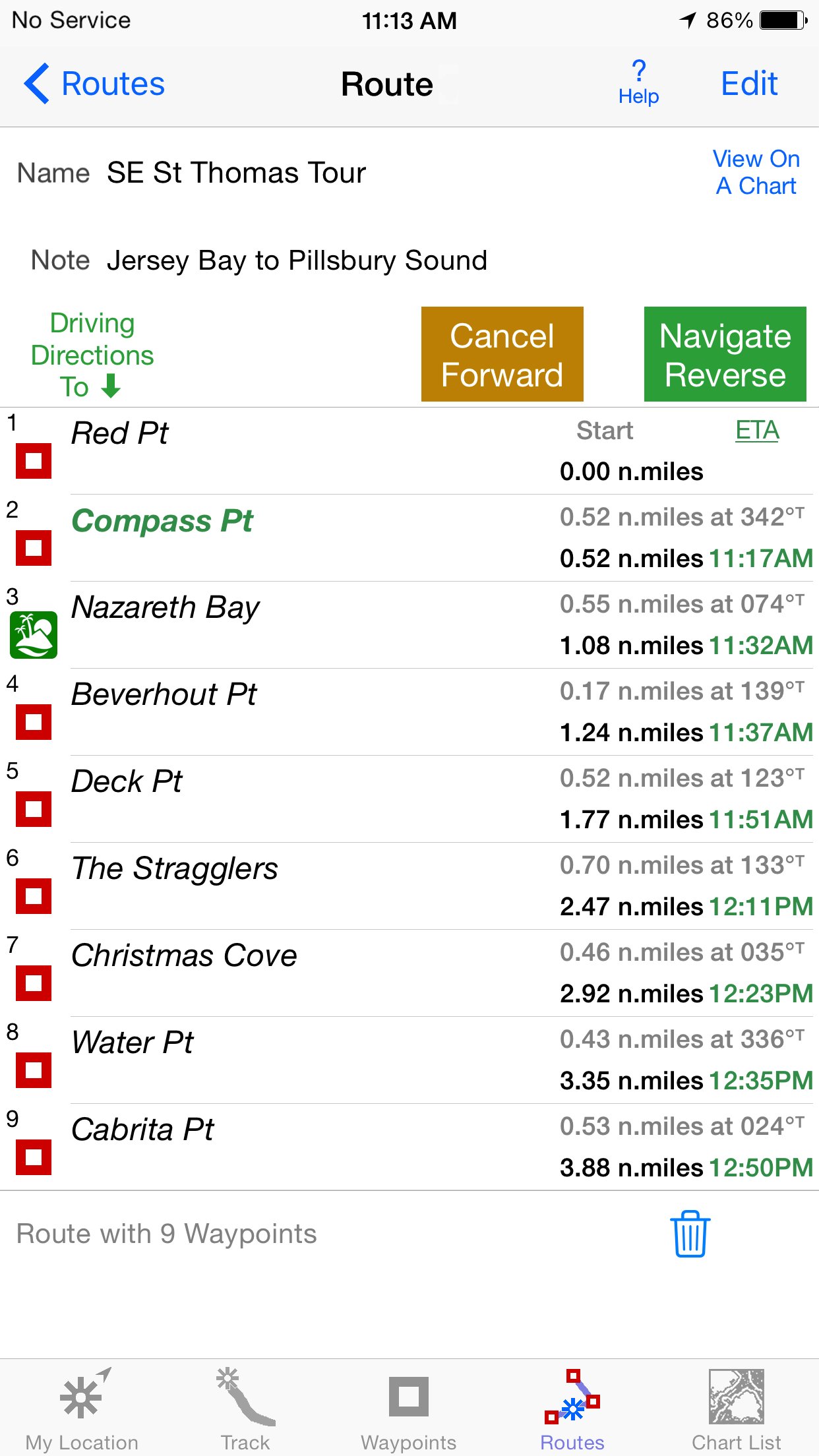
Set a quick GoTo waypoint or a full route and see the course (COG), heading (HDG), bearing (BRG), direction, distance, cross track error (XTE), Velocity Made Good (VMG) and Estimated Time of Arrival (ETA) at your destination and intermediate points. Perfect for racing enthusiasts.
In a Man Overboard (MOB) emergency a single button press marks your current position & starts navigating to it.
Create customized routes using waypoints, recorded tracks, or imported GPX, KML or TCX files. Advanced route editing.
Send GPX and KML waypoint, route, track and map list files via AirDrop, eMail, Messages, or iCloud Drive.
View the sun & moon position and rise & set times for any date & place on earth.
Send data to other apps such as Google Earth.
USA NOAA RASTER NAUTICAL CHARTS
Access to all NOAA RNC Charts for USA waters with no extra charge. Download using WiFi or cell service.
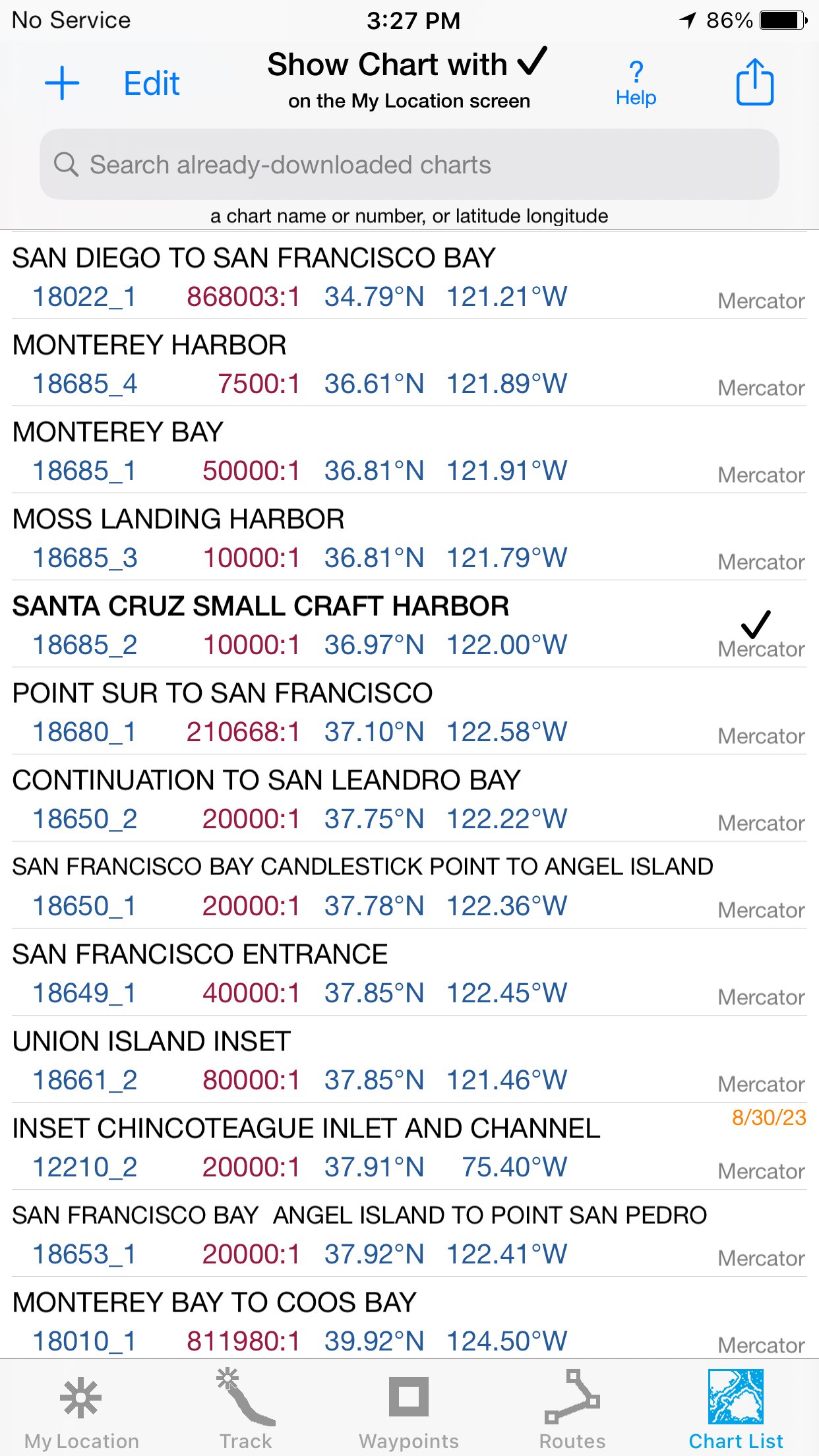
Our chart files are optimized to download faster & use less storage memory. Store up to 2200 charts to use anytime at sea without cell service.
Stitches charts & automatically switches between downloaded charts as you sail. Choose detailed or overview charts.
Print & Share chart images overlaid with waypoints, routes & tracks.
Measure distance & direction between any 2 points.
NOAA charts don't include most inland rivers & small lakes. Use our iHikeGPS app for these.
HOW TOS
Tap Help in the app.
Online Manual: isailgps.com
Email developer: lwjames@isailgps.com
RASTER CHARTS VS. VECTOR CHARTS
The National Oceanic & Atmospheric Administration has provided both RNC (raster) & ENC (vector) charts.
The great advantage of the high resolution RNC charts used by iSailGPS is the high level of detail produced by professional cartographers that is unobtainable on any vector-based chart.
These RNC Charts differ from vector charts in that each chart covers a specific area, just as paper nautical charts do. Switches automatically to a new chart when your boat leaves the area covered by the previous chart. For most locations, there are multiple charts at different scales with different levels of detail & areas of coverage.
Paper charts can have multiple panels, each showing a different area or scale. Each digital panel is individually displayed by iSailGPS with a north-up orientation.
iSail GPS is priced to make it readily available to all boating enthusiasts.
Winner of the Practical Sailor Editors’ Choice Award.
DEVICE REQUIREMENTS
Use iSailGPS on any iOS device even if you don't have a cellular data plan for it. iPhones & WiFi+cellular iPads support full navigation. For WiFi-only iPads & iPod touch, an iOS-compatible external GPS receiver is required to show your location on the water & record tracks. However, you can view charts using the iOS device alone.
Discover a safer and more enjoyable sailing experience with iSailGPS!
License: Commercial
Rated “Best Choice — Excellent” by Practical-Sailor.com
Caught in a storm on the water and your chart plotter fails? Don't worry! Download this app now and regain full navigation capabilities to safely return to port. Better yet, buy iSailGPS today ensuring you're prepared for any situation, even in areas with no cell service.
One Low Price! Everything included. No sign-ups, ads, subscriptions or in-app purchases. Completely respects your privacy.
Unrivaled Features to Enhance Your Journey:
TRACKS, WAYPOINTS & ROUTES
Record tracks as you sail, even in the background. View them on the chart and in a Speed & Course Over Ground graph.
Mark waypoints precisely using charts or satellite maps, place names or addresses, geotagged photos, or by projecting from a known point.
Set a quick GoTo waypoint or a full route and see the course (COG), heading (HDG), bearing (BRG), direction, distance, cross track error (XTE), Velocity Made Good (VMG) and Estimated Time of Arrival (ETA) at your destination and intermediate points. Perfect for racing enthusiasts.
In a Man Overboard (MOB) emergency a single button press marks your current position & starts navigating to it.
Create customized routes using waypoints, recorded tracks, or imported GPX, KML or TCX files. Advanced route editing.
Send GPX and KML waypoint, route, track and map list files via AirDrop, eMail, Messages, or iCloud Drive.
View the sun & moon position and rise & set times for any date & place on earth.
Send data to other apps such as Google Earth.
USA NOAA RASTER NAUTICAL CHARTS
Access to all NOAA RNC Charts for USA waters with no extra charge. Download using WiFi or cell service.
Our chart files are optimized to download faster & use less storage memory. Store up to 2200 charts to use anytime at sea without cell service.
Stitches charts & automatically switches between downloaded charts as you sail. Choose detailed or overview charts.
Print & Share chart images overlaid with waypoints, routes & tracks.
Measure distance & direction between any 2 points.
NOAA charts don't include most inland rivers & small lakes. Use our iHikeGPS app for these.
HOW TOS
Tap Help in the app.
Online Manual: isailgps.com
Email developer: lwjames@isailgps.com
RASTER CHARTS VS. VECTOR CHARTS
The National Oceanic & Atmospheric Administration has provided both RNC (raster) & ENC (vector) charts.
The great advantage of the high resolution RNC charts used by iSailGPS is the high level of detail produced by professional cartographers that is unobtainable on any vector-based chart.
These RNC Charts differ from vector charts in that each chart covers a specific area, just as paper nautical charts do. Switches automatically to a new chart when your boat leaves the area covered by the previous chart. For most locations, there are multiple charts at different scales with different levels of detail & areas of coverage.
Paper charts can have multiple panels, each showing a different area or scale. Each digital panel is individually displayed by iSailGPS with a north-up orientation.
iSail GPS is priced to make it readily available to all boating enthusiasts.
Winner of the Practical Sailor Editors’ Choice Award.
DEVICE REQUIREMENTS
Use iSailGPS on any iOS device even if you don't have a cellular data plan for it. iPhones & WiFi+cellular iPads support full navigation. For WiFi-only iPads & iPod touch, an iOS-compatible external GPS receiver is required to show your location on the water & record tracks. However, you can view charts using the iOS device alone.
Discover a safer and more enjoyable sailing experience with iSailGPS!
License: Commercial
| Release info | New Release on Apr 24, 2026 |
|---|---|
| Release notes | Improved wording on some Alerts and Notifications. What's new in iSailGPS when compared with other available NOAA chart apps? • You don't just see Waypoints and Routes displayed on the chart, you can actually do real great circle navigation to those Waypoints and along those Routes. You get information such as Estimated Time of Arrival, current bearing, heading and cross-track error, and remaining distances to your intermediate and final destinations. • You don't just see individual charts. Whenever the map projection is compatible (which it is most cases), you can see adjacent charts with their margins removed stitched together seamlessly, even when the chart scales are different. For example you can see the approach chart and the corresponding harbor detail chart both together on the same screen. • You can create, import, edit, export, and navigate both on routes based on a recorded or imported path, and on routes based on a series of waypoints. • Get the weather report and forecast, the sun and moon position, rise and set times, and driving directions to the dock for any point on a chart with a few taps. • iSailGPS's code size is kept very small by efficient programming so in an emergency, you can download it easily even over a weak cell connection. • The current version of iSailGPS runs on the latest devices and also on older devices with older versions of iOS , all the way back to devices such as the iPhone 6. • There is never any confusion over what charts you have available offline. They are clearly listed by NOAA chart name and number, and shown on an overview map. • Check the App Privacy section. We don't know who you are when you are using iSailGPS. We never send your current location or your recorded track to our servers. Hence we cannot and don't use your location data. We cannot and don't provide your location data to anyone else. Unlike other mapping apps that profit from using your location data in ways that do not keep it private, iSailGPS m |
| Listing data | App Store |
Reviews
No reviews yet. Be the first to review iSailGPS.
Used iSailGPS? Tell other visitors what you thought.
Log in to write a reviewOther products by this publisher
- "No Distractions" for YouTube 4.10 ----
- #Bible 11.5 "Incredible App - My sister shared this app with me a few weeks ago and it is truly incredible.
- #filmphotography 1.4.2 So, you decided to shoot on film?
- $quirrel 1.5.1 $quirrel Budget & Finance helps you plan each paycheck, track spending, manage debt, and see what is safe to spend before the next payday.
- % Percentage Calculator Pro 1.41 This is the Pro version of % Percentage Calculator.
Most viewed iOS Navigation
-
1
 Compass App 1.0.5
Find your direction with style.
-
2
 CARFACE Car Widgets & Lyrics 1.2.0
Make every drive feel more personal with CarFace.
-
3
 Turo 26.44.1
Turo is a better car rental app for travelers who want to rent a car without the rental counter.
-
4
 iGlide Lite 2.9.66
NaviLogic iGlide - the Soaring Navigation app for iOS
-
5
 Open Road 1.2
Open Road is the one driving app for your iPhone.
-
6
 Amtrak 6.1.8
Discover the convenience of traveling with Amtrak.
-
7
 Kruger Birding by Firefinch 7.2.0
Go birding in South Africa's foremost birding spot: the world renowned Kruger National Park!
-
8
 Lyft 2026.42.3
Get where you’re going with Lyft.
-
9
 Waymo 155
Get there with The World’s Most Experienced Driver™
-
10
 Pocket Luach Deluxe 60058
Pocket Luach Deluxe is a Jewish calendar, zmanim, Siddur, Tehillim, and personal-event companion for iPhone, iPad, and Apple Watch.
Most downloaded iOS Navigation
-
1
 Live Traffic 2.4
Navigate the globe with live traffic updates, satellite views, and location tools that make every journey clearer, smarter, and more confident from the very first tap.
-
2
 Peru’s Best 2.5
PERU’S BEST is the ideal travel guide to this extraordinary country.
-
3
 Grand Egyptian Museum (GEM) 0.1.054
You could call this a coincidence but the acronym of the Grand Egyptian Museum is an apt title for the GEM, which is truly one!
-
4
Pocket Luach Deluxe 60058
Pocket Luach Deluxe is a Jewish calendar, zmanim, Siddur, Tehillim, and personal-event companion for iPhone, iPad, and Apple Watch.
-
5
 Outdoor Photography Magazine 7.2.10
Outdoor Photography is the magazine for photographers who are passionate about being out in wild places, seeing inspiring nature and having great adventures.
-
6
 Great Circle Map 1.7.4
A globe you can turn in any direction, including straight over the poles.
-
7
 Passeporté 1.3.2
Passeporté reads the NFC chip in your biometric passport or national eID card, verifies its authenticity, and stores the data securely on your device.
-
8
 UK Map 4.12
* Unlimited free map downloads based on Ordnance Survey® OpenData, at 1:25,000 and 1:10,000 scales, and now also paid map downloads at 1:50,000, 1:25,000 and 1:10,000 scales, just like the paper maps.
-
9
 Cell Phone Towers World Map 1.1.6
219 countres !! The world's largest Database of Cell & Net Towers
-
10
 Lime 3.288.0
You have places to be and people to see.