GoGIS 1.4.4301
GoGIS brings your GIS data, field records, and spatial analysis together on iPhone and iPad.
Download
64.36 MB
6downloads
4this week
FreeCommercial
0reviews
Screenshots
About GoGIS
GoGIS brings your GIS data, field records, and spatial analysis together on iPhone and iPad.
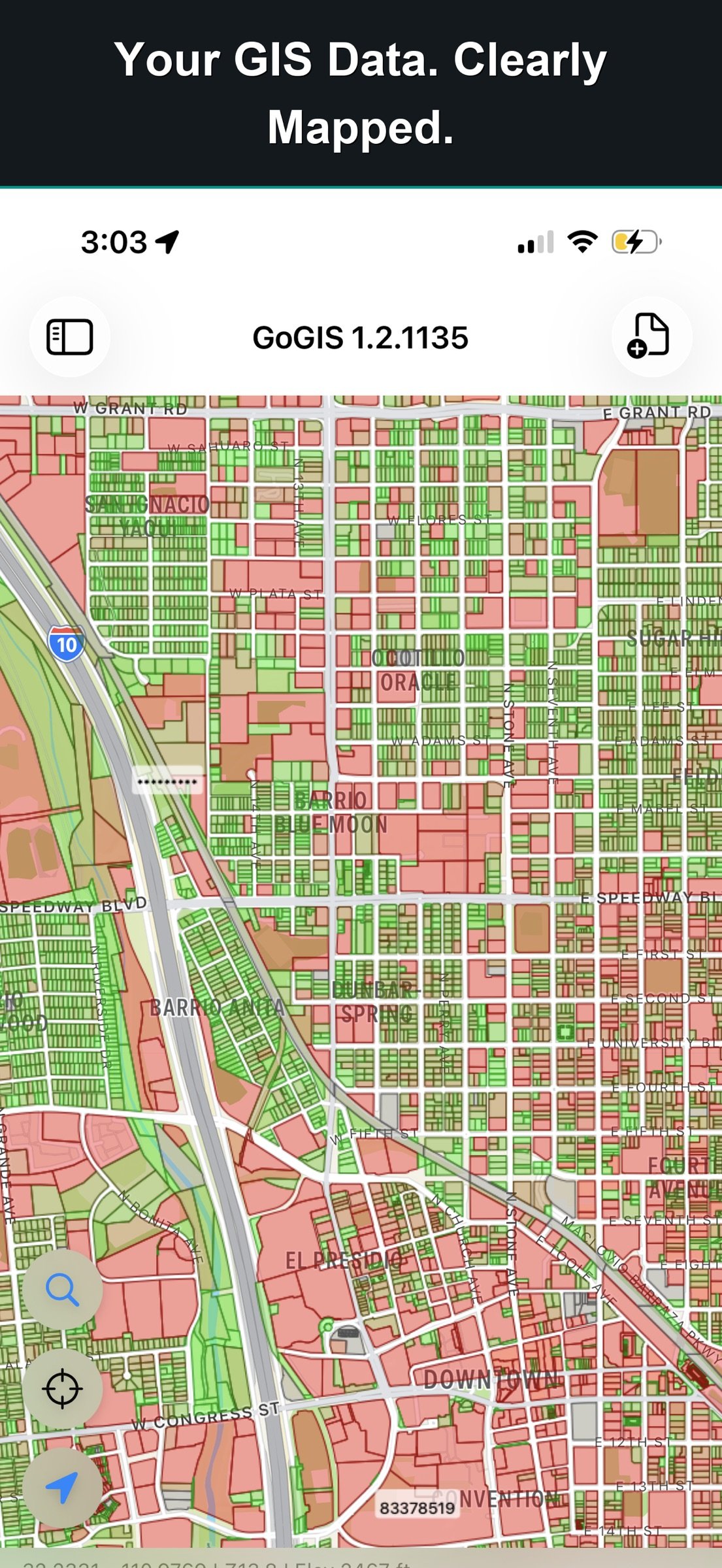
Explore detailed maps, inspect infrastructure, plan sampling work, and analyze features on location. Use your existing GIS files, keep observations connected to the map, and share the results.
DATA FOR YOUR AREA
Download ready-to-use layers from Reference Data: cadastral parcels for Germany, the Netherlands, France, Brazil, Colombia, Australia and New Zealand; crop fields for Germany, the Netherlands, France and Sweden; soil maps for the US, Canada, Australia, Sweden and Córdoba; Japan's farm fields; and OpenStreetMap anywhere in the world.
EXPLORE YOUR DATA
Open Shapefile, GeoJSON, KML, KMZ, GeoPackage, and CSV files. Combine layers, color features by attribute, and add labels to reveal patterns. Work with large parcel and infrastructure datasets, then inspect individual features.
Search, sort, filter, and edit records in the attribute grid. Update individual values or apply changes across selected features.
ANALYZE ON LOCATION
Use Buffer, Intersect, Difference, and Dissolve on layers or selected features. Find parcels within a chosen distance of a site. Subtract mapped wetlands and measure the remaining area. Intersect soil classifications with field boundaries.
CAPTURE FIELD RECORDS
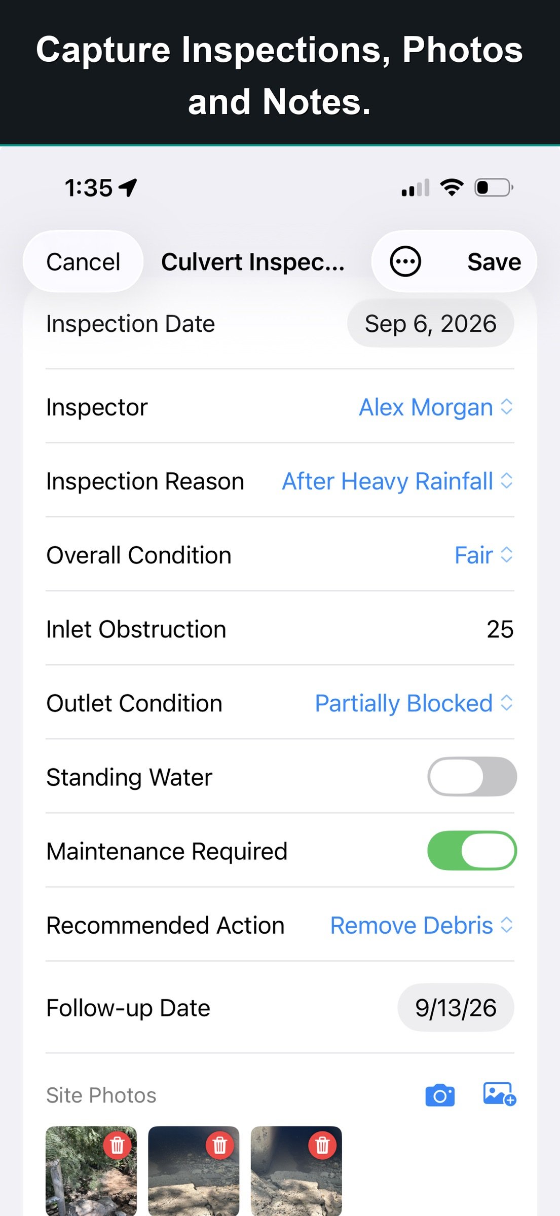
Build custom forms with pick lists, measurements, multiple-choice fields, ratings, and calculated values. Conditional fields show follow-up questions when they apply.
Attach photos, scan barcodes, capture signatures, and make field drawings. Record observations with their GPS location, even without cell coverage.
KEEP EVERY VISIT WITH THE ASSET
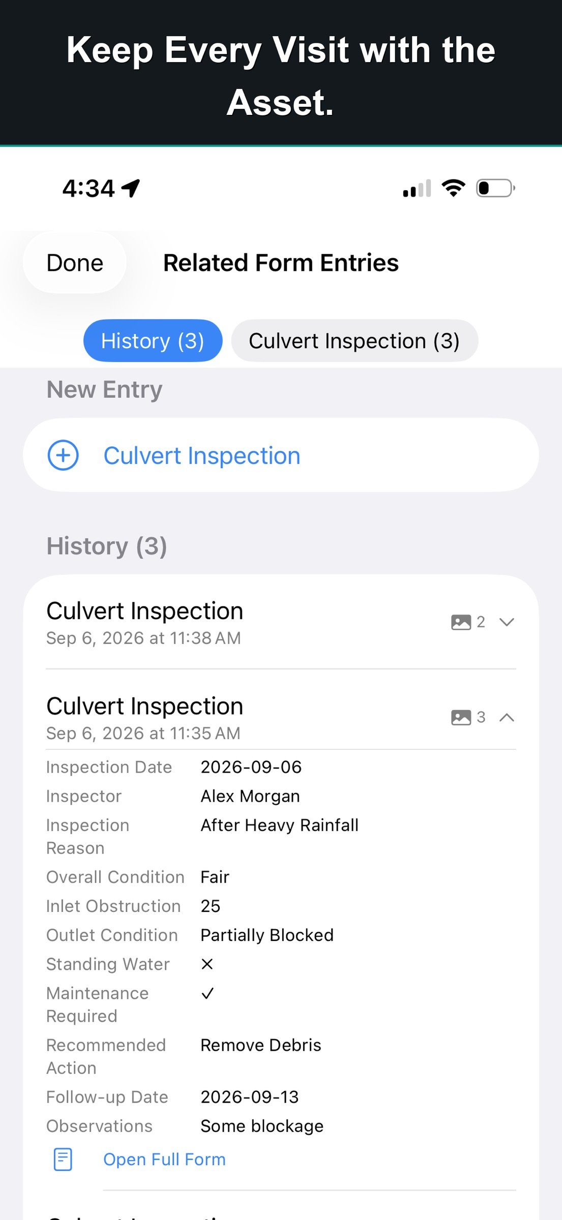
Use related forms to retain separate inspections, readings, or maintenance records against the same feature. Photograph an obstruction, record its condition, and specify an action. Add the next inspection without replacing earlier records. Compare visits in the grid to see what changed.
PLAN SAMPLES AND MAP RESULTS
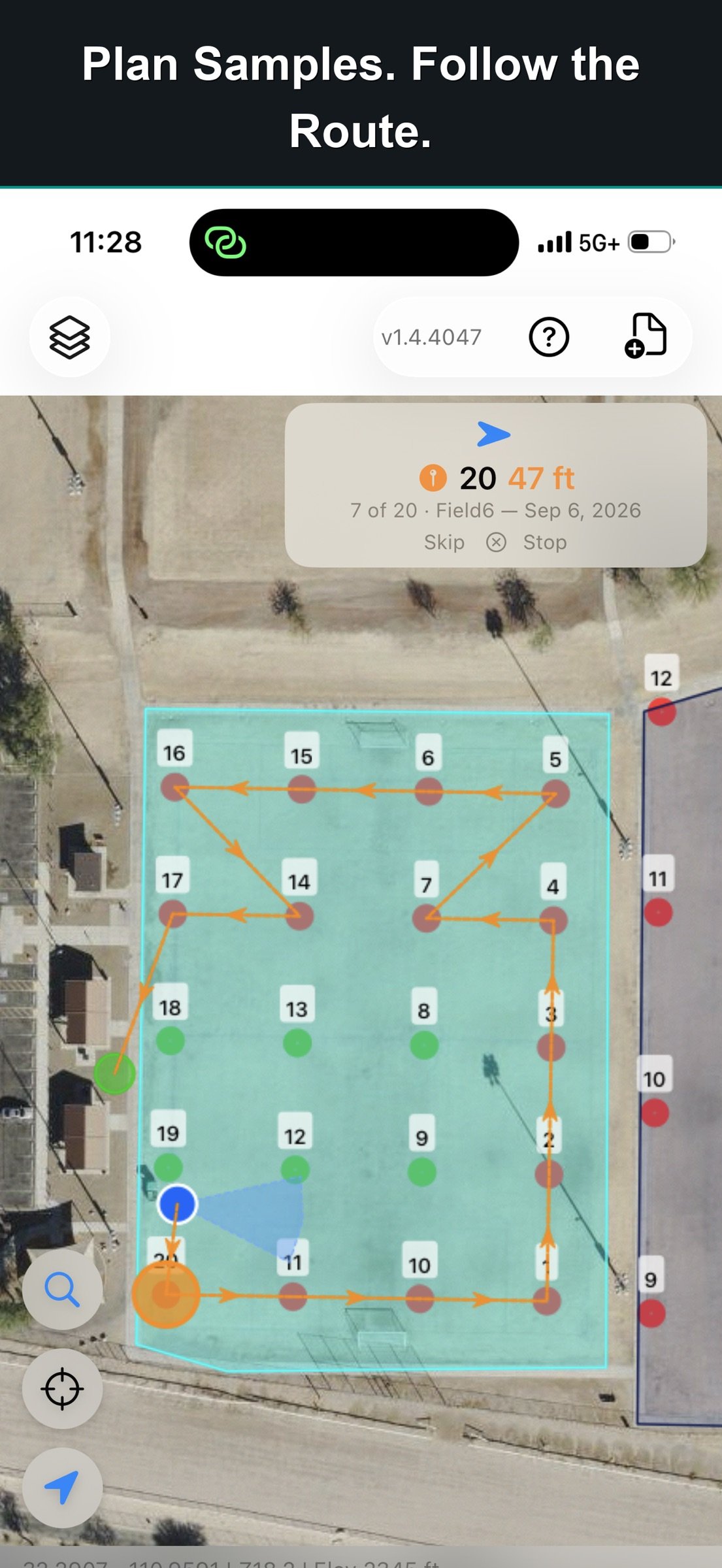
Generate numbered sample grids within a boundary. Adjust spacing, rotation, and offset. Follow a route with direction and distance to the next sample, while tracking completed locations and remaining work.
Print QR or barcode bag labels and record each collection. Import lab results from CSV files, matching the lab’s identifier to your sample field. Keep successive results linked to the same locations.
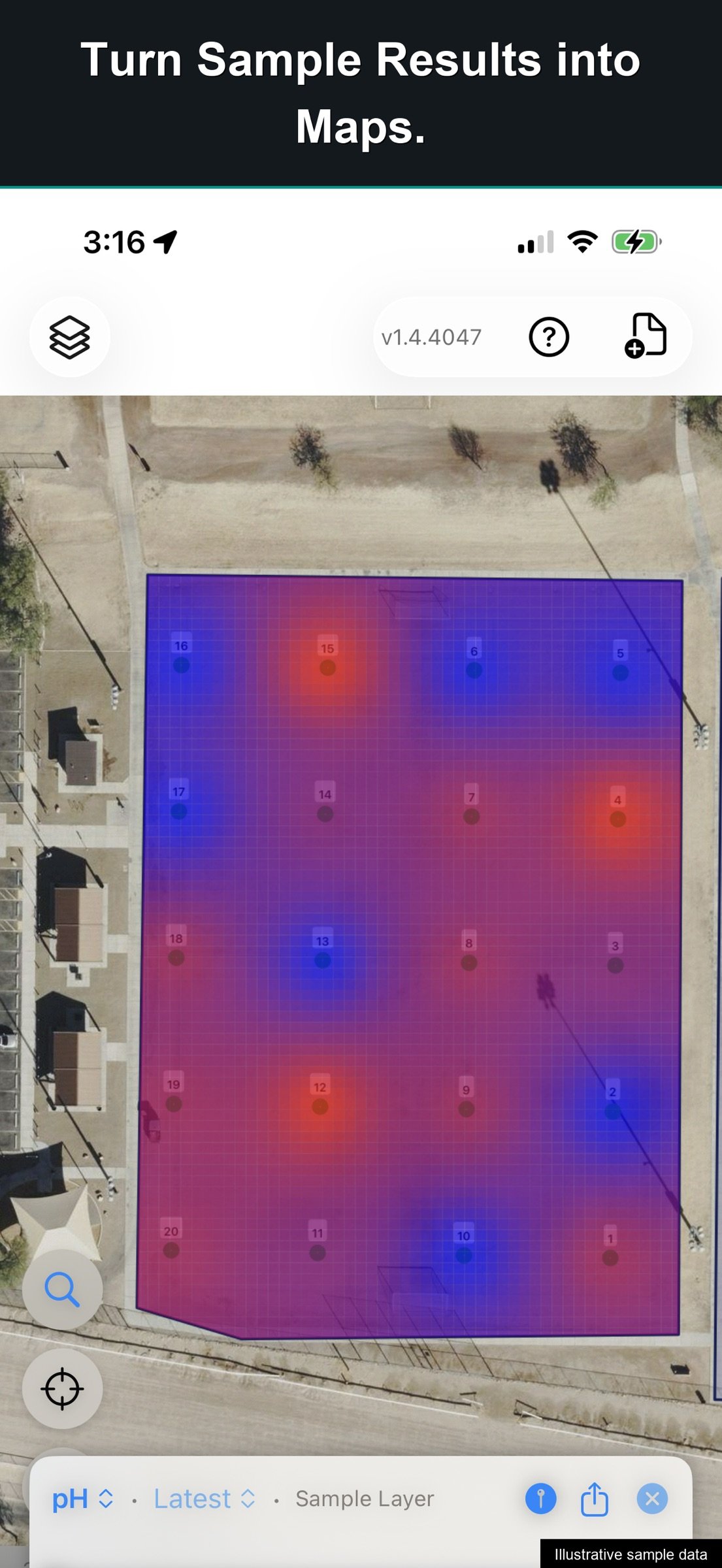
Create interpolated surfaces from values such as pH, nutrients, or elevation. Clip results to field boundaries and compare patterns on a shared color scale.
BRING YOUR IMAGERY
Import GeoTIFF or MBTiles imagery alongside your vector layers. Use satellite, aerial, or drone imagery to give features context. Convert GeoTIFF on the device, adjust opacity, and arrange layers to suit the work.
WORK OFFLINE
Imported vector data and field records stay on your device. View layers, collect observations, and run geometry operations without an internet connection.
COLLECT WITH GPS
See live GPS accuracy while collecting or navigating, and save accuracy with collected points. Draw points, lines, and polygons manually, or use Walk to Draw to add locations as you move. Supported external GPS receivers can also be used.
EXCHANGE WORK BETWEEN DEVICES
Field Sync exchanges project changes between nearby GoGIS devices over a local connection. Transfer feature records, related forms, and photos without a cloud account.
SHARE THE RESULTS
Create PDF maps with a legend, scale bar, and north arrow. Generate sampling reports with overview maps and mapped result pages.
Export layers as GeoJSON, KML, Shapefile, or CSV, and export related records for further work. Choose from more than 90 coordinate systems for Shapefile output.
One-time purchase. No subscription or account required.
License: Commercial
Explore detailed maps, inspect infrastructure, plan sampling work, and analyze features on location. Use your existing GIS files, keep observations connected to the map, and share the results.
DATA FOR YOUR AREA
Download ready-to-use layers from Reference Data: cadastral parcels for Germany, the Netherlands, France, Brazil, Colombia, Australia and New Zealand; crop fields for Germany, the Netherlands, France and Sweden; soil maps for the US, Canada, Australia, Sweden and Córdoba; Japan's farm fields; and OpenStreetMap anywhere in the world.
EXPLORE YOUR DATA
Open Shapefile, GeoJSON, KML, KMZ, GeoPackage, and CSV files. Combine layers, color features by attribute, and add labels to reveal patterns. Work with large parcel and infrastructure datasets, then inspect individual features.
Search, sort, filter, and edit records in the attribute grid. Update individual values or apply changes across selected features.
ANALYZE ON LOCATION
Use Buffer, Intersect, Difference, and Dissolve on layers or selected features. Find parcels within a chosen distance of a site. Subtract mapped wetlands and measure the remaining area. Intersect soil classifications with field boundaries.
CAPTURE FIELD RECORDS
Build custom forms with pick lists, measurements, multiple-choice fields, ratings, and calculated values. Conditional fields show follow-up questions when they apply.
Attach photos, scan barcodes, capture signatures, and make field drawings. Record observations with their GPS location, even without cell coverage.
KEEP EVERY VISIT WITH THE ASSET
Use related forms to retain separate inspections, readings, or maintenance records against the same feature. Photograph an obstruction, record its condition, and specify an action. Add the next inspection without replacing earlier records. Compare visits in the grid to see what changed.
PLAN SAMPLES AND MAP RESULTS
Generate numbered sample grids within a boundary. Adjust spacing, rotation, and offset. Follow a route with direction and distance to the next sample, while tracking completed locations and remaining work.
Print QR or barcode bag labels and record each collection. Import lab results from CSV files, matching the lab’s identifier to your sample field. Keep successive results linked to the same locations.
Create interpolated surfaces from values such as pH, nutrients, or elevation. Clip results to field boundaries and compare patterns on a shared color scale.
BRING YOUR IMAGERY
Import GeoTIFF or MBTiles imagery alongside your vector layers. Use satellite, aerial, or drone imagery to give features context. Convert GeoTIFF on the device, adjust opacity, and arrange layers to suit the work.
WORK OFFLINE
Imported vector data and field records stay on your device. View layers, collect observations, and run geometry operations without an internet connection.
COLLECT WITH GPS
See live GPS accuracy while collecting or navigating, and save accuracy with collected points. Draw points, lines, and polygons manually, or use Walk to Draw to add locations as you move. Supported external GPS receivers can also be used.
EXCHANGE WORK BETWEEN DEVICES
Field Sync exchanges project changes between nearby GoGIS devices over a local connection. Transfer feature records, related forms, and photos without a cloud account.
SHARE THE RESULTS
Create PDF maps with a legend, scale bar, and north arrow. Generate sampling reports with overview maps and mapped result pages.
Export layers as GeoJSON, KML, Shapefile, or CSV, and export related records for further work. Choose from more than 90 coordinate systems for Shapefile output.
One-time purchase. No subscription or account required.
License: Commercial
| Release info | Update on Nov 10, 2026 |
|---|---|
| Release notes | Coordinates in your country's grid Tap the coordinates at the bottom of the map: Lambert 93 in France, OS grid references in Britain, UTM in Germany, SWEREF 99 in Sweden and more. Choose what the strip shows, and type those coordinates into search. Italy's cadastral parcels Every parcel with its comune, foglio and particella, over the satellite map. South Tyrol comes from the Province of Bolzano; Trentino isn't covered yet. Crown land and protected areas in Canada Ontario's Crown land and land-use policy areas, British Columbia's land ownership and Canada's protected areas, colored by who owns or manages them. Zoning in France PLU zones and carte communale sectors (urban, to be developed, agricultural, natural) with a link to the commune's rules. A zone isn't a building permit. Japan's registry map (??) Lot numbers town by town from the Ministry of Justice. Lots its map can't place are counted by district, and Find Lot finds any lot number from a deed. |
| Listing data | App Store |
Reviews
No reviews yet. Be the first to review GoGIS.
Used GoGIS? Tell other visitors what you thought.
Log in to write a reviewOther products by this publisher
- "No Distractions" for YouTube 4.10 ----
- #Bible 11.6 "Incredible App - My sister shared this app with me a few weeks ago and it is truly incredible.
- #filmphotography 1.4.2 So, you decided to shoot on film?
- $quirrel 1.5.1 $quirrel Budget & Finance helps you plan each paycheck, track spending, manage debt, and see what is safe to spend before the next payday.
- % Percentage Calculator Pro 1.41 This is the Pro version of % Percentage Calculator.
Most viewed iOS Business
-
1
 Navy Federal Credit Union 2026.10.2
Bank easy with the Navy Federal mobile app!
-
2
 Paycom 8.0.14
If you or your company use Paycom’s HR and software, the Paycom app helps you manage everyday HR and payroll tasks in one place — like checking your schedule, requesting time off and reviewing your pay.
-
3
 Entrust Identity 26.3.0
The Entrust Identity mobile application is the new Entrust mobile platform for delivering strong identity credentials to both employee and consumer users.
- 4 % Percentage Calculator Pro 1.41 This is the Pro version of % Percentage Calculator.
-
5
 Intune Company Portal 5.2610.0
Microsoft Intune helps organizations manage access to corporate apps, data, and resources.
-
6
 ParkNYC Powered by Flowbird 2.2
Have you ever been late to an important meeting and you can’t find a parking spot?
-
7
 Budget-Beacon 1.5
Budget Beacon connects to your Apple Wallet to help you understand and manage your spending.
-
8
 Shopify 11.2645.0
Shopify: build your online store, sell anywhere, run your business
-
9
 MiniVAN Touch 9.4.6
miniVAN Touch is a mobile canvassing application that integrates with websites provided by NGP VAN.
-
10
 Muha Members 2.0.3
With Muha Members, you’re now equipped to verify authenticity like a pro and protect yourself from counterfeits.
Most downloaded iOS Business
-
1
ParkNYC Powered by Flowbird 2.2
Have you ever been late to an important meeting and you can’t find a parking spot?
-
2
Budget-Beacon 1.5
Budget Beacon connects to your Apple Wallet to help you understand and manage your spending.
-
3
 Rocket.Chat 4.78.1
Rocket.Chat Secure CommsOS™ is a communication platform that unifies messaging, voice, video, AI, and mission-critical applications—ensuring uncompromising security, compliance, and operational efficiency for governments, defense, and critical infra…
-
4
 Business Timesheet 6.0
Are you looking for timesheet to track the work hours spent on hourly, daily or weekly basis accurately?
-
5
 Cvent Events 2.8.1
Cvent Events is your place to easily plan out your event experience, find where you need to go next, network with other attendees, and learn more about sponsors and exhibitors.
-
6
 Receivable Payment Ledger2026 1.1
Payment Ledger is a fully offline accounts receivable management tool for small businesses, shops, wholesalers, and salespeople who need to track customer debts and payment progress.
-
7
 Simple Budget Envelopes 2.2.1
An incredibly simple app, perfect for keeping track of how much money remains in your budget.
- 8 $quirrel 1.5.1 $quirrel Budget & Finance helps you plan each paycheck, track spending, manage debt, and see what is safe to spend before the next payday.
-
9
 Vola 4.9.01
Vola is the only cash advance app built for Real-Time Payments (RTP).
- 10 % Percentage Calculator Pro 1.41 This is the Pro version of % Percentage Calculator.