
Footpath Route Planner 5.1.1
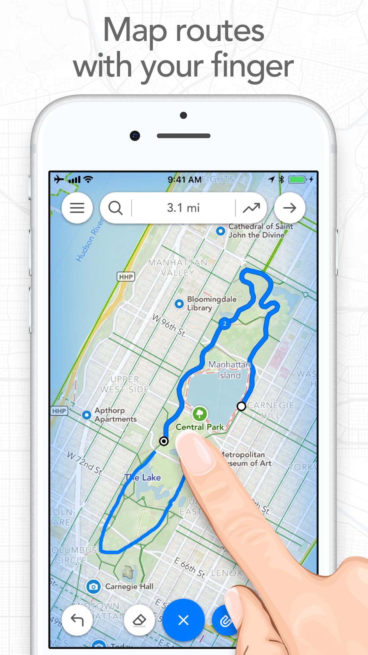
Map routes with your finger and Footpath will snap to roads and trails.
Download
155.29 MB
7downloads
2this week
FreeFreeware
0reviews
Screenshots
About Footpath Route Planner
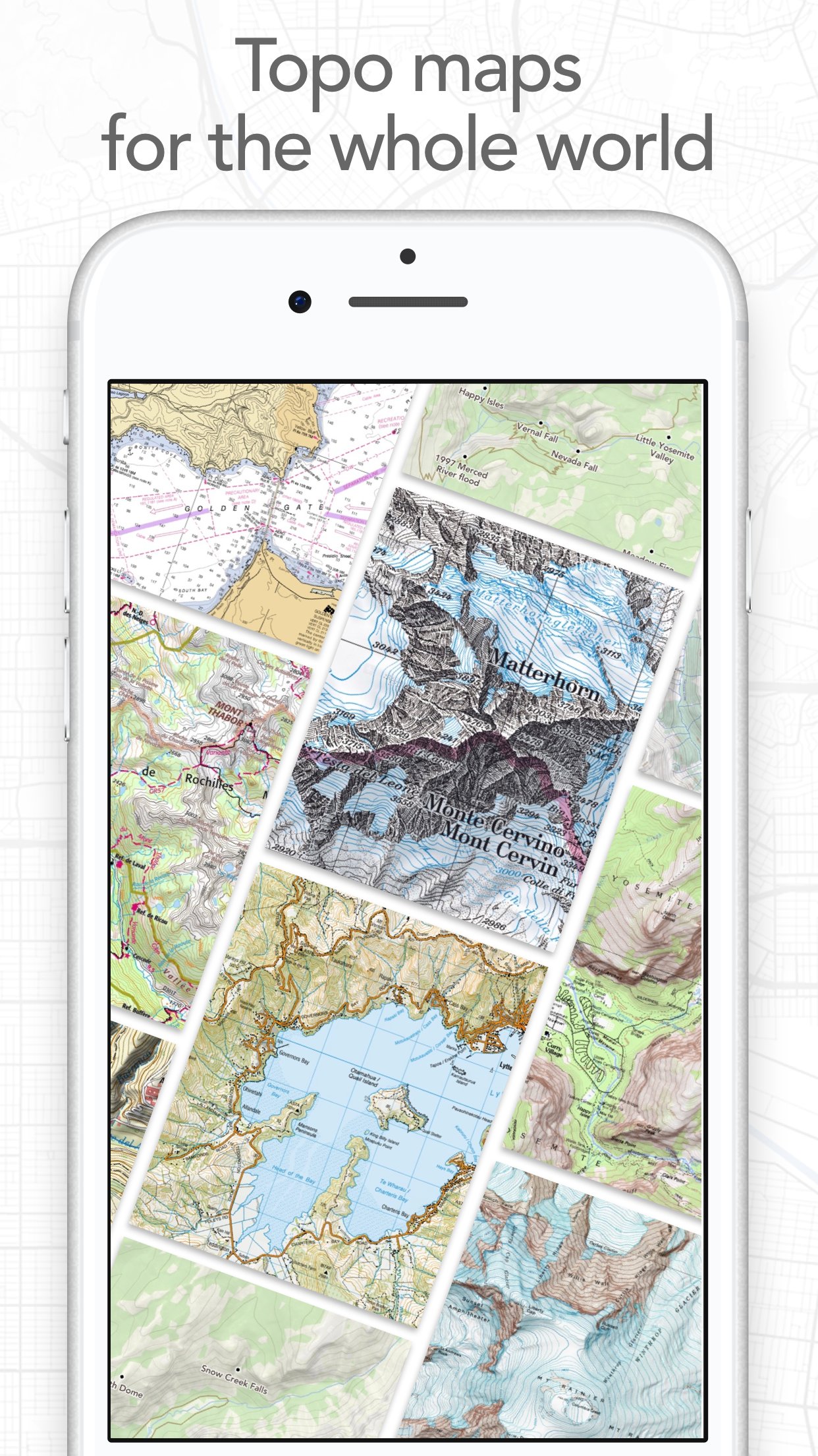
Map routes with your finger and Footpath will snap to roads and trails. Measure distances and elevations in seconds, then navigate along with turn-by-turn directions.
Footpath is the ultimate companion for planning and navigating custom routes.
Join millions of adventurers and plan out your perfect route.
SNAP TO MAP
Quickly measure distances by tracing a map with your finger or Apple Pencil. Footpath will snap to roads and trails on the map.
MEASURE DISTANCE AND ELEVATION
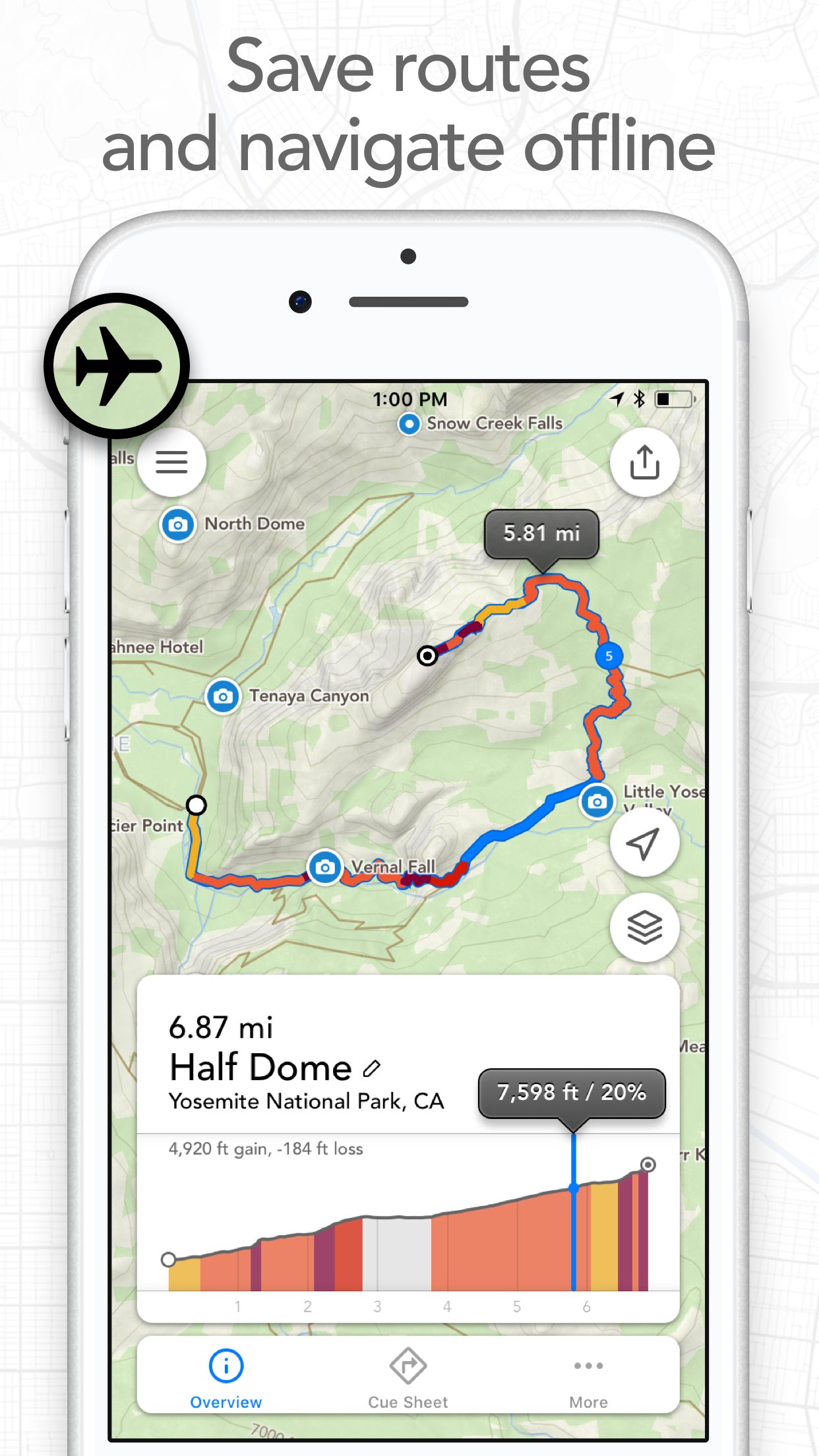
Know exactly how far and how high you'll travel with elevation profiles. Plan routes that match your goals.
SAVE ROUTES FOR LATER
Plan out your week or trip. Keep up to 5 routes on hand for reference, or save unlimited routes with Footpath Elite.
SHARE ROUTES
Send your routes to friends or workout partners to open on their device.
Footpath is designed to work for pretty much any activity or adventure, in any country:
• Running
• Cycling and mountain biking
• Hiking and mountaineering
• Walking
• Motorcycling and driving
• Backcountry skiing
• Kayaking and standup paddleboarding
• Sailing
• And many more!
FOOTPATH ELITE
Ready to go the extra mile? Upgrading to Footpath Elite unlocks the following powerful features:
TURN-BY-TURN NAVIGATION
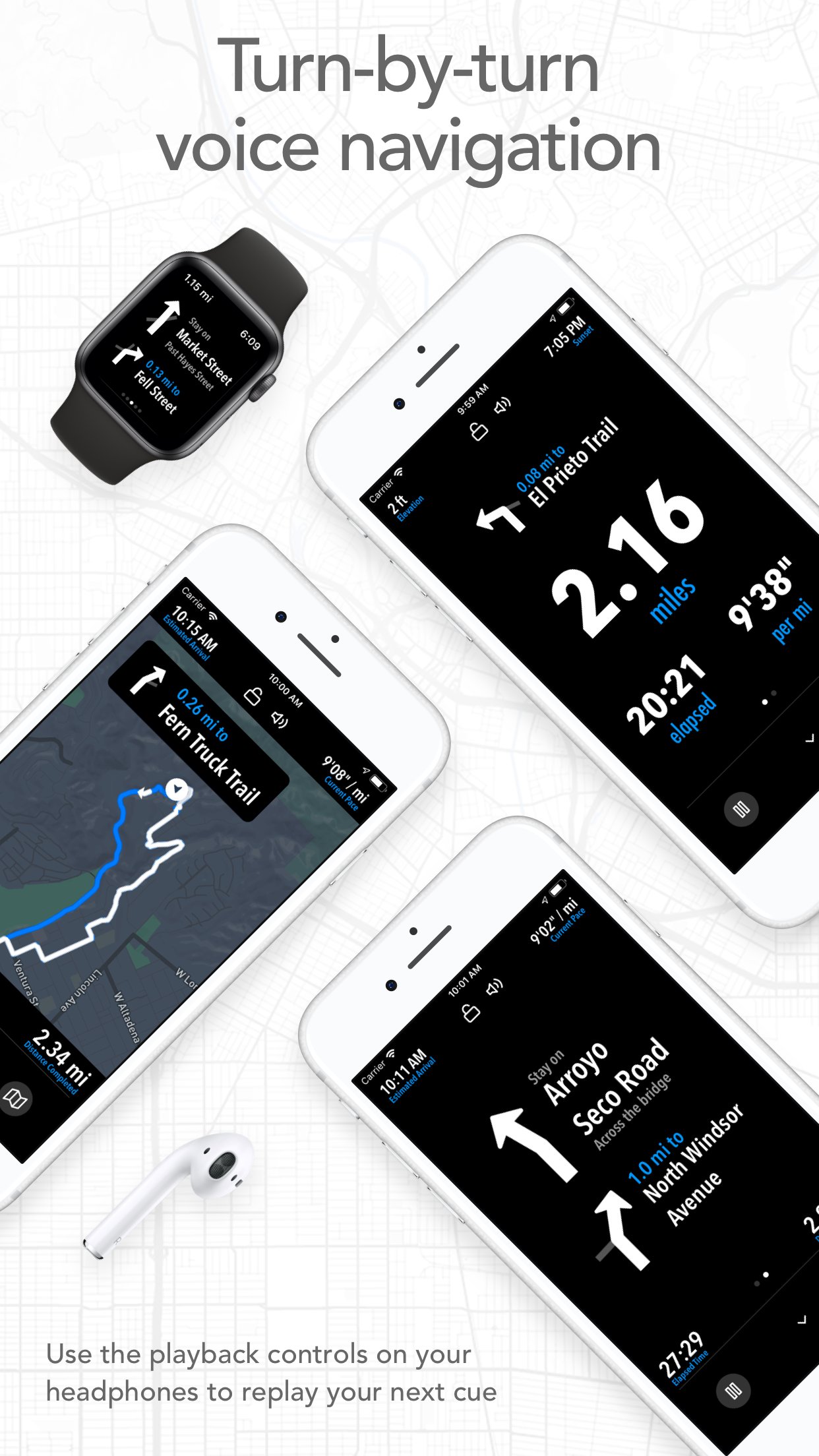
- Footpath will tell you when to turn with turn-by-turn audio cues on your iPhone and Apple Watch
- Save your route and cues in advance for voice guidance that works completely offline
- Double tap your AirPods or use the playback controls button on your headphones to replay your next cue
PREMIUM OFFLINE MAPS
- 3D and topographic maps including Footpath Outdoors (Worldwide), USGS Topo Maps (U.S. and Canada), OpenCycleMap (Worldwide), and many more
- Cycling lanes, avalanche slope shading, and elevation contour lines
- Download maps for use offline
- Save places as favorites to customize your maps
ORGANIZE
- Create and edit unlimited saved routes
- Duplicate, merge, and split routes
- Organize and sort routes into custom lists
ANALYZE
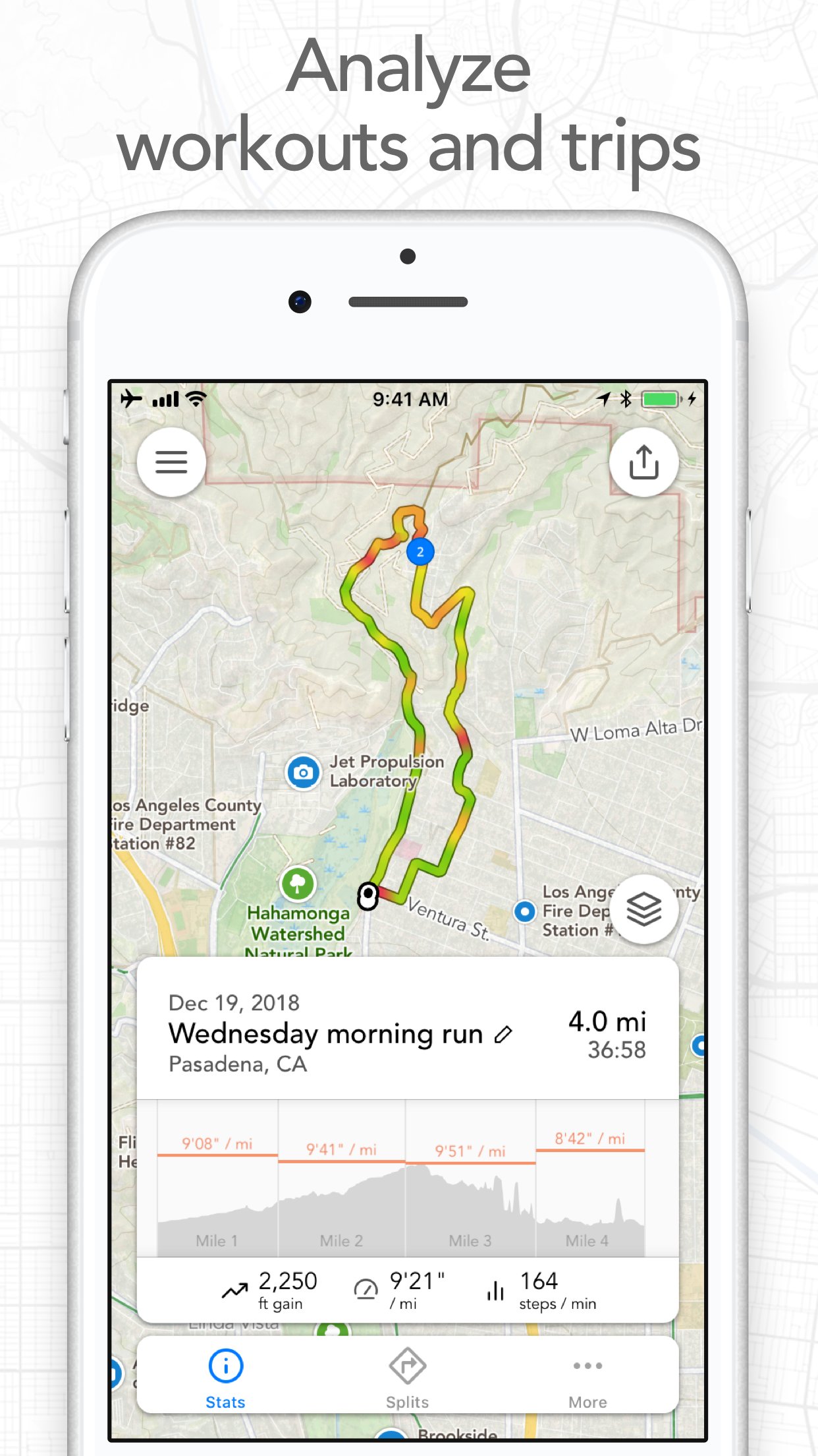
- Record GPS tracks of your activities
- Use HealthKit display and log extra health and fitness metrics such as heart rate during a GPS activity
- View a calendar log and weekly summary of your activities
- Analyze splits, speed, elevation, and heart rate
- View a heatmap of your speed during your activity
EXPORT
- GPX import and export
- TCX and FIT course export for turn-by-turn navigation on Garmin and Wahoo GPS devices
- Export cue sheets to a spreadsheet app for customization and printing
- Export your routes and workouts to Apple Health
You can purchase a Footpath Elite monthly or yearly subscription through your iTunes account. Your subscription will automatically renew unless cancelled at least 24 hours before the end of the current period. Auto-renew can be turned off anytime by going to the Manage Subscriptions page in settings after purchase, and your features will remain active until the end of the subscription period. Your account will be charged for renewal within 24-hours prior to the end of the current period at the same cost as your original purchase.
TIPS FOR MAPPING ROUTES
• For longer routes, try zooming in and mapping your route in multiple segments.
• Tap and hold the map to quickly route between waypoints and POIs.
• Did Footpath snap to the wrong roads? Trace over the incorrect segment to edit, or use the eraser tool.
• Turn off snap to roads (magnet icon) and zoom in to manually trace the map. (Try switching to a satellite layer).
• Displaying maps and continuously running GPS in the background can dramatically decrease battery life. Navigate without maps or with the screen off for all day battery life.
CONTACT US
We've got a lot planned for Footpath. If you have any suggestions or feedback, or if you run into any issues, please contact us at support@footpathapp.com
Terms of Service: [link removed]
Privacy Policy: [link removed]
License: Free
Footpath is the ultimate companion for planning and navigating custom routes.
Join millions of adventurers and plan out your perfect route.
SNAP TO MAP
Quickly measure distances by tracing a map with your finger or Apple Pencil. Footpath will snap to roads and trails on the map.
MEASURE DISTANCE AND ELEVATION
Know exactly how far and how high you'll travel with elevation profiles. Plan routes that match your goals.
SAVE ROUTES FOR LATER
Plan out your week or trip. Keep up to 5 routes on hand for reference, or save unlimited routes with Footpath Elite.
SHARE ROUTES
Send your routes to friends or workout partners to open on their device.
Footpath is designed to work for pretty much any activity or adventure, in any country:
• Running
• Cycling and mountain biking
• Hiking and mountaineering
• Walking
• Motorcycling and driving
• Backcountry skiing
• Kayaking and standup paddleboarding
• Sailing
• And many more!
FOOTPATH ELITE
Ready to go the extra mile? Upgrading to Footpath Elite unlocks the following powerful features:
TURN-BY-TURN NAVIGATION
- Footpath will tell you when to turn with turn-by-turn audio cues on your iPhone and Apple Watch
- Save your route and cues in advance for voice guidance that works completely offline
- Double tap your AirPods or use the playback controls button on your headphones to replay your next cue
PREMIUM OFFLINE MAPS
- 3D and topographic maps including Footpath Outdoors (Worldwide), USGS Topo Maps (U.S. and Canada), OpenCycleMap (Worldwide), and many more
- Cycling lanes, avalanche slope shading, and elevation contour lines
- Download maps for use offline
- Save places as favorites to customize your maps
ORGANIZE
- Create and edit unlimited saved routes
- Duplicate, merge, and split routes
- Organize and sort routes into custom lists
ANALYZE
- Record GPS tracks of your activities
- Use HealthKit display and log extra health and fitness metrics such as heart rate during a GPS activity
- View a calendar log and weekly summary of your activities
- Analyze splits, speed, elevation, and heart rate
- View a heatmap of your speed during your activity
EXPORT
- GPX import and export
- TCX and FIT course export for turn-by-turn navigation on Garmin and Wahoo GPS devices
- Export cue sheets to a spreadsheet app for customization and printing
- Export your routes and workouts to Apple Health
You can purchase a Footpath Elite monthly or yearly subscription through your iTunes account. Your subscription will automatically renew unless cancelled at least 24 hours before the end of the current period. Auto-renew can be turned off anytime by going to the Manage Subscriptions page in settings after purchase, and your features will remain active until the end of the subscription period. Your account will be charged for renewal within 24-hours prior to the end of the current period at the same cost as your original purchase.
TIPS FOR MAPPING ROUTES
• For longer routes, try zooming in and mapping your route in multiple segments.
• Tap and hold the map to quickly route between waypoints and POIs.
• Did Footpath snap to the wrong roads? Trace over the incorrect segment to edit, or use the eraser tool.
• Turn off snap to roads (magnet icon) and zoom in to manually trace the map. (Try switching to a satellite layer).
• Displaying maps and continuously running GPS in the background can dramatically decrease battery life. Navigate without maps or with the screen off for all day battery life.
CONTACT US
We've got a lot planned for Footpath. If you have any suggestions or feedback, or if you run into any issues, please contact us at support@footpathapp.com
Terms of Service: [link removed]
Privacy Policy: [link removed]
License: Free
| Release info | Update on Oct 27, 2026 |
|---|---|
| Release notes | NEW WAYS TO SHARE - Overlay animated routes over your photos - Create transparent route stickers to overlay over Instagram Stories - Share animated map videos of your route - Friends can scan a QR code to open your route right on their phone 3D FLYOVER PREVIEWS (ELITE) You can now preview your route or replay a recorded activity with cinematic 3D flyover videos OTHER IMPROVEMENTS - Full support for the new iPhone Duo - You can now fine tune your estimated duration and set a start time for predicted ETAs (ELITE) - Fixes issue where Garmin Connect wouldn't save a GPX export from Footpath - Bug fixes Leave us an App Store review if you're enjoying Footpath, or feel free to contact us at support@footpathapp.com with any problems or suggestions. |
| Listing data | App Store |
Reviews
No reviews yet. Be the first to review Footpath Route Planner.
Used Footpath Route Planner? Tell other visitors what you thought.
Log in to write a reviewOther products by this publisher
- "No Distractions" for YouTube 4.10 ----
- #Bible 11.6 "Incredible App - My sister shared this app with me a few weeks ago and it is truly incredible.
- #filmphotography 1.4.2 So, you decided to shoot on film?
- $quirrel 1.5.1 $quirrel Budget & Finance helps you plan each paycheck, track spending, manage debt, and see what is safe to spend before the next payday.
- % Percentage Calculator Pro 1.41 This is the Pro version of % Percentage Calculator.
Most viewed iOS Navigation
-
1
 Compass App 1.0.5
Find your direction with style.
-
2
 CARFACE Car Widgets & Lyrics 1.2.0
Make every drive feel more personal with CarFace.
-
3
 iGlide Lite 2.9.66
NaviLogic iGlide - the Soaring Navigation app for iOS
-
4
 Open Road 1.2
Open Road is the one driving app for your iPhone.
-
5
 Turo 26.45.0
Turo is a better car rental app for travelers who want to rent a car without the rental counter.
-
6
 Kruger Birding by Firefinch 7.6.0
Go birding in South Africa's foremost birding spot: the world renowned Kruger National Park!
-
7
 Amtrak 6.1.8
Discover the convenience of traveling with Amtrak.
-
8
 Fly Delta 7.17.3
Welcome to Fly Delta, Delta’s award winning iOS app.
-
9
 Uber 3.747.10000
Join the millions of riders who trust Uber for their everyday travel needs.
-
10
 Lyft 2026.43.3
Get where you’re going with Lyft.
Most downloaded iOS Navigation
-
1
 Live Traffic 2.4
Navigate the globe with live traffic updates, satellite views, and location tools that make every journey clearer, smarter, and more confident from the very first tap.
-
2
 Peru’s Best 2.5
PERU’S BEST is the ideal travel guide to this extraordinary country.
-
3
 Grand Egyptian Museum (GEM) 0.1.060
You could call this a coincidence but the acronym of the Grand Egyptian Museum is an apt title for the GEM, which is truly one!
-
4
 Pocket Luach Deluxe 60058
Pocket Luach Deluxe is a Jewish calendar, zmanim, Siddur, Tehillim, and personal-event companion for iPhone, iPad, and Apple Watch.
-
5
 Outdoor Photography Magazine 7.2.10
Outdoor Photography is the magazine for photographers who are passionate about being out in wild places, seeing inspiring nature and having great adventures.
-
6
 Passeporté 1.3.2
Passeporté reads the NFC chip in your biometric passport or national eID card, verifies its authenticity, and stores the data securely on your device.
-
7
 Great Circle Map 1.7.5
A globe you can turn in any direction, including straight over the poles.
-
8
 UK Map 4.12
* Unlimited free map downloads based on Ordnance Survey® OpenData, at 1:25,000 and 1:10,000 scales, and now also paid map downloads at 1:50,000, 1:25,000 and 1:10,000 scales, just like the paper maps.
-
9
 Cell Phone Towers World Map 1.1.6
219 countres !! The world's largest Database of Cell & Net Towers
-
10
 Connecticut-Parks & Trails 1.0
App Feature