
FloodRoute 2.5.1
FloodRoute shows which coastal roads will flood at high tide, and when, and lets neighbors post what they're seeing.
Download
54.67 MB
0downloads
0this week
FreeFreeware
0reviews
Screenshots
About FloodRoute
FloodRoute shows which coastal roads will flood at high tide, and when, and lets neighbors post what they're seeing.
As featured in The Ark (Tiburon, CA), January 27, 2026.
WHAT IT DOES
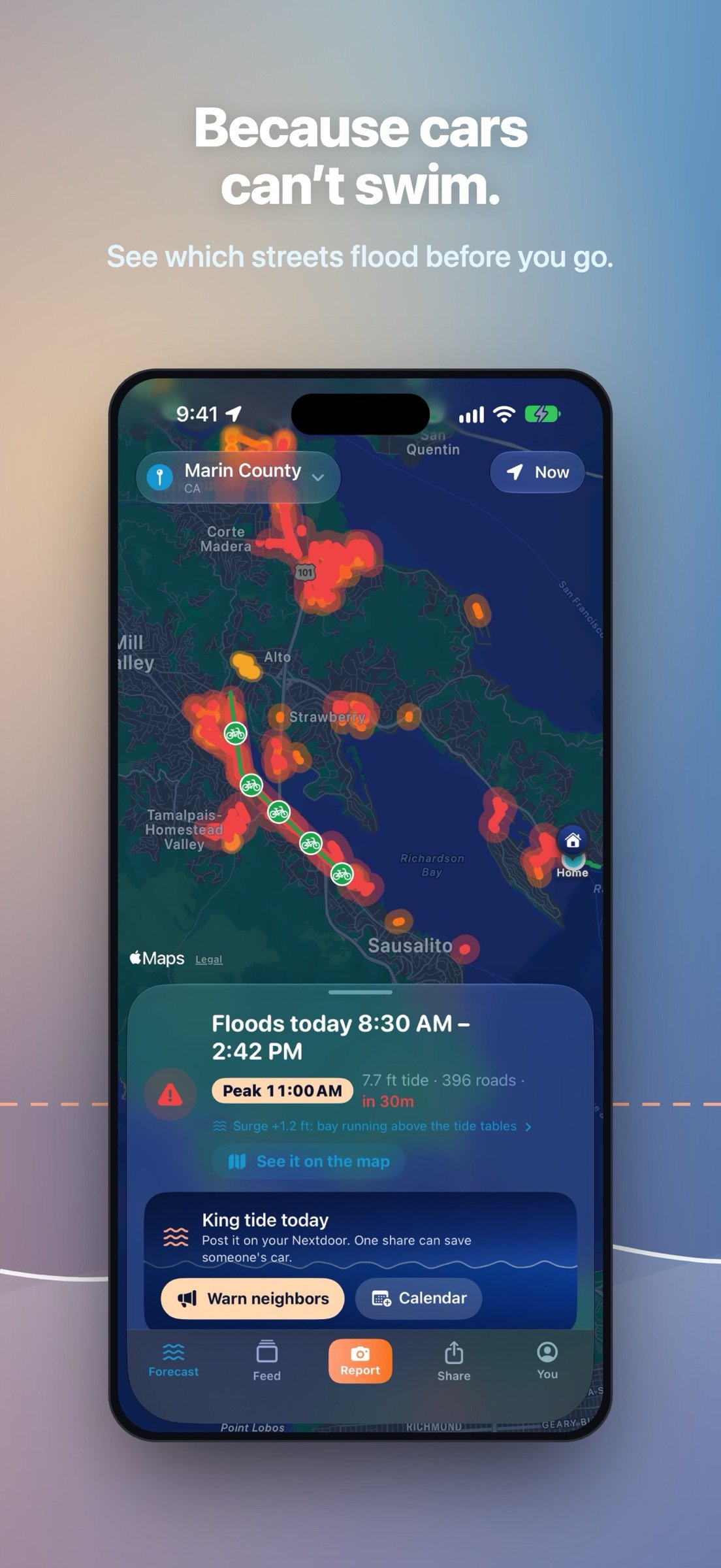
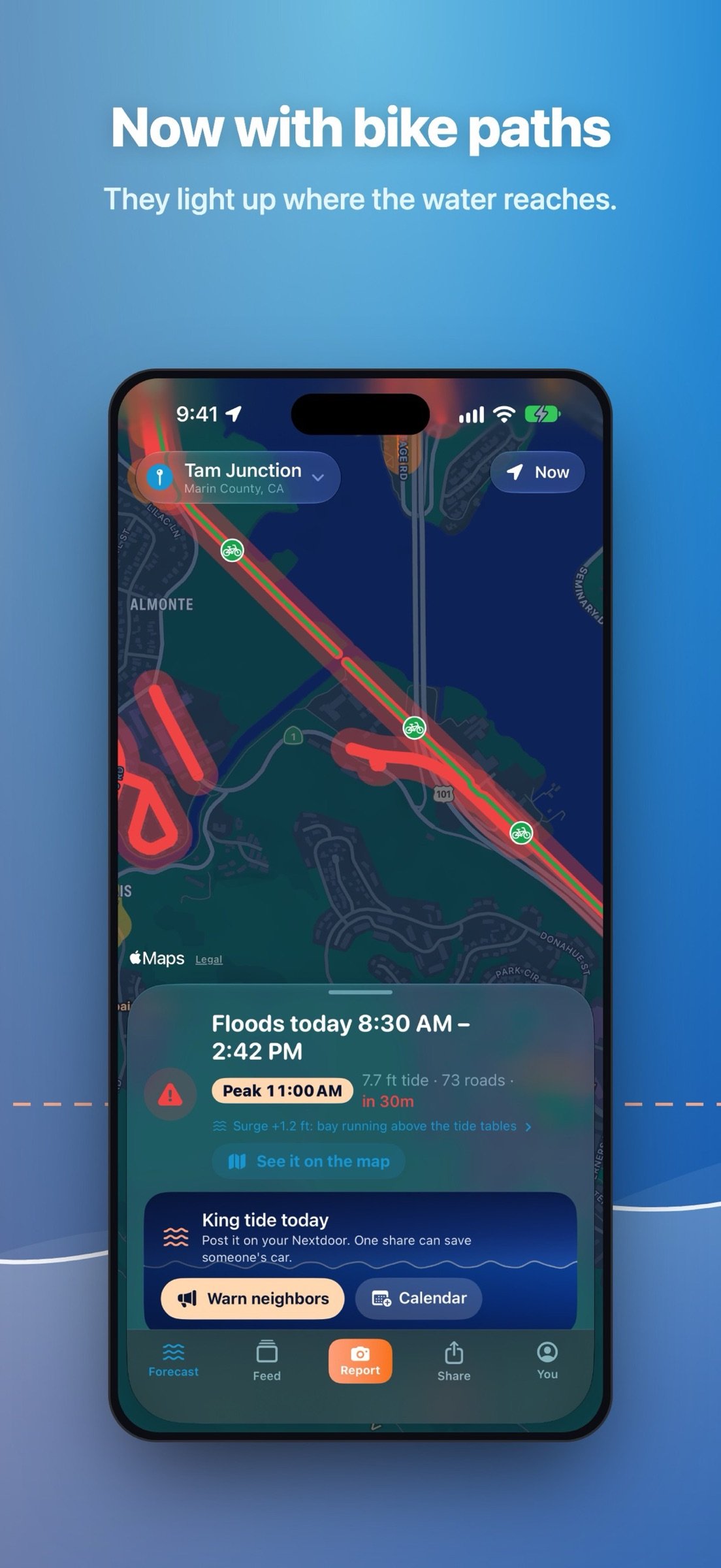
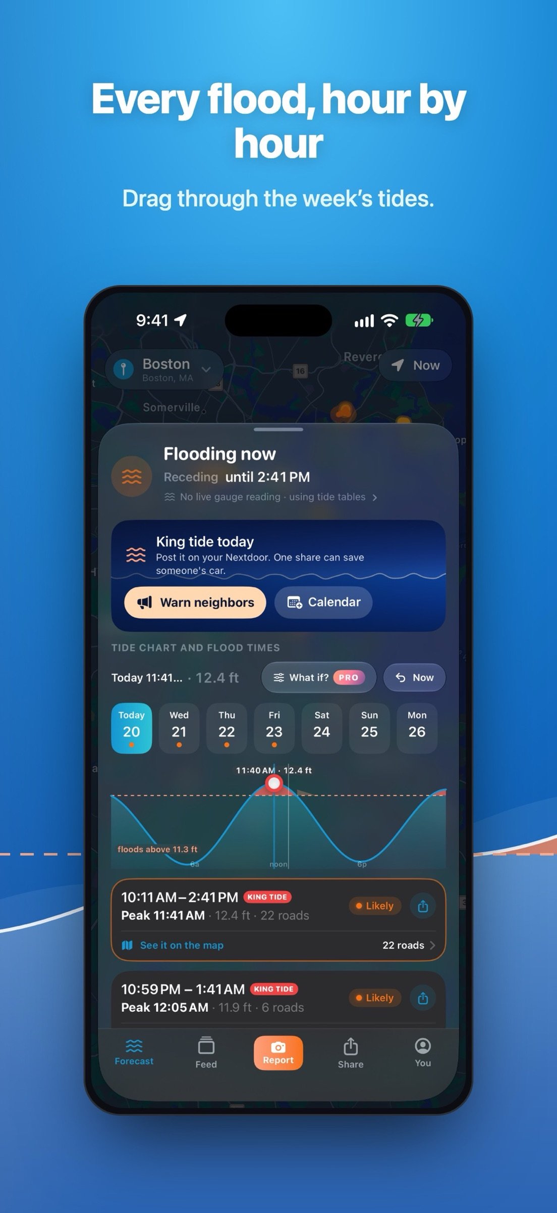
• Street-by-street forecasts: see which roads and bike paths flood at each high tide, and when the water peaks and drains, 7 days ahead.
• Live water levels: forecasts follow the real water, catching surges the tide tables miss. Over the past year, forecasts made a day ahead typically landed within 2 inches of NOAA's gauge; the tide tables alone, 6. Every call is public at floodroute.com/accuracy.
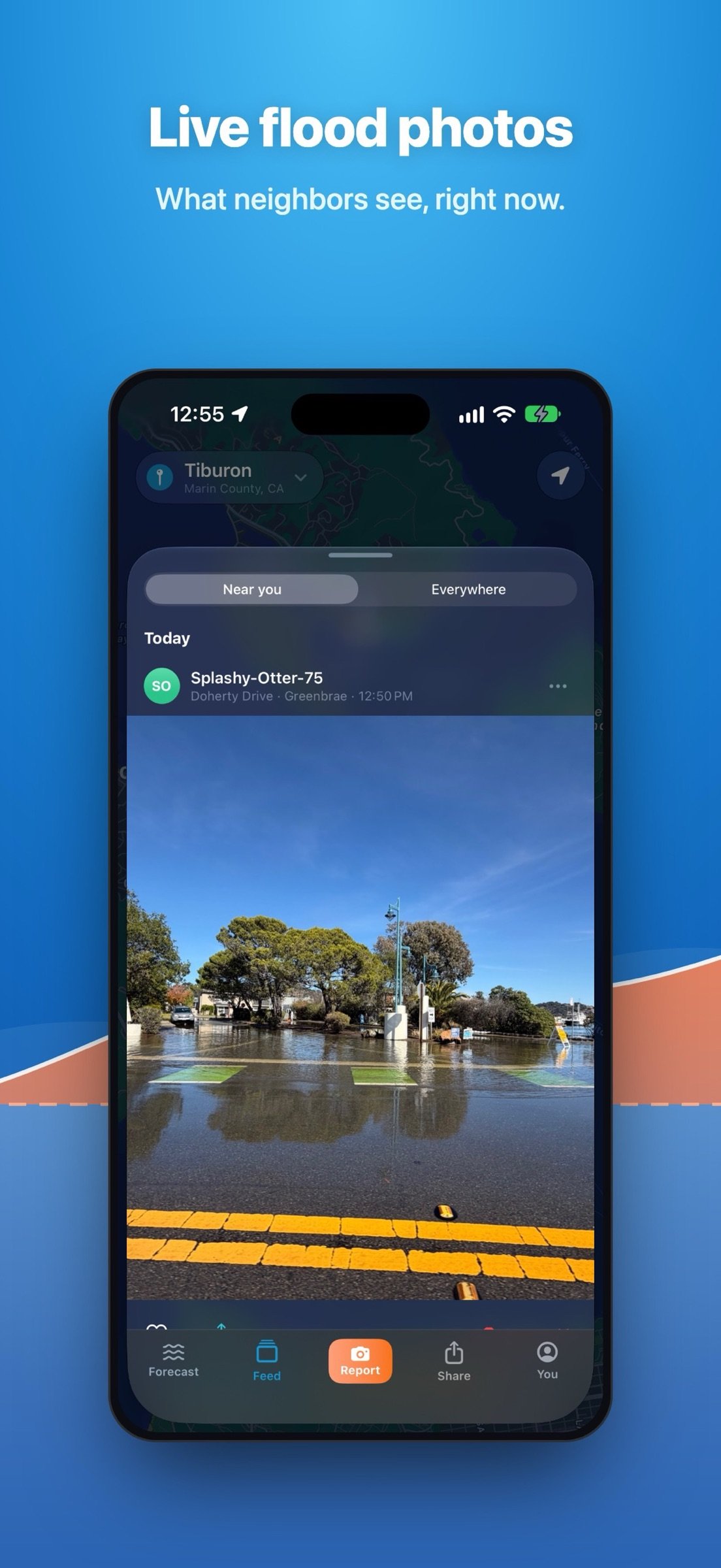
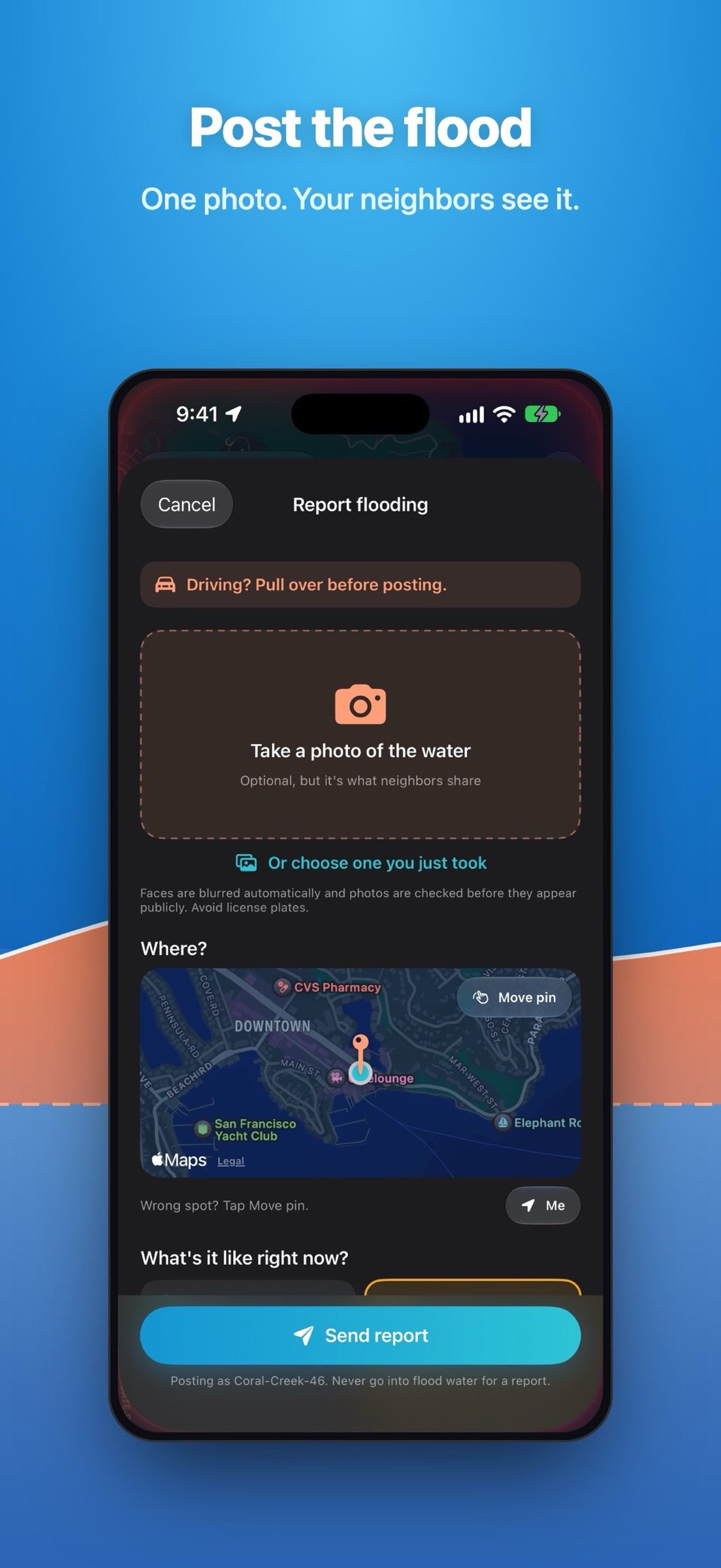
• Flood photos from neighbors: see what's flooding right now. Tap any photo for the street, the time, who spotted it and the map.
• Post in seconds: snap the water and FloodRoute adds the street, the time and the tide height. Faces are blurred automatically. At high tide, one tap tells neighbors "Flooded" or "Looks dry."
• Warn your neighbors: share a forecast or a photo to Nextdoor, Instagram or a group text in one tap. Links open a live map in any browser, no app needed.
• Alerts: a heads-up before your town floods, a ping when a neighbor posts flooding in your town, and a check-in at the peak.
• A map that learns: neighbor reports correct the forecast, so streets seen dry stop showing as flooded.
• Call it: guess how high the next big tide will get. NOAA's gauge decides who was closest, and the best callers top a 30-day leaderboard.
FREE FOR EVERYONE
• The live flood map and 7-day flood windows
• Town alerts and neighbor flood pings
• Posting and sharing flood photos
• No account or login
FLOODROUTE PRO
• Alerts for your street: the roads around your home, hours ahead
• Commute alerts: we check your actual route and tell you when to leave
• Surge alerts: when the water runs high, before the tide tables catch on
• Up to 3 places: home, work and one more
• 30-day flood planner
• What-if simulator: see any tide or storm before it happens
• A PRO badge on your posts
New users get every Pro feature through their town's next big tide. After that, everything free stays free, and Pro is monthly or yearly.
WHERE IT WORKS
• Marin County, CA: 11 towns, from Sausalito to Novato
• San Francisco, CA
• Boston, MA
• New York City, NY
• Miami and Miami Beach, FL
• Tampa, FL
• In beta: much of South Florida, St. Petersburg, Charleston, Norfolk, Virginia Beach and more
HOW IT WORKS
FloodRoute combines NOAA tide predictions and live water levels with high-resolution USGS lidar elevations for every low-lying road. Predictions are calibrated against documented king tides and neighbor reports, and factor in recent rainfall. Every town also has 30 years of flood history at floodroute.com.
DATA SOURCES
• NOAA CO-OPS: tide predictions and live water levels
• USGS 3D Elevation Program: road elevations
• OpenStreetMap and Overture Maps: road geometry
• FEMA National Flood Hazard Layer: flood zones
• Open-Meteo: rainfall and barometric pressure
• Neighbor reports and documented king tide flooding: calibration
WHY I BUILT IT
FloodRoute started with my Nextdoor neighbors in Marin County. I shared the idea and got nearly 200 requests in 24 hours. It's still built by one person, and Pro keeps the free map free.
IMPORTANT SAFETY NOTICE
FloodRoute provides estimates only and is not a substitute for official warnings. Conditions change quickly. Never drive or walk through flood water: turn around, don't drown.
SUBSCRIPTION DETAILS
Payment is charged to your Apple ID at confirmation of purchase. Subscriptions renew automatically unless canceled at least 24 hours before the end of the current period. Manage or cancel anytime in your App Store account settings.
Support: marc@floodroute.com
Follow @floodrouteapp on X: [link removed]
Follow @floodroute on Threads: [link removed]
Terms of Service: [link removed]
Privacy Policy: [link removed]
As featured in The Ark (Tiburon, CA), January 27, 2026.
WHAT IT DOES
• Street-by-street forecasts: see which roads and bike paths flood at each high tide, and when the water peaks and drains, 7 days ahead.
• Live water levels: forecasts follow the real water, catching surges the tide tables miss. Over the past year, forecasts made a day ahead typically landed within 2 inches of NOAA's gauge; the tide tables alone, 6. Every call is public at floodroute.com/accuracy.
• Flood photos from neighbors: see what's flooding right now. Tap any photo for the street, the time, who spotted it and the map.
• Post in seconds: snap the water and FloodRoute adds the street, the time and the tide height. Faces are blurred automatically. At high tide, one tap tells neighbors "Flooded" or "Looks dry."
• Warn your neighbors: share a forecast or a photo to Nextdoor, Instagram or a group text in one tap. Links open a live map in any browser, no app needed.
• Alerts: a heads-up before your town floods, a ping when a neighbor posts flooding in your town, and a check-in at the peak.
• A map that learns: neighbor reports correct the forecast, so streets seen dry stop showing as flooded.
• Call it: guess how high the next big tide will get. NOAA's gauge decides who was closest, and the best callers top a 30-day leaderboard.
FREE FOR EVERYONE
• The live flood map and 7-day flood windows
• Town alerts and neighbor flood pings
• Posting and sharing flood photos
• No account or login
FLOODROUTE PRO
• Alerts for your street: the roads around your home, hours ahead
• Commute alerts: we check your actual route and tell you when to leave
• Surge alerts: when the water runs high, before the tide tables catch on
• Up to 3 places: home, work and one more
• 30-day flood planner
• What-if simulator: see any tide or storm before it happens
• A PRO badge on your posts
New users get every Pro feature through their town's next big tide. After that, everything free stays free, and Pro is monthly or yearly.
WHERE IT WORKS
• Marin County, CA: 11 towns, from Sausalito to Novato
• San Francisco, CA
• Boston, MA
• New York City, NY
• Miami and Miami Beach, FL
• Tampa, FL
• In beta: much of South Florida, St. Petersburg, Charleston, Norfolk, Virginia Beach and more
HOW IT WORKS
FloodRoute combines NOAA tide predictions and live water levels with high-resolution USGS lidar elevations for every low-lying road. Predictions are calibrated against documented king tides and neighbor reports, and factor in recent rainfall. Every town also has 30 years of flood history at floodroute.com.
DATA SOURCES
• NOAA CO-OPS: tide predictions and live water levels
• USGS 3D Elevation Program: road elevations
• OpenStreetMap and Overture Maps: road geometry
• FEMA National Flood Hazard Layer: flood zones
• Open-Meteo: rainfall and barometric pressure
• Neighbor reports and documented king tide flooding: calibration
WHY I BUILT IT
FloodRoute started with my Nextdoor neighbors in Marin County. I shared the idea and got nearly 200 requests in 24 hours. It's still built by one person, and Pro keeps the free map free.
IMPORTANT SAFETY NOTICE
FloodRoute provides estimates only and is not a substitute for official warnings. Conditions change quickly. Never drive or walk through flood water: turn around, don't drown.
SUBSCRIPTION DETAILS
Payment is charged to your Apple ID at confirmation of purchase. Subscriptions renew automatically unless canceled at least 24 hours before the end of the current period. Manage or cancel anytime in your App Store account settings.
Support: marc@floodroute.com
Follow @floodrouteapp on X: [link removed]
Follow @floodroute on Threads: [link removed]
Terms of Service: [link removed]
Privacy Policy: [link removed]
| Release info | New Release on Nov 08, 2026 |
|---|---|
| Release notes | • Bike paths are on the map: green lines with bike signs that light up where the water reaches them. First up in Marin: the Mill Valley–Sausalito path, the Corte Madera Creek path and San Rafael's shoreline. • See a whole county at once: tap Marin County in the town list (its arrow still lists the towns). • "How accurate is FloodRoute?" on the You tab: how far a forecast made a day ahead typically misses the real high tide. Over the past year, about 2 inches; the tide tables alone, about 6. • Pan the map into another area and tap "Show" to switch to it. • Call it results now show how far off FloodRoute was, too. • Asking for a town that's already mapped? Map my town now opens it. • Fixed: the "your town is live" alert could arrive twice. |
| Listing data | App Store |
Reviews
No reviews yet. Be the first to review FloodRoute.
Used FloodRoute? Tell other visitors what you thought.
Log in to write a reviewOther products by this publisher
- "No Distractions" for YouTube 4.10 ----
- #Bible 11.6 "Incredible App - My sister shared this app with me a few weeks ago and it is truly incredible.
- #filmphotography 1.4.2 So, you decided to shoot on film?
- $quirrel 1.5.1 $quirrel Budget & Finance helps you plan each paycheck, track spending, manage debt, and see what is safe to spend before the next payday.
- % Percentage Calculator Pro 1.41 This is the Pro version of % Percentage Calculator.
Most viewed iOS Weather
-
1
 MesoRadar 1.6.0
MesoRadar is a Level 2 NEXRAD radar app for storm spotters, chasers and weather hobbyists.
-
2
 MeteoSwiss 3.6.1
Intuitive, personalised and innovative: the MeteoSwiss app is your comprehensive companion for all weather information in Switzerland – compact and always up to date.
-
3
 METAR Widgets 1.9
What better way to keep abreast of current conditions than with a beautiful METAR widget, right on your home screen?
-
4
 Wildfire Tracker—Live Fire Map 3.1.0
The Wildfire Tracker: wildfire maps, weather forecasts and air quality information for life in the US and your travels abroad.
-
5
 Weather UAE 4.1.30
The National Center of Meteorology, a UAE federal government entity has developed this Mobile application as an additional way of communicating and serving its clients through providing a continuous informational multi-view feed on high-resolution w…
-
6
 Firespot 6.1
Firespot is the most comprehensive source of real-time wildfire data.
-
7
 WeatherLCD 25.0
Why pay for multiple apps that provide U.S.
-
8
 HF Weather Fax 1.6
Do you want to get your weather charts without using an internet connection or a dedicated computer?
-
9
 Tide Times 3.2
Tide Times offers a simple and accurate 7-day forecast for UK tidal time.
-
10
 WeatherBug 6.10.1
A brand-new WeatherBug is here!
Most downloaded iOS Weather
-
1
HF Weather Fax 1.6
Do you want to get your weather charts without using an internet connection or a dedicated computer?
-
2
 Windfinder 5.43.0
Detailed wind and weather forecasts for your location.
- 3 (Not Boring) Weather 3.54 ~ WEATHER DOESN’T HAVE TO BE BORING ~
-
4
 Radar HD Future Weather Radar 2.0
Fast. Simple. Predictive high-resolution Weather Radar.
-
5
WeatherBug 6.10.1
A brand-new WeatherBug is here!
-
6
 OpenSnow 8.4.0
OpenSnow is your trusted source for the most accurate snow forecast, snow report, and ski conditions.
-
7
 Moonlitt 2.10.1
#1 Moon Tracker App • Apple Design Award 2026 Winner • App of the Day • Great on iOS 26
-
8
 GoNoGo 3.1.3
GoNoGo gives you a clear FAVORABLE, MARGINAL, or NO-GO recommendation for your route — not just raw data to interpret yourself.
-
9
 El Niño Forecast 1.3.1
Track El Niño and La Niña like an expert.
-
10
 Tidal Arc 1.0
The tide doesn't wait.